
Bestand:1584 Ortelius Map of Crete (Candia) and 10 Greek Islands - Geographicus - CandiaInsula-ortelius-1584.jpg
Grootte van deze voorvertoning: 800 × 579 pixels. Andere resoluties: 320 × 232 pixels | 640 × 463 pixels | 1.024 × 741 pixels | 1.280 × 926 pixels | 2.560 × 1.853 pixels | 4.000 × 2.895 pixels.
Oorspronkelijk bestand (4.000 × 2.895 pixels, bestandsgrootte: 2,94 MB, MIME-type: image/jpeg)
| Dit is een bestand van Wikimedia Commons. Onderstaande beschrijving komt van de beschrijving van het bestand daar. |
| Abraham Ortelius: Candia Insula - Archipelagi Insularum Aliquot Descrip.
( |
||||||||||||||||||||||||
|---|---|---|---|---|---|---|---|---|---|---|---|---|---|---|---|---|---|---|---|---|---|---|---|---|
| Kunstenaar |
|
|||||||||||||||||||||||
| Titel |
Candia Insula - Archipelagi Insularum Aliquot Descrip. |
|||||||||||||||||||||||
| Beschrijving |
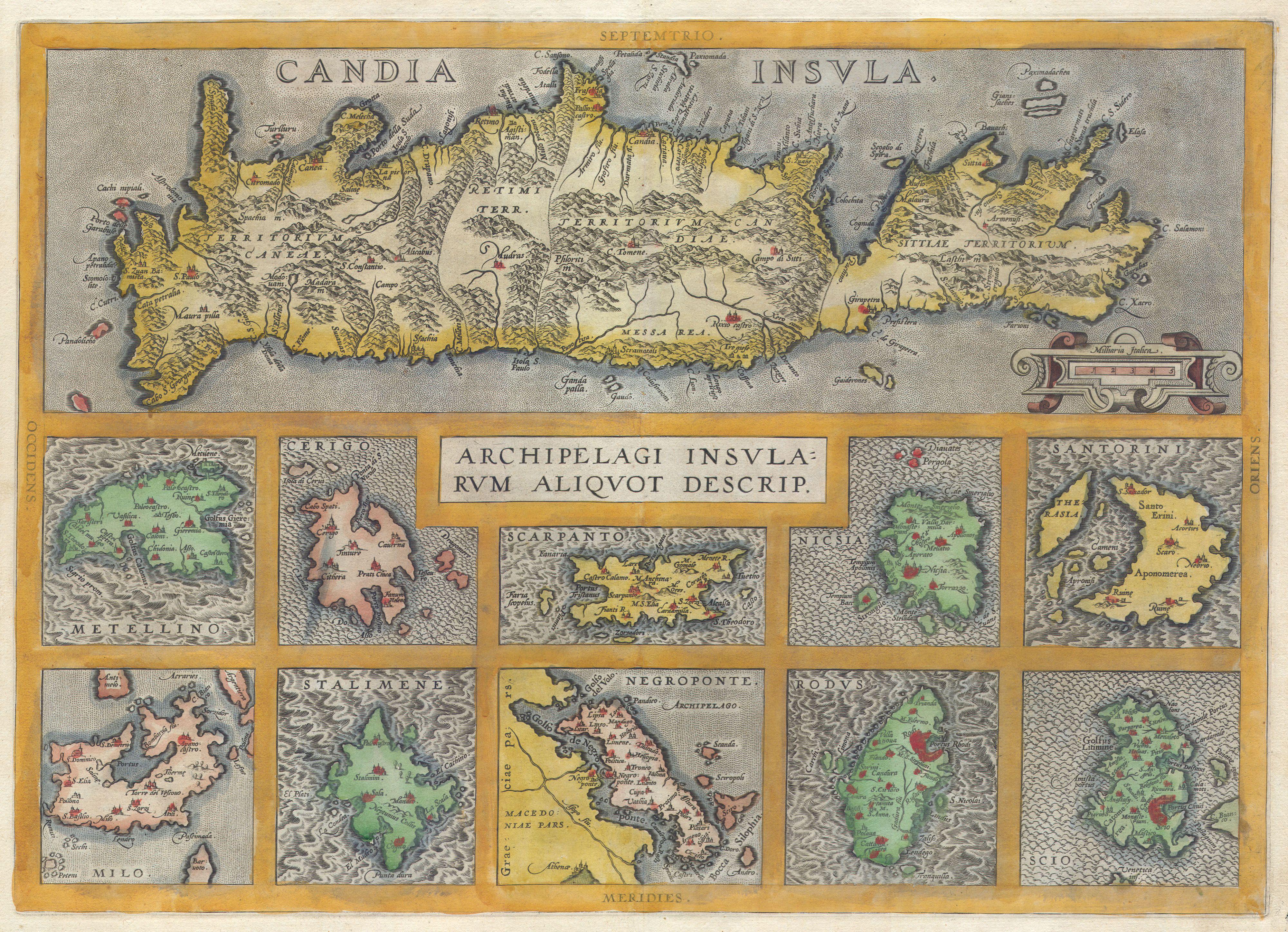
English: A rare and beautiful 1584 Abraham Ortelius map of Crete and ten other Greek islands: Metellino (Mitiline, Lesbos), Cerigo, Scarpanto (Karpathos), Nicsia (Naxos), Santorini, Milo, Stalimene (Limnos), Negroponte (Euboea), Rodus (Rhodes, home of the Colossus of Rhodes), and Scio (Chios). Beautiful, rich, hand color. |
|||||||||||||||||||||||
| Datum | 1584 | |||||||||||||||||||||||
| Afmetingen | hoogte: 14,5 in (36,8 cm); breedte: 20 in (50,8 cm) | |||||||||||||||||||||||
| Inventarisnummer |
Geographicus link: CandiaInsula-ortelius-1584 |
|||||||||||||||||||||||
| Bron/fotograaf |
|
|||||||||||||||||||||||
| Toestemming (Hergebruik van dit bestand) |
|
|||||||||||||||||||||||
| Andere versies | ||||||||||||||||||||||||

_and_10_Greek_Islands_-_Geographicus_-_CandiaInsula-ortelius-1584.jpg)
_and_10_Greek_Islands_-_Geographicus_-_CandiaInsula-ortelius-1584_(cropped).jpg)
Bestandsgeschiedenis
Klik op een datum/tijd om het bestand te zien zoals het destijds was.
| Datum/tijd | Miniatuur | Afmetingen | Gebruiker | Opmerking | |
|---|---|---|---|---|---|
| huidige versie | 24 mrt 2011 10:46 | | 4.000 × 2.895 (2,94 MB) | BotMultichillT | {{subst:User:Multichill/Geographicus |link=http://www.geographicus.com/P/AntiqueMap/CandiaInsula-ortelius-1584 |product_name=1584 Ortelius Map of Crete (Candia) and 10 Greek Islands |map_title=Candia Insula - Archipelagi Insularum Aliquot Descrip. |descri |
Bestandsgebruik
Dit bestand wordt op de volgende pagina gebruikt:
Globaal bestandsgebruik
De volgende andere wiki's gebruiken dit bestand:
- Gebruikt op en.wikipedia.org
- Gebruikt op fr.wikipedia.org
_and_10_Greek_Islands_-_Geographicus_-_CandiaInsula-ortelius-1584.jpg)