
Bestand:2010 Pacific hurricane season summary map.png

Grootte van deze voorvertoning: 800 × 494 pixels. Andere resoluties: 320 × 198 pixels | 640 × 396 pixels | 1.024 × 633 pixels | 1.280 × 791 pixels | 2.560 × 1.582 pixels | 4.000 × 2.472 pixels.
Oorspronkelijk bestand (4.000 × 2.472 pixels, bestandsgrootte: 5,05 MB, MIME-type: image/png)
| Dit is een bestand van Wikimedia Commons. Onderstaande beschrijving komt van de beschrijving van het bestand daar. |
| Beschrijving |
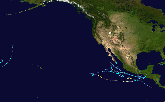
English: This map shows the tracks of all tropical cyclones in the 2010 Pacific hurricane season. The points show the location of each storm at 6-hour intervals. The colour represents the storm's maximum sustained wind speeds as classified in the Saffir-Simpson Hurricane Scale (see below), and the shape of the data points represent the type of the storm.
Tropical depression (≤38 mph, ≤62 km/h)
Tropical storm (39–73 mph, 63–118 km/h)
Category 1 (74–95 mph, 119–153 km/h)
Category 2 (96–110 mph, 154–177 km/h)
Category 3 (111–129 mph, 178–208 km/h)
Category 4 (130–156 mph, 209–251 km/h)
Category 5 (≥157 mph, ≥252 km/h)
Unknown
Storm type |
| Bron | Created using Wikipedia:WikiProject Tropical cyclones/Tracks. The background image is from NASA [1]. The tracking data is from the National Hurricane Center and the Central Pacific Hurricane Center's Northeast and North Central Pacific hurricane database |
| Auteur | Cyclonebiskit |

|
Dit bestand kan geactualiseerd worden om nieuwe informatie te weerspiegelen. Indien je een specifieke versie van het bestand wil gebruiken zonder dat er nieuwe updates plaatsvinden, dien je die betrokken versie te uploaden als een afzonderlijk bestand. |
| Dit werk vrijgegeven in het publieke domein door de auteur, Cyclonebiskit. Dit is wereldwijd van toepassing. In sommige landen is dit wettelijk niet mogelijk; in die gevallen geldt: Cyclonebiskit staat iedereen toe dit werk voor eender welk doel te gebruiken, zonder enige voorwaarden, tenzij zulke voorwaarden door de wet worden voorgeschreven. |
Bestandsgeschiedenis
Klik op een datum/tijd om het bestand te zien zoals het destijds was.
| Datum/tijd | Miniatuur | Afmetingen | Gebruiker | Opmerking | |
|---|---|---|---|---|---|
| huidige versie | 7 jun 2020 01:13 | | 4.000 × 2.472 (5,05 MB) | Supportstorm | Slight correction |
| 13 jan 2016 00:10 |  | 4.000 × 2.472 (6,08 MB) | Cyclonebiskit | Standardize size/dimensions | |
| 22 jun 2015 08:41 |  | 3.000 × 1.854 (2,47 MB) | Cyclonebiskit | adjust point size, higher quality | |
| 27 jun 2011 14:00 |  | 3.000 × 1.854 (1,96 MB) | Cyclonebiskit | final HURDAT update | |
| 23 nov 2010 23:29 |  | 3.000 × 1.904 (2,14 MB) | Cyclonebiskit | updated; 11E and Hermine kept separate | |
| 22 nov 2010 04:47 |  | 3.000 × 2.340 (3,91 MB) | Syntheticalconnections | show extratropical track points | |
| 22 nov 2010 04:44 |  | 3.000 × 2.360 (3,85 MB) | Syntheticalconnections | up the res | |
| 22 nov 2010 04:41 |  | 1.024 × 806 (761 kB) | Syntheticalconnections | update without crude tracks (Georgette TCR) | |
| 21 nov 2010 20:18 |  | 3.000 × 2.480 (3,98 MB) | Cyclonebiskit | full track of 11E/Hermine to avoid confusion | |
| 21 nov 2010 20:16 |  | 3.000 × 1.898 (2,13 MB) | Cyclonebiskit | long overdue update |
Bestandsgebruik
Dit bestand wordt op de volgende pagina gebruikt:
Globaal bestandsgebruik
De volgende andere wiki's gebruiken dit bestand:
- Gebruikt op de.wikipedia.org
- Gebruikt op en.wikipedia.org
- List of Pacific hurricanes
- 2010 Pacific hurricane season
- Tropical Storm Agatha
- Template:2010 Pacific hurricane season buttons
- Timeline of the 2010 Pacific hurricane season
- Hurricane Celia (2010)
- Hurricane Frank (2010)
- Tropical Storm Hermine (2010)
- User:Yellow Evan/Hurricane Darby
- Tropical Storm Georgette (2010)
- Gebruikt op es.wikipedia.org
- Gebruikt op ko.wikipedia.org
- Gebruikt op pt.wikipedia.org
- Gebruikt op simple.wikipedia.org
- Gebruikt op www.wikidata.org
- Gebruikt op zh.wikipedia.org