
Bestand:Administrative map of Romania, 1952-1956.png

Grootte van deze voorvertoning: 800 × 572 pixels. Andere resoluties: 320 × 229 pixels | 640 × 458 pixels | 1.024 × 732 pixels | 1.400 × 1.001 pixels.
Oorspronkelijk bestand (1.400 × 1.001 pixels, bestandsgrootte: 338 kB, MIME-type: image/png)
| Dit is een bestand van Wikimedia Commons. Onderstaande beschrijving komt van de beschrijving van het bestand daar. |
| Beschrijving |
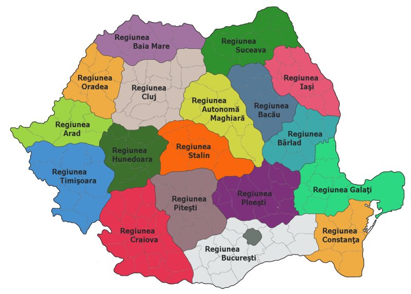
Administrative map of Romania, 1952-1956
|
| Bron |
De oorspronkelijke beschrijving van deze afbeelding stond hier. Alle volgende gebruikersnamen verwijzen naar ro.wikipedia. |
| Auteur | ro:user:Radufan |
| Dit werk vrijgegeven in het publieke domein door de auteur, Radufan. Dit is wereldwijd van toepassing. In sommige landen is dit wettelijk niet mogelijk; in die gevallen geldt: |
Oorspronkelijk uploadlogboek
De oorspronkelijke beschrijving van deze afbeelding stond hier. Alle volgende gebruikersnamen verwijzen naar ro.wikipedia.
| Upload date | User | Bytes | Dimensions | Comment |
|---|---|---|---|---|
| 2006-10-02 00:26:09 | Radufan | 346530 | 1400×1001 | Impartirea Administrativ-teritoriala a Romaniei la 1953 |
Bestandsgeschiedenis
Klik op een datum/tijd om het bestand te zien zoals het destijds was.
| Datum/tijd | Miniatuur | Afmetingen | Gebruiker | Opmerking | |
|---|---|---|---|---|---|
| huidige versie | 6 feb 2010 14:29 | | 1.400 × 1.001 (338 kB) | Alex:D | {{Information |Description=Administrative map of Romania, 1952-1956 *Bucharest had a special status of "town subordinated to the Republic" *Each region bears the name of the capital city, except: **Autonomous Hungarian Region — Târgu Mureş **Hunedoara |
Bestandsgebruik
Dit bestand wordt op de volgende pagina gebruikt:
Globaal bestandsgebruik
De volgende andere wiki's gebruiken dit bestand:
- Gebruikt op da.wikipedia.org
- Gebruikt op en.wikipedia.org
- Gebruikt op es.wikipedia.org
- Gebruikt op fr.wikipedia.org
- Gebruikt op hu.wikipedia.org
- Gebruikt op it.wikipedia.org
- Gebruikt op ro.wikipedia.org
- Județul Teleorman
- Regiunea Autonomă Maghiară
- Utilizator:Radufan
- Regiunea Timișoara
- Republica Populară Română
- Format:RegiuniRPR
- Regiunea Arad
- Regiunea Cluj
- Regiunea Stalin
- Regiunea Hunedoara
- Organizarea teritorială a Republicii Populare Române
- Regiunea Craiova
- Regiunea Ploiești
- Regiunea Pitești
- Regiunea Oradea
- Regiunea Baia Mare
- Regiunea București
- Regiunea Constanța
- Regiunea Galați
- Regiunea Bacău
- Regiunea Iași
- Regiunea Suceava
- Regiunea Bihor
- Regiunea Bârlad
- Diviziunile administrative istorice ale României
- Gebruikt op ru.wikipedia.org