
Bestand:CarthageMap.png
Geen hogere resolutie beschikbaar.
CarthageMap.png (770 × 447 pixels, bestandsgrootte: 106 kB, MIME-type: image/png)
| Dit is een bestand van Wikimedia Commons. Onderstaande beschrijving komt van de beschrijving van het bestand daar. |
Beschrijving
| Beschrijving |
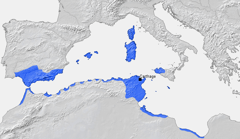
Location of Carthage and Carthaginian sphere of influence prior to the First Punic War (264 BC) Source: Self-made, based on Putzger Atlas und Chronik zur Weltgeschichte, Berlin, 2002 Template: [1] Author: BishkekRocks |
||
| Datum | 18 maart 2006 (originele uploaddatum) | ||
| Bron | Geen machineleesbare bron opgegeven. Eigen werk aangenomen (gebaseerd op auteursrechtclaims). | ||
| Auteur | Geen machineleesbare auteur aanwezig. Op basis van auteursrechtclaims wordt auteur BishkekRocks aangenomen. | ||
| Andere versies |
|

Licentie
| Ik, de auteursrechthebbende van dit werk, geef dit werk vrij in het publieke domein. Dit is wereldwijd van toepassing. In sommige landen is dit wettelijk niet mogelijk; in die gevallen geldt: Ik sta iedereen toe dit werk voor eender welk doel te gebruiken, zonder enige voorwaarden, tenzij zulke voorwaarden door de wet worden voorgeschreven. |
Bestandsgeschiedenis
Klik op een datum/tijd om het bestand te zien zoals het destijds was.
| Datum/tijd | Miniatuur | Afmetingen | Gebruiker | Opmerking | |
|---|---|---|---|---|---|
| huidige versie | 6 apr 2023 21:50 | | 770 × 447 (106 kB) | Titanjs | Reverted to version as of 15:31, 18 March 2006 (UTC) |
| 23 mrt 2016 16:16 |  | 770 × 447 (288 kB) | Michczu | drobna poprawka | |
| 19 sep 2014 18:52 |  | 770 × 447 (128 kB) | Daygum | True areas occupied by chartaginians | |
| 18 mrt 2006 17:31 |  | 770 × 447 (106 kB) | BishkekRocks | Location of Carthage and Carthaginian influence sphere before the First Punic War (264 BC) Source: Self-made, based on Putzger Atlas und Chronik zur Weltgeschichte, Berlin, 2002 Template: [http://www.demis.nl/wms/mapclip.htm] Author: ~~~ [[Category:Ca |
Bestandsgebruik
Dit bestand wordt op de volgende pagina gebruikt:
Globaal bestandsgebruik
De volgende andere wiki's gebruiken dit bestand:
- Gebruikt op ar.wikipedia.org
- Gebruikt op ast.wikipedia.org
- Gebruikt op azb.wikipedia.org
- Gebruikt op az.wikipedia.org
- Gebruikt op ba.wikipedia.org
- Gebruikt op be-tarask.wikipedia.org
- Gebruikt op bg.wikipedia.org
- Gebruikt op bm.wikipedia.org
- Gebruikt op br.wikipedia.org
- Gebruikt op bs.wikipedia.org
- Gebruikt op ca.wikipedia.org
- Gebruikt op cdo.wikipedia.org
- Gebruikt op cs.wikipedia.org
- Gebruikt op de.wikipedia.org
- Gebruikt op el.wikipedia.org
- Gebruikt op en.wikipedia.org
- Gebruikt op eo.wikipedia.org
- Gebruikt op es.wikipedia.org
Globaal gebruik van dit bestand bekijken.