
Bestand:Eskişehir districts.png

Grootte van deze voorvertoning: 738 × 600 pixels. Andere resoluties: 295 × 240 pixels | 591 × 480 pixels | 950 × 772 pixels.
Oorspronkelijk bestand (950 × 772 pixels, bestandsgrootte: 44 kB, MIME-type: image/png)
| Dit is een bestand van Wikimedia Commons. Onderstaande beschrijving komt van de beschrijving van het bestand daar. |
Beschrijving
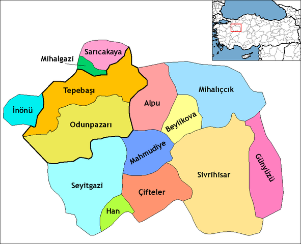
| Beschrijving | Map of the districts of Eskişehir province in Turkey. Created by Rarelibra 19:54, 1 December 2006 (UTC) for public domain use, using MapInfo Professional v8.5 and various mapping resources. Edited by One Homo Sapiens Corrected text where İ,Ş,ı,ğ,or ş occurs in name. Source: [statoids-com]. Increased font size and enhanced color differences among adjacent districts. |
| Datum | 10 april 2007 (originele uploaddatum) |
| Bron | Geen machineleesbare bron opgegeven. Eigen werk aangenomen (gebaseerd op auteursrechtclaims). |
| Auteur | Geen machineleesbare auteur aanwezig. Op basis van auteursrechtclaims wordt auteur Denizz~commonswiki aangenomen. |
Licentie
| Ik, de auteursrechthebbende van dit werk, geef dit werk vrij in het publieke domein. Dit is wereldwijd van toepassing. In sommige landen is dit wettelijk niet mogelijk; in die gevallen geldt: Ik sta iedereen toe dit werk voor eender welk doel te gebruiken, zonder enige voorwaarden, tenzij zulke voorwaarden door de wet worden voorgeschreven. |
derivative works
Afgeleide werken van dit bestand:
Bestandsgeschiedenis
Klik op een datum/tijd om het bestand te zien zoals het destijds was.
| Datum/tijd | Miniatuur | Afmetingen | Gebruiker | Opmerking | |
|---|---|---|---|---|---|
| huidige versie | 19 dec 2013 22:44 | | 950 × 772 (44 kB) | Chumwa | marked the central districts |
| 16 dec 2013 00:02 |  | 950 × 772 (41 kB) | Chumwa | Eskişehir district was splitted in Tepebaşı and Odunpazarı district in 2009 | |
| 29 dec 2008 00:22 |  | 1.056 × 816 (37 kB) | One Homo Sapiens | Corrected text where İ,Ş,ı,ğ,or ş occurs in name. Source: [statoids-com]. Increased font size and enhanced color differences among adjacent districts. | |
| 10 apr 2007 02:45 |  | 1.056 × 816 (31 kB) | Denizz~commonswiki | == Summary == Map of the districts of Eskişehir province in Turkey. Created by Rarelibra 19:54, 1 December 2006 (UTC) for public domain use, using MapInfo Professional v8.5 and various mapping resources. == Licensing == {{PD-self}} <!- |
Bestandsgebruik
Dit bestand wordt op de volgende 14 pagina's gebruikt:
Globaal bestandsgebruik
De volgende andere wiki's gebruiken dit bestand:
- Gebruikt op ar.wikipedia.org
- Gebruikt op ast.wikipedia.org
- Gebruikt op azb.wikipedia.org
- Gebruikt op az.wikipedia.org
- Gebruikt op ba.wikipedia.org
- Gebruikt op ca.wikipedia.org
- Gebruikt op cs.wikipedia.org
- Gebruikt op de.wikipedia.org
- Gebruikt op diq.wikipedia.org
- Gebruikt op en.wikipedia.org
- Gebruikt op en.wiktionary.org
- Gebruikt op eo.wikipedia.org
Globaal gebruik van dit bestand bekijken.