
Bestand:Gonâve microplate.png

Grootte van deze voorvertoning: 800 × 506 pixels. Andere resoluties: 320 × 202 pixels | 640 × 405 pixels | 1.024 × 647 pixels | 1.280 × 809 pixels | 2.115 × 1.337 pixels.
Oorspronkelijk bestand (2.115 × 1.337 pixels, bestandsgrootte: 1,3 MB, MIME-type: image/png)
| Dit is een bestand van Wikimedia Commons. Onderstaande beschrijving komt van de beschrijving van het bestand daar. |
| Beschrijving |
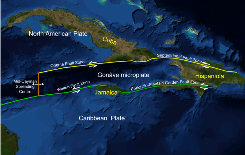
English: Screen shot from Nasa WorldWind software of NW Caribbean area |
| Datum | (UTC) |
| Bron | |
| Auteur |
|
| Dit is een geretoucheerde foto, wat betekent dat de originele versie digitaal aangepast is. Aanpassingen: Added plate boundaries and main faults, island names and plate names. Het origineel kan hier bekeken worden: NWCaribbean satellite.png. Aanpassingen gedaan door Mikenorton.
|
| Deze afbeelding bevindt zich in het publiek domein omdat het een screenshot is van NASA’s software World Wind die gebruik maakt van een publiek domein-laag, zoals Blue Marble, MODIS, Landsat, SRTM, USGS of GLOBE.
|
 |
Oorspronkelijk uploadlogboek
This image is a derivative work of the following images:
- File:NWCaribbean_satellite.png licensed with PD-WorldWind
- 2010-02-07T16:43:33Z Mikenorton 2111x1337 (1221182 Bytes) {{Information |Description={{en|1=Screen shot from Nasa WorldWind software of NW Caribbean area}} |Source=NASA WorldWind |Author=Mikenorton |Date=2010-02-07 |Permission={{PD-WorldWind}} |other_versions= }} [[Category:Satelli
Uploaded with derivativeFX
Bestandsgeschiedenis
Klik op een datum/tijd om het bestand te zien zoals het destijds was.
| Datum/tijd | Miniatuur | Afmetingen | Gebruiker | Opmerking | |
|---|---|---|---|---|---|
| huidige versie | 7 feb 2010 18:50 | | 2.115 × 1.337 (1,3 MB) | Mikenorton | {{Information |Description={{en|1=Screen shot from Nasa WorldWind software of NW Caribbean area}} |Source=*File:NWCaribbean_satellite.png |Date=2010-02-07 16:49 (UTC) |Author=*File:NWCaribbean_satellite.png: Mikenorton *derivative work: ~~~ |P |
Bestandsgebruik
Dit bestand wordt op de volgende 2 pagina's gebruikt:
Globaal bestandsgebruik
De volgende andere wiki's gebruiken dit bestand:
- Gebruikt op bn.wikipedia.org
- Gebruikt op ca.wikipedia.org
- Gebruikt op cs.wikipedia.org
- Gebruikt op de.wikipedia.org
- Gebruikt op en.wikipedia.org
- Cayman Trough
- 1946 Dominican Republic earthquake
- 1692 Jamaica earthquake
- Enriquillo–Plantain Garden fault zone
- Septentrional-Oriente fault zone
- 2010 Haiti earthquake
- List of earthquakes in Cuba
- Talk:2010 Haiti earthquake/Archive 2
- Gonâve Microplate
- Geology of Jamaica
- Walton fault zone
- Mid-Cayman Rise
- Gebruikt op eo.wikipedia.org
- Gebruikt op es.wikipedia.org
- Gebruikt op fa.wikipedia.org
- Gebruikt op fi.wikipedia.org
- Gebruikt op fr.wikipedia.org
- Gebruikt op he.wikipedia.org
- Gebruikt op ht.wikipedia.org
- Gebruikt op id.wikipedia.org
- Gebruikt op it.wikipedia.org
- Gebruikt op ja.wikipedia.org
- Gebruikt op ko.wikipedia.org
- Gebruikt op no.wikipedia.org
- Gebruikt op pl.wikipedia.org
- Gebruikt op ru.wikipedia.org
- Gebruikt op th.wikipedia.org
- Gebruikt op uk.wikipedia.org
Globaal gebruik van dit bestand bekijken.