
Bestand:Kenya topographic map-fr.svg

Afmetingen van deze voorvertoning van het type PNG van dit SVG-bestand: 575 × 599 pixels Andere resoluties: 230 × 240 pixels | 460 × 480 pixels | 737 × 768 pixels | 982 × 1.024 pixels | 1.965 × 2.048 pixels | 1.181 × 1.231 pixels.
Oorspronkelijk bestand (SVG-bestand, nominaal 1.181 × 1.231 pixels, bestandsgrootte: 3,26 MB)
| Dit is een bestand van Wikimedia Commons. Onderstaande beschrijving komt van de beschrijving van het bestand daar. |
Beschrijving
| Beschrijving |
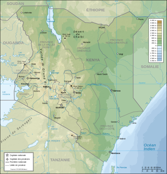
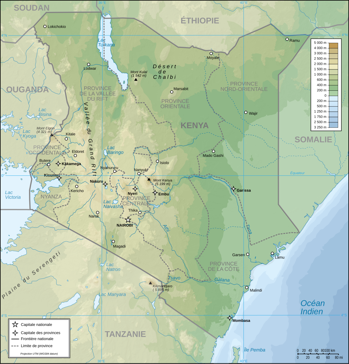
Français : Carte topographique du Kenya. Version française
English: Topographic map in French of Kenya |
| Datum | |
| Bron |
Eigen werk (Originele tekst: Own Work made with Inkscape From Topographic map : NASA Shuttle Radar Topography Mission (SRTM3 v.2) (public domain) edited with Global Mapper 9 from Visualization Software LLC and vectorized with Inkscape ; UTM projection ; WGS84 datum ; shaded relief (composite image of N-W, W and N lightning positions) ; Rivers, borders, cities : Demis add-on for World Wind ; Other references used : * NASA World Wind ; * File:Kenya-relief-map-towns.jpg ; Notes : The shaded relief is a raster image embedded in the SVG file which increases its size. If you want a lighter map for other purposes, delete the shaded relief image in your file.) |
| Auteur | Pinpin |
| Andere versies |
Afgeleide werken van dit bestand: |
| SVG ontwikkeling | De broncode van dit SVG-bestand is deugdelijk. |

| Cameralocatie | | Deze en andere afbeeldingen in: OpenStreetMap |
|---|
Licentie
Ik, de auteursrechthebbende van dit werk, maak het hierbij onder de volgende licenties beschikbaar:
| Copyleft: dit kunstwerk is vrij; u mag het heruitgeven en/of wijzigen in overeenkomst met de voorwaarden van de Free Art-licentie.
U kunt een voorbeeld van de licentie vinden op de website van Copyleft Attitude als ook op andere websites. |
This file is licensed under the Creative Commons Attribution-Share Alike Attribution-Share Alike 4.0 International, 3.0 Unported, 2.5 Generic, 2.0 Generic and 1.0 Generic license.
- De gebruiker mag:
- Delen – het werk kopiëren, verspreiden en doorgeven
- Remixen – afgeleide werken maken
- Onder de volgende voorwaarden:
- naamsvermelding – U moet op een gepaste manier aan naamsvermelding doen, een link naar de licentie geven, en aangeven of er wijzigingen in het werk zijn aangebracht. U mag dit op elke redelijke manier doen, maar niet zodanig dat de indruk wordt gewekt dat de licentiegever instemt met uw werk of uw gebruik van zijn werk.
- Gelijk delen – Als u het werk heeft geremixt, veranderd, of erop heeft voortgebouwd, moet u het gewijzigde materiaal verspreiden onder dezelfde licentie als het oorspronkelijke werk, of een daarmee compatibele licentie.
U mag zelf één van de licenties kiezen.
| Aantekeningen | Deze afbeelding is aangetekend: Bekijk de aantekeningen op Commons |
Bestandsgeschiedenis
Klik op een datum/tijd om het bestand te zien zoals het destijds was.
| Datum/tijd | Miniatuur | Afmetingen | Gebruiker | Opmerking | |
|---|---|---|---|---|---|
| huidige versie | 14 aug 2023 21:48 | | 1.181 × 1.231 (3,26 MB) | Sémhur | Correction des latitudes et longitudes |
| 30 apr 2008 12:00 |  | 1.181 × 1.231 (3,28 MB) | Sémhur | Orthograph : provence => province | |
| 7 apr 2008 21:48 |  | 1.181 × 1.231 (3,28 MB) | Pinpin | == Description == {{Information |Description={{fr|Carte topographique du Kenya. Version française}} {{en|Topographic map in French of Kenya}} |Source=Own Work made with Inkscape From <br/>Topographic map : [http://www2.jpl.nasa.gov/srtm NASA Shuttle Rada |
Bestandsgebruik
Dit bestand wordt op de volgende pagina gebruikt:
Globaal bestandsgebruik
De volgende andere wiki's gebruiken dit bestand:
- Gebruikt op avk.wikipedia.org
- Gebruikt op ca.wikipedia.org
- Gebruikt op de.wikipedia.org
- Gebruikt op en.wikipedia.org
- Gebruikt op es.wikipedia.org
- Gebruikt op fr.wikipedia.org
- Gebruikt op ps.wikipedia.org
- Gebruikt op ru.wikipedia.org
- Gebruikt op uk.wikipedia.org