
Bestand:Locator Electoral Palatinate within the Holy Roman Empire (1618).svg

Afmetingen van deze voorvertoning van het type PNG van dit SVG-bestand: 658 × 600 pixels Andere resoluties: 263 × 240 pixels | 527 × 480 pixels | 843 × 768 pixels | 1.123 × 1.024 pixels | 2.247 × 2.048 pixels | 2.769 × 2.524 pixels.
Oorspronkelijk bestand (SVG-bestand, nominaal 2.769 × 2.524 pixels, bestandsgrootte: 1 MB)
| Dit is een bestand van Wikimedia Commons. Onderstaande beschrijving komt van de beschrijving van het bestand daar. |
.svg)
Beschrijving
| Beschrijving |
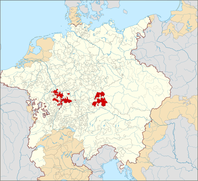
English: Locator Map of the Electoral Palatinate within the Holy Roman Empire (1618)
The Electoral Palatinate in 1618.
Territories of the Holy Roman Empire.
Territories connected with the Holy Roman Empire, including the Imperial Italy, the Swiss Confederacy, Barrois mouvant, Sedan, Lauenburg and Bütow, Ducal Prussia, the Duchy of Schleswig and the Dutch Republic.
Territories outside the Holy Roman Empire.
Nederlands: Locatiekaart van de Keur-Palts binnen het Heilige Roomse Rijk (1618) |
| Datum | |
| Bron |
|
| Auteur |
Deze niet W3C-verklaarde vectorafbeelding is gemaakt met Inkscape . |
Licentie
Ik, de auteursrechthebbende van dit werk, maak het hierbij onder de volgende licentie beschikbaar:
Dit bestand is gelicenseerd onder de Creative Commons Naamsvermelding-GelijkDelen 4.0 Internationaal licentie.
- De gebruiker mag:
- Delen – het werk kopiëren, verspreiden en doorgeven
- Remixen – afgeleide werken maken
- Onder de volgende voorwaarden:
- naamsvermelding – U moet op een gepaste manier aan naamsvermelding doen, een link naar de licentie geven, en aangeven of er wijzigingen in het werk zijn aangebracht. U mag dit op elke redelijke manier doen, maar niet zodanig dat de indruk wordt gewekt dat de licentiegever instemt met uw werk of uw gebruik van zijn werk.
- Gelijk delen – Als u het werk heeft geremixt, veranderd, of erop heeft voortgebouwd, moet u het gewijzigde materiaal verspreiden onder dezelfde licentie als het oorspronkelijke werk, of een daarmee compatibele licentie.
Bestandsgeschiedenis
Klik op een datum/tijd om het bestand te zien zoals het destijds was.
| Datum/tijd | Miniatuur | Afmetingen | Gebruiker | Opmerking | |
|---|---|---|---|---|---|
| huidige versie | 28 jan 2015 02:55 | | 2.769 × 2.524 (1 MB) | Sir Iain | Corrected Bohemian border |
| 27 jan 2015 16:24 |  | 2.769 × 2.524 (1.018 kB) | Sir Iain | Corrected mistake in Bohemia | |
| 22 jan 2015 16:19 |  | 2.769 × 2.524 (1.022 kB) | Sir Iain | Redone Schleswig-Holstein | |
| 5 jan 2015 02:53 |  | 2.769 × 2.524 (998 kB) | Sir Iain | Savoy shown as core territory of the HRR | |
| 23 dec 2014 22:27 |  | 2.769 × 2.524 (998 kB) | Sir Iain | Removed the Imperial border between Germany and the Netherlands | |
| 23 dec 2014 03:18 |  | 2.769 × 2.524 (1.002 kB) | Sir Iain | User created page with UploadWizard |
Bestandsgebruik
Dit bestand wordt op de volgende pagina gebruikt:
Globaal bestandsgebruik
De volgende andere wiki's gebruiken dit bestand:
- Gebruikt op af.wikipedia.org
- Gebruikt op ar.wikipedia.org
- Gebruikt op ast.wikipedia.org
- Gebruikt op az.wikipedia.org
- Gebruikt op bg.wikipedia.org
- Gebruikt op cs.wikipedia.org
- Gebruikt op en.wikipedia.org
- Gebruikt op fa.wikipedia.org
- Gebruikt op fr.wikipedia.org
- Gebruikt op fy.wikipedia.org
- Gebruikt op it.wikipedia.org
- Gebruikt op ko.wikipedia.org
- Gebruikt op ru.wikipedia.org
- Gebruikt op simple.wikipedia.org
- Gebruikt op sr.wikipedia.org
- Gebruikt op uk.wikipedia.org
- Gebruikt op www.wikidata.org
.svg)