
Bestand:Pinus lambertiana USGS range map 2.png

Grootte van deze voorvertoning: 342 × 600 pixels. Andere resoluties: 137 × 240 pixels | 273 × 480 pixels | 924 × 1.621 pixels.
Oorspronkelijk bestand (924 × 1.621 pixels, bestandsgrootte: 89 kB, MIME-type: image/png)
| Dit is een bestand van Wikimedia Commons. Onderstaande beschrijving komt van de beschrijving van het bestand daar. |
Beschrijving
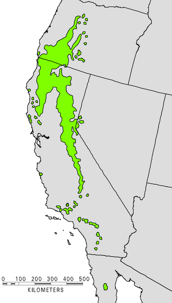
- U.S. Forestry distribution map showing the native range of the Sugar Pine (Pinus lambertiana).
- Source
[1] (pdf file)
Licentie
Deze afbeelding bevindt zich in het publiek domein omdat het materiaal bevat dat oorspronkelijk afkomstig is van de United States Geological Survey, een agentschap van de United States Department of the Interior. Voor meer informatie, zie het officiële USGS-auteursrechtenbeleid
|
Bestandsgeschiedenis
Klik op een datum/tijd om het bestand te zien zoals het destijds was.
| Datum/tijd | Miniatuur | Afmetingen | Gebruiker | Opmerking | |
|---|---|---|---|---|---|
| huidige versie | 7 jan 2008 15:35 | | 924 × 1.621 (89 kB) | MPF | Clearer version from USGS |
| 21 okt 2006 19:44 | 374 × 1.004 (77 kB) | Wsiegmund | Re-edited image colors for clarity | ||
| 21 okt 2006 04:57 | 374 × 1.004 (246 kB) | Wsiegmund | == Summary == US Forestry map showing the native range of the Sugar Pine: http://www.na.fs.fed.us/Spfo/pubs/silvics_manual/Volume_1/pinus/lambertiana.htm == Licensing == {{PD-USGov}} |
Bestandsgebruik
Dit bestand wordt op de volgende pagina gebruikt:
Globaal bestandsgebruik
De volgende andere wiki's gebruiken dit bestand:
- Gebruikt op arz.wikipedia.org
- Gebruikt op ast.wikipedia.org
- Gebruikt op cs.wikipedia.org
- Gebruikt op el.wikipedia.org
- Gebruikt op es.wikipedia.org
- Gebruikt op et.wikipedia.org
- Gebruikt op fa.wikipedia.org
- Gebruikt op fr.wikipedia.org
- Gebruikt op it.wikipedia.org
- Gebruikt op pl.wikipedia.org
- Gebruikt op pt.wikipedia.org
- Gebruikt op ru.wikipedia.org
- Gebruikt op vi.wikipedia.org
- Gebruikt op www.wikidata.org