
Bestand:Pyrenees topo map-blank.jpg

Grootte van deze voorvertoning: 800 × 475 pixels. Andere resoluties: 320 × 190 pixels | 640 × 380 pixels | 1.024 × 608 pixels | 1.280 × 760 pixels | 2.560 × 1.520 pixels | 4.787 × 2.842 pixels.
Oorspronkelijk bestand (4.787 × 2.842 pixels, bestandsgrootte: 4,82 MB, MIME-type: image/jpeg)
| Dit is een bestand van Wikimedia Commons. Onderstaande beschrijving komt van de beschrijving van het bestand daar. |
Beschrijving
| Beschrijving |
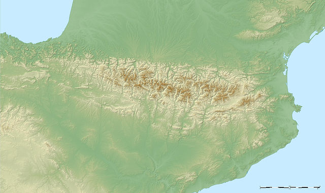
English: Large blank map showing the relief of the Pyrenees mountains.
Français : Carte vierge montrant le relief des Pyrénées.
UTM projection ; WGS84 geoid ; shaded relief (composite image of N-W, W and N lightning positions) |
||
| Datum | May 2007 (modified September 2008) | ||
| Bron |
Own work ;
|
||
| Auteur | Eric Gaba (Sting - fr:Sting) | ||
| Toestemming (Hergebruik van dit bestand) |
|
||
| Andere versies |
[]
|


Licentie
Ik, de auteursrechthebbende van dit werk, maak het hierbij onder de volgende licenties beschikbaar:

|
Toestemming wordt verleend voor het kopiëren, verspreiden en/of wijzigen van dit document onder de voorwaarden van de GNU-licentie voor vrije documentatie, versie 1.2 of enige latere versie als gepubliceerd door de Free Software Foundation; zonder Invariant Sections, zonder Front-Cover Texts, en zonder Back-Cover Texts. Een kopie van de licentie is opgenomen in de sectie GNU-licentie voor vrije documentatie. |
| Dit bestand is gelicenseerd onder de Creative Commons-licentie Naamsvermelding-Gelijk delen 3.0 Unported | ||
| ||
| Deze licentietag is toegevoegd aan dit bestand in verband met de GFDL licentie-update. |
Dit bestand is gelicenseerd onder de Creative Commons-licenties Naamsvermelding-Gelijk delen 2.5 Algemeen, 2.0 Algemeen en 1.0 Algemeen.
- De gebruiker mag:
- Delen – het werk kopiëren, verspreiden en doorgeven
- Remixen – afgeleide werken maken
- Onder de volgende voorwaarden:
- naamsvermelding – U moet op een gepaste manier aan naamsvermelding doen, een link naar de licentie geven, en aangeven of er wijzigingen in het werk zijn aangebracht. U mag dit op elke redelijke manier doen, maar niet zodanig dat de indruk wordt gewekt dat de licentiegever instemt met uw werk of uw gebruik van zijn werk.
- Gelijk delen – Als u het werk heeft geremixt, veranderd, of erop heeft voortgebouwd, moet u het gewijzigde materiaal verspreiden onder dezelfde licentie als het oorspronkelijke werk, of een daarmee compatibele licentie.
U mag zelf één van de licenties kiezen.
Bestandsgeschiedenis
Klik op een datum/tijd om het bestand te zien zoals het destijds was.
| Datum/tijd | Miniatuur | Afmetingen | Gebruiker | Opmerking | |
|---|---|---|---|---|---|
| huidige versie | 23 sep 2008 06:50 | | 4.787 × 2.842 (4,82 MB) | Sting | New standard colors |
| 31 mei 2007 04:38 |  | 4.787 × 2.842 (4,84 MB) | Sting | Other type of compression | |
| 31 mei 2007 04:30 |  | 4.787 × 2.842 (4,82 MB) | Sting | {{Information |Description=Blank map showing the relief of the Pyrenees mountains |Source=Own work ;<br/>Topographic data : [http://www2.jpl.nasa.gov/srtm NASA Shuttle Radar Topography Mission] (SRTM3 v.2) (public domain) edited with [htt |
Bestandsgebruik
Dit bestand wordt op de volgende 83 pagina's gebruikt:
- Alberamassief
- Aneto
- Arainburu
- Ax-3 Domaines
- Balaïtous
- Bastiments
- Besiberri
- Brèche de Roland
- Casque du Marboré
- Cilindro de Marboré
- Cirque de Gavarnie
- Col d'Agnes
- Col d'Aspin
- Col d'Aubisque
- Col de Latrape
- Col de Marie-Blanque
- Col de Menté
- Col de Portet
- Col de Portet-d'Aspet
- Col de Puymorens
- Col de Spandelles
- Col de Val-Louron-Azet
- Col de la Core
- Col du Portillon
- Col du Soulor
- Col du Tourmalet
- Coll d'Ares
- Coll de Banyuls
- Coll de la Perxa
- Gran Bachimala
- Grot van Tuc d'Audoubert
- Hourquette d'Ancizan
- Izpegipas
- Jaizkibel
- Lac de Payolle
- Larrun
- Luz-Ardiden
- Maladeta
- Mendaur
- Montagne d'Alaric
- Monte Perdido
- Mur de Péguère
- Orhy
- Peña Montañesa
- Pic Carlit
- Pic Russell
- Pic d'Anie
- Pic de Bugarach
- Pic du Canigou
- Pic du Marboré
- Pic du Midi d'Ossau
- Pic du Midi de Bigorre
- Pic du Taillon
- Pica d'Estats
- Pico Perdiguero
- Port Vieux de Barroude
- Port d'Envalira
- Port de Balès
- Port de Larrau
- Port de Marterat
- Port de Pailhères
- Port de la Bonaigua
- Portalet
- Prepyreneeën
- Puerto de Bujaruelo
- Puerto de Ibañeta
- Puig Neulós
- Puig de la Grava
- Puigmal d'Err
- Punta de Lardana
- Soum de Ramond
- Tunnel van Bielsa
- Tunnel van Vielha
- Turbón
- Turon de Néouvielle
- Urkiagapas
- Vallée d'Aspe
- Vallée d'Ossau
- Velatepas
- Vignemale
- Woud van Irati
- Xoldoko Gaina
- Sjabloon:Positiekaart Pyreneeën
Globaal bestandsgebruik
De volgende andere wiki's gebruiken dit bestand:
- Gebruikt op en.wikipedia.org
- Gebruikt op fr.wikipedia.org
- Gebruikt op sq.wikipedia.org