
Bestand:UNOSAT Gaza WV Damage Overview 10Jan09 Highres v2.page1.png
Grootte van deze voorvertoning: 800 × 566 pixels. Andere resoluties: 320 × 226 pixels | 640 × 453 pixels | 1.024 × 725 pixels | 1.280 × 906 pixels | 1.587 × 1.123 pixels.
Oorspronkelijk bestand (1.587 × 1.123 pixels, bestandsgrootte: 2,37 MB, MIME-type: image/png)
| Dit is een bestand van Wikimedia Commons. Onderstaande beschrijving komt van de beschrijving van het bestand daar. |
Beschrijving
| Beschrijving |
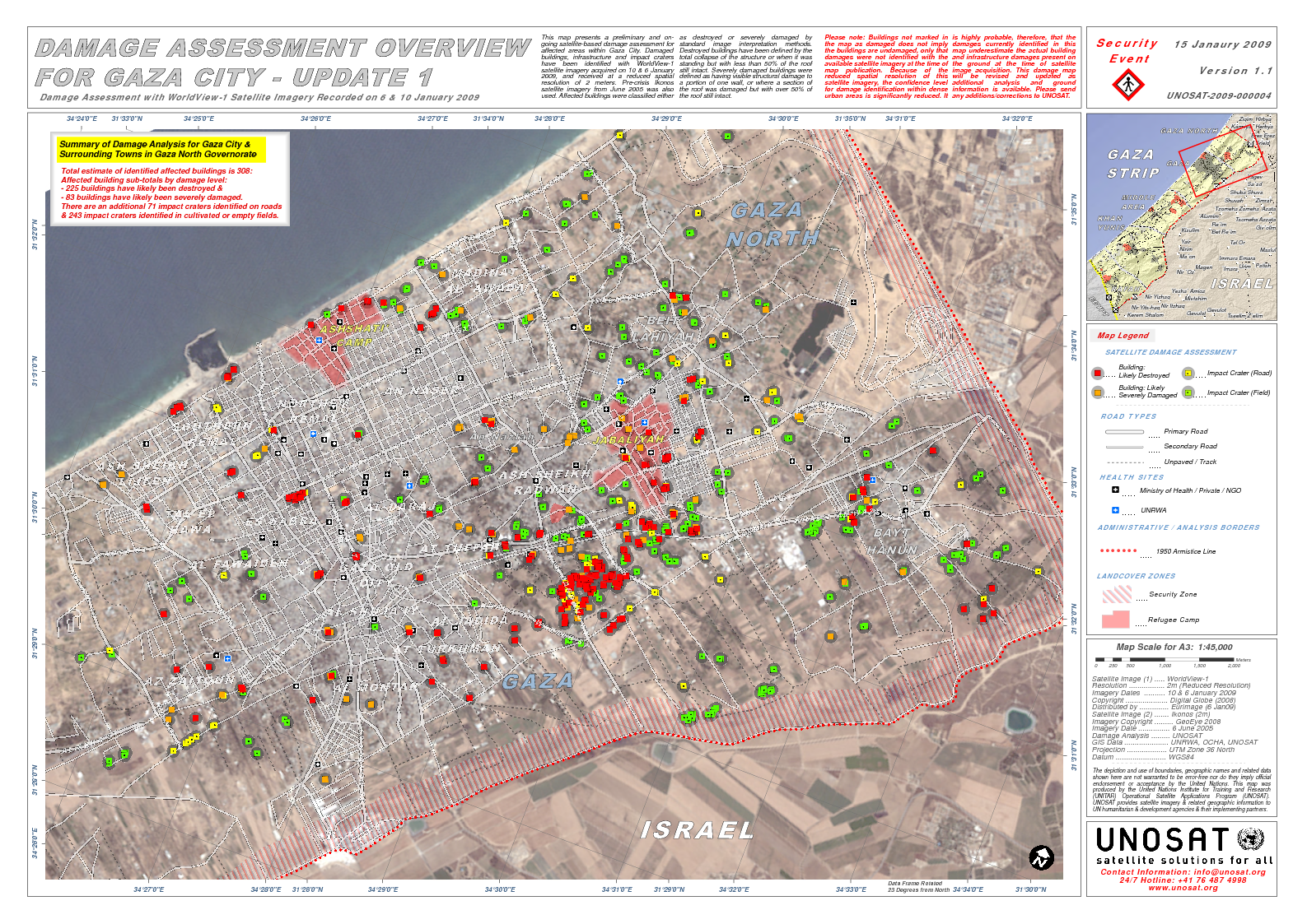
English: According to UNOSAT, "This map presents a preliminary and on-going satellite-based damage assessment for affected areas within Gaza City..satellite imagery acquired on 10 & 6 January 2009"
Source(s): Satellite Image (1) : WorldView-1 Resolution : 2m (Reduced Resolution) Imagery Dates : 10 & 6 January 2009 Copyright : Digital Globe (2008) Distributed by : Eurimage (6 Jan09) Satellite Image (2) : Ikonos (2m) Imagery Copyright : GeoEye 2008 Imagery Date : 6 June 2005 Damage Analysis : UNOSAT GIS Data : UNRWA, OCHA, GIST, UNOSAT |
| Datum | |
| Bron | http://unosat.web.cern.ch/unosat/freeproducts/Gaza/Crisis2008/UNOSAT_Gaza_WV_Damage_Overview_10Jan09_Highres_v2.pdf |
| Auteur | UNOSAT |
Licentie

|
De auteursrechthebbende van dit bestand staat iedereen toe het voor willekeurig welk doel te gebruiken, mits de auteursrechthebbende correct met naam wordt genoemd.
Heruitgave, afgeleide werken, commercieel gebruik en alle andere vormen van gebruik zijn toegestaan. |
|
|
Bestandsgeschiedenis
Klik op een datum/tijd om het bestand te zien zoals het destijds was.
| Datum/tijd | Miniatuur | Afmetingen | Gebruiker | Opmerking | |
|---|---|---|---|---|---|
| huidige versie | 10 mrt 2009 06:55 | | 1.587 × 1.123 (2,37 MB) | Falastine fee Qalby | {{Information |Description={{en|1=According to UNOSAT, "This map presents a preliminary and on-going satellite-based damage assessment for affected areas within Gaza City..satellite imagery acquired on 10 & 6 January 2009" Source(s): Satellite Image (1) |
Bestandsgebruik
Dit bestand wordt op de volgende pagina gebruikt:
Globaal bestandsgebruik
De volgende andere wiki's gebruiken dit bestand:
- Gebruikt op fi.wikipedia.org
- Gebruikt op hr.wikipedia.org
- Gebruikt op sh.wikipedia.org