
Bestand:Ireland (4440319873).jpg

Oorspronkelijk bestand (1.600 × 2.200 pixels, bestandsgrootte: 478 kB, MIME-type: image/jpeg)
| Dit is een bestand van Wikimedia Commons. Onderstaande beschrijving komt van de beschrijving van het bestand daar. |
.jpg)
Beschrijving
| Beschrijving |
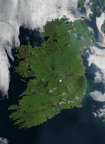
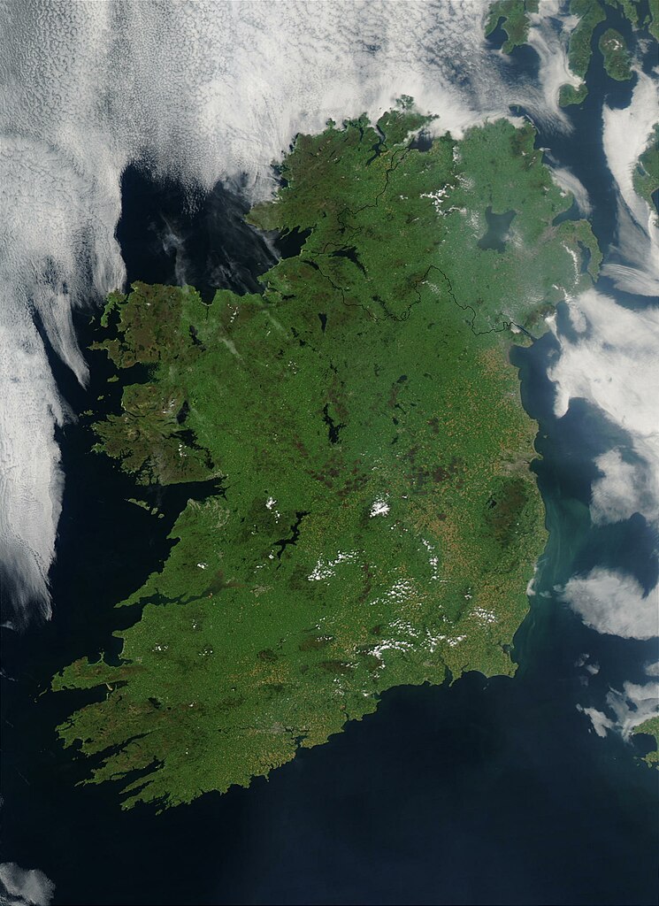
On August 7, 2003, the NASA Aqua MODIS instrument acquired this image of Ireland on the first day this summer that most of the island hasn´t been completely obscured by cloud cover. Called the Emerald Isle for a good reason, Ireland is draped in vibrant shades of green amidst the blue Atlantic Ocean and Celtic (south) and Irish (east) Seas. Faint ribbons of blue-green phytoplankton drift in the waters of the Celtic Sea, just south of Dublin. Dublin itself appears as a large grayish-brown spot on the Republic of Ireland´s northeastern coast. This large capital city (population 1.12 million) sits on the River Liffey, effectively splitting the city in half. Northern Ireland´s capital city, Belfast, also sits on a river: the River Lagan. This city, though its population is only a fifth of the size of Dublin´s, is also clearly visible in the image as a grayish-brown spot on the coast of the Irish Sea. Sensor Aqua/MODIS Credit Jeff Schmaltz, MODIS Rapid Response Team, NASA/GSFC
<a href="http://visibleearth.nasa.gov/view_rec.php?id=5744" rel="nofollow">visibleearth.nasa.gov/view_rec.php?id=5744</a>
Follow us on Twitter Join us on <a href="http://www.facebook.com/pages/Greenbelt-MD/NASA-Goddard/395013845897?ref=tsd" rel="nofollow">Facebook</a> |
| Datum | |
| Bron | Ireland |
| Auteur | NASA Goddard Space Flight Center from Greenbelt, MD, USA |
| Cameralocatie | | Deze en andere afbeeldingen in: OpenStreetMap |
|---|
.jpg¶ms=052.802761_N_-007.910156_E_globe:Earth_type:camera_source:Flickr_&language=nl)
Licentie
- De gebruiker mag:
- Delen – het werk kopiëren, verspreiden en doorgeven
- Remixen – afgeleide werken maken
- Onder de volgende voorwaarden:
- naamsvermelding – U moet op een gepaste manier aan naamsvermelding doen, een link naar de licentie geven, en aangeven of er wijzigingen in het werk zijn aangebracht. U mag dit op elke redelijke manier doen, maar niet zodanig dat de indruk wordt gewekt dat de licentiegever instemt met uw werk of uw gebruik van zijn werk.
| Deze afbeelding is oorspronkelijk op Flickr geplaatst door NASA Goddard Photo and Video op https://flickr.com/photos/24662369@N07/4440319873 (archiefinstelling). Dit is op 11 mei 2018 door de FlickreviewR 2-Bot beoordeeld en de licentie onder de voorwaarden van cc-by-2.0 is bevestigd. |
| Dit bestand bevindt zich in het publiek domein, omdat het gemaakt is door de NASA. In de reproductierichtlijnen van de NASA staat dat "NASA-materiaal niet beschermd wordt door auteursrecht, tenzij anders vermeld". | ||
 |
Waarschuwingen:
|
Bestandsgeschiedenis
Klik op een datum/tijd om het bestand te zien zoals het destijds was.
| Datum/tijd | Miniatuur | Afmetingen | Gebruiker | Opmerking | |
|---|---|---|---|---|---|
| huidige versie | 12 mei 2018 01:48 | | 1.600 × 2.200 (478 kB) | OceanAtoll | Transferred from Flickr via #flickr2commons |
Bestandsgebruik
Dit bestand wordt op de volgende pagina gebruikt:
Globaal bestandsgebruik
De volgende andere wiki's gebruiken dit bestand:
- Gebruikt op eo.wikipedia.org
- Gebruikt op nds-nl.wikipedia.org
.jpg)