
Bestand:Transvaal railway map 1899.svg

Afmetingen van deze voorvertoning van het type PNG van dit SVG-bestand: 800 × 498 pixels Andere resoluties: 320 × 199 pixels | 640 × 398 pixels | 1.024 × 637 pixels | 1.280 × 796 pixels | 2.560 × 1.593 pixels | 982 × 611 pixels.
Oorspronkelijk bestand (SVG-bestand, nominaal 982 × 611 pixels, bestandsgrootte: 104 kB)
| Dit is een bestand van Wikimedia Commons. Onderstaande beschrijving komt van de beschrijving van het bestand daar. |
| Beschrijving |
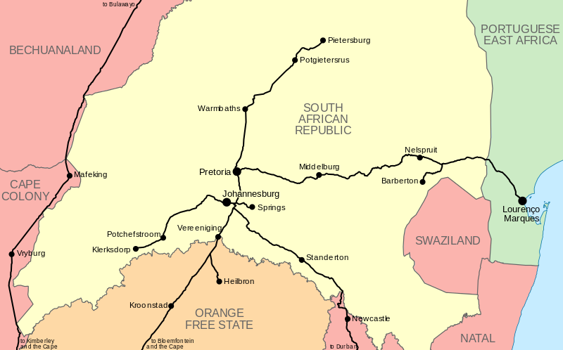
English: Map of the railway network of the en:South African Republic (Transvaal), as it stood in 1899 at the outbreak of the Anglo-Boer War. |
|||
| Datum | ||||
| Bron |
|
|||
| Auteur | Htonl | |||
| Toestemming (Hergebruik van dit bestand) |
Ik, de auteursrechthebbende van dit werk, maak het hierbij onder de volgende licenties beschikbaar: Dit bestand is gelicenseerd onder de Creative Commons Naamsvermelding-GelijkDelen 4.0 Internationaal licentie.
Dit bestand is gelicenseerd onder de Creative Commons-licentie Naamsvermelding-Gelijk delen 3.0 Unported
U mag zelf één van de licenties kiezen.
|
|||
| Andere versies | File:NZASM line map.svg |
Bestandsgeschiedenis
Klik op een datum/tijd om het bestand te zien zoals het destijds was.
| Datum/tijd | Miniatuur | Afmetingen | Gebruiker | Opmerking | |
|---|---|---|---|---|---|
| huidige versie | 29 jan 2013 23:19 | | 982 × 611 (104 kB) | Htonl | ocean colour |
| 29 jan 2013 17:50 |  | 982 × 611 (104 kB) | Htonl | remove Zululand label; it had been incorporated into Natal by 1899 | |
| 29 jan 2013 03:17 |  | 982 × 611 (105 kB) | Htonl | {{Information |Description ={{en|1=Map of the railway network of the en:South African Republic (Transvaal), as it stood in 1899 at the outbreak of the Anglo-Boer War.}} |Source =* Own work * OpenStreetMap data used for railway lines |Au... |
Bestandsgebruik
Dit bestand wordt op de volgende pagina gebruikt:
Globaal bestandsgebruik
De volgende andere wiki's gebruiken dit bestand:
- Gebruikt op de.wikipedia.org