
Bestand:Map of Israel, neighbours and occupied territories.svg

Oorspronkelijk bestand (SVG-bestand, nominaal 559 × 721 pixels, bestandsgrootte: 650 kB)
| Dit is een bestand van Wikimedia Commons. Onderstaande beschrijving komt van de beschrijving van het bestand daar. |
Beschrijving
| Beschrijving |
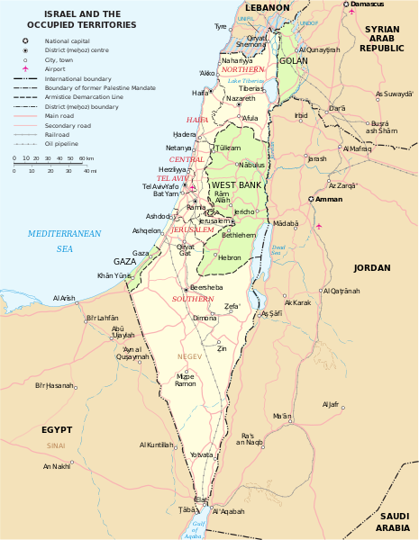
English: Map of the Middle East showing Israel, Egypt, Saudi Arabia, Jordan, Syria and Lebanon including Gaza, Golan Heights and West Bank.
العربية: خريطة دولة إسرائيل والأراضي الفلسطينية التي تشمل الضفة الغربية وقطاع غزة والجولان السوري المحتل. |
| Datum | |
| Bron | SVG extracted and edited from PDF |
| Auteur | un.org |
| Andere versies | македонски |
| SVG ontwikkeling | De broncode van dit SVG-bestand is deugdelijk. |
Licentie
| This image is a map derived from a United Nations map.
Unless stated otherwise, UN maps are to be considered in the public domain. This applies worldwide. UN maps are, in principle, open source material and you can use them in your work or for making your own map. UN requests however that you delete the UN name, logo and reference number upon any modification to the map. Content of your map will be your responsibility. You can state in your publication, if you wish, something like: based on UN map … (map name, map number, revision number and date). See: Geospatial Information Section. And: Geospatial, location data for a better world. |
 |
| Ik, de auteursrechthebbende van dit werk, geef dit werk vrij in het publieke domein. Dit is wereldwijd van toepassing. In sommige landen is dit wettelijk niet mogelijk; in die gevallen geldt: Ik sta iedereen toe dit werk voor eender welk doel te gebruiken, zonder enige voorwaarden, tenzij zulke voorwaarden door de wet worden voorgeschreven. |
Bestandsgeschiedenis
Klik op een datum/tijd om het bestand te zien zoals het destijds was.
| Datum/tijd | Miniatuur | Afmetingen | Gebruiker | Opmerking | |
|---|---|---|---|---|---|
| huidige versie | 7 okt 2023 18:07 | | 559 × 721 (650 kB) | LametinoWiki | File uploaded using svgtranslate tool (https://svgtranslate.toolforge.org/). Added translation for it. |
| 7 okt 2023 18:07 |  | 559 × 721 (650 kB) | LametinoWiki | File uploaded using svgtranslate tool (https://svgtranslate.toolforge.org/). Added translation for it. | |
| 27 dec 2022 03:49 |  | 559 × 721 (596 kB) | Wikijahnn | File uploaded using svgtranslate tool (https://svgtranslate.toolforge.org/). Added translation for ca. | |
| 27 dec 2022 03:46 |  | 559 × 721 (596 kB) | Wikijahnn | File uploaded using svgtranslate tool (https://svgtranslate.toolforge.org/). Added translation for ca. | |
| 5 mei 2018 19:09 |  | 559 × 721 (540 kB) | FrankieF | Reverted to version as of 23:22, 5 March 2018 (UTC). Replaces a bad and blurred map without distance meter to a crisp and clear map. | |
| 10 mrt 2018 20:47 |  | 559 × 721 (285 kB) | Eric's son | The last version is outdated and factually incorrect. Reverted to version as of 21:50, 26 February 2018 (UTC) | |
| 6 mrt 2018 01:22 |  | 559 × 721 (540 kB) | Nableezy | Reverted to version as of 16:20, 12 December 2011 (UTC) make a different map, dont replace every other with this one | |
| 26 feb 2018 23:50 |  | 559 × 721 (285 kB) | Eric's son | small graphic fixes | |
| 20 feb 2018 00:24 |  | 559 × 721 (259 kB) | Eric's son | Adding relevant updates (evacuated UN zones), clear colored borders explained in legend. | |
| 12 dec 2011 18:20 |  | 559 × 721 (540 kB) | Ch1902 | =={{int:filedesc}}== {{Information |Description={{en|1=Map of the Middle East showing Israel, Egypt, Saudi Arabia, Jordan, Syria and Lebanon including Gaza, Golan Heights and West Bank.}} |Source=SVG extracted and edited from [http://www.un.org/Depts/Car |
Bestandsgebruik
Dit bestand wordt op de volgende pagina gebruikt:
Globaal bestandsgebruik
De volgende andere wiki's gebruiken dit bestand:
- Gebruikt op ary.wikipedia.org
- Gebruikt op azb.wikipedia.org
- Gebruikt op bxr.wikipedia.org
- Gebruikt op ca.wikipedia.org
- Gebruikt op da.wikipedia.org
- Gebruikt op en.wikipedia.org
- Gebruikt op ga.wikipedia.org
- Gebruikt op gl.wikipedia.org
- Gebruikt op hy.wikipedia.org
- Gebruikt op it.wikipedia.org
- Gebruikt op kn.wikipedia.org
- Gebruikt op ko.wikipedia.org
- Gebruikt op pap.wikipedia.org
- Gebruikt op pnb.wikipedia.org
- Gebruikt op ru.wikipedia.org
- Gebruikt op sr.wikipedia.org
- Gebruikt op sv.wikipedia.org
- Gebruikt op www.wikidata.org