
Bestand:NederlandProvincie.jpg

Geen hogere resolutie beschikbaar.
NederlandProvincie.jpg (462 × 568 pixels, bestandsgrootte: 90 kB, MIME-type: image/jpeg)
| Dit is een bestand van Wikimedia Commons. Onderstaande beschrijving komt van de beschrijving van het bestand daar. |
Beschrijving
| Beschrijving |
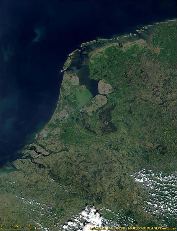
Nederlands: Nederland en de indeling in provincies.
Samengesteld door Ed Stevenhagen 13 jul 2005 17:14 (CEST) Satellietopname: Nederland uit de ruimte van modis.gsfc.nasa.gov/MODIS/IMAGE_GALLERY/MODIS1000097_md.jpg NASA Terms of Use For all non-private uses, NASA's Terms Of Use are as follows:
Visible Earth Addendum Beyond the NASA Terms, the Visible Earth team requests, but does not require:
|
| Datum | 13 juli 2005 (originele uploaddatum) |
| Bron | Transferred from nl.wikipedia |
| Auteur | Original uploader was Ed Stevenhagen at nl.wikipedia |
| Toestemming (Hergebruik van dit bestand) |
This image is in the public domain; PD-NASA. |
Licentie
| Dit bestand bevindt zich in het publiek domein, omdat het gemaakt is door de NASA. In de reproductierichtlijnen van de NASA staat dat "NASA-materiaal niet beschermd wordt door auteursrecht, tenzij anders vermeld". | ||
 |
Waarschuwingen:
|

|
Textual information (e.g. timestamp) once visible in the image itself has been moved into the image metadata and/or image description page. This makes the image easier to reuse and more language-neutral, and makes the text easier to process and search for. Commons discourages placing visible textual information in images. All licenses accepted on Commons permit this type of modification as a derivative work.
If attribution information were removed and the image is not public domain, replace this tag with {{Attribution metadata from licensed image}}.
|
Oorspronkelijk uploadlogboek
De oorspronkelijke beschrijving van deze afbeelding stond hier. Alle volgende gebruikersnamen verwijzen naar nl.wikipedia.
- 2006-01-22 22:39 Ed Stevenhagen 462×568×8 (74968 bytes) Zie oorspronkelijke beschrijving. Aanpassing Markerwaard
- 2005-07-13 15:14 Ed Stevenhagen 462×568×8 (168190 bytes) Nederland en de indeling in provincies. Samengesteld door ~~~~ Satellietopname: Nederland uit de ruimte van [http://modis.gsfc.nasa.gov/MODIS/IMAGE_GALLERY/MODIS1000097_md.jpg modis.gsfc.nasa.gov/MODIS/IMAGE_GALLERY/MODIS1000097_md.jpg] NASA Terms of Use
Bestandsgeschiedenis
Klik op een datum/tijd om het bestand te zien zoals het destijds was.
| Datum/tijd | Miniatuur | Afmetingen | Gebruiker | Opmerking | |
|---|---|---|---|---|---|
| huidige versie | 4 aug 2008 05:24 | | 462 × 568 (90 kB) | Jarekt | Removed 4 watermarks |
| 3 aug 2008 07:02 |  | 462 × 546 (74 kB) | Jarekt | {{Information |Description=removed watermark |Source= |Date= |Author= |Permission= |other_versions= }} | |
| 6 mrt 2008 10:30 |  | 462 × 568 (73 kB) | File Upload Bot (Magnus Manske) | {{BotMoveToCommons|nl.wikipedia}} {{Information |Description={{nl|Nederland en de indeling in provincies. Samengesteld door Ed Stevenhagen 13 jul 2005 17:14 (CEST) Satellietopname: Nederland uit de ruimte van [http://modi |
Bestandsgebruik
Dit bestand wordt op de volgende pagina gebruikt:
Globaal bestandsgebruik
De volgende andere wiki's gebruiken dit bestand:
- Gebruikt op zh.wiktionary.org