
Bestand:2008 Atlantic hurricane season map.png

Grootte van deze voorvertoning: 776 × 600 pixels. Andere resoluties: 311 × 240 pixels | 621 × 480 pixels | 994 × 768 pixels | 1.320 × 1.020 pixels.
Oorspronkelijk bestand (1.320 × 1.020 pixels, bestandsgrootte: 1,26 MB, MIME-type: image/png)
| Dit is een bestand van Wikimedia Commons. Onderstaande beschrijving komt van de beschrijving van het bestand daar. |
Beschrijving
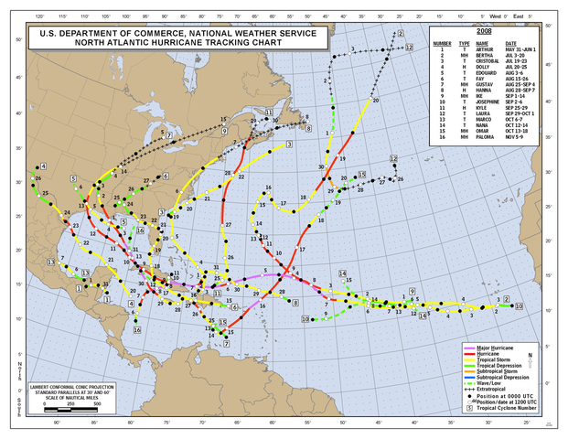
| Beschrijving | Season summary provided by NOAA of the 2008 Atlantic hurricane season. |
| Datum | Unknown, most likely the year of the season. |
| Bron | Originally from http://www.nhc.noaa.gov/tracks/ |
| Auteur | National Hurricane Center |
- For usage instructions and information about updating this image, see here.
- This page is a transculsion the Commons template {{Atlantic hurricane season map}}, in the form {{Atlantic hurricane season map|YYYY}} where YYYY is the year of the season.
Licentie
Deze afbeelding is in het publiek domein omdat het materiaal bevat dat oorspronkelijk van de National Oceanic and Atmospheric Administration kwam in de Verenigde Staten en genomen of gemaakt is tijdens de officiële werkzaamheden van een werknemer.
|
Bestandsgeschiedenis
Klik op een datum/tijd om het bestand te zien zoals het destijds was.
| Datum/tijd | Miniatuur | Afmetingen | Gebruiker | Opmerking | |
|---|---|---|---|---|---|
| huidige versie | 26 feb 2009 03:45 | | 1.320 × 1.020 (1,26 MB) | Potapych | {{Atlantic hurricane season map|2008}} <!--{{ImageUpload|basic}}--> |
Bestandsgebruik
Dit bestand wordt op de volgende pagina gebruikt:
Globaal bestandsgebruik
De volgende andere wiki's gebruiken dit bestand:
- Gebruikt op en.wikipedia.org
- Gebruikt op fi.wikipedia.org
- Gebruikt op www.wikidata.org