
Bestand:2011 Lorca earthquake intensity.jpg

Grootte van deze voorvertoning: 510 × 599 pixels. Andere resoluties: 204 × 240 pixels | 612 × 719 pixels.
Oorspronkelijk bestand (612 × 719 pixels, bestandsgrootte: 93 kB, MIME-type: image/jpeg)
| Dit is een bestand van Wikimedia Commons. Onderstaande beschrijving komt van de beschrijving van het bestand daar. |
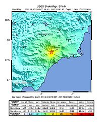
| Beschrijving |
English: Lorca earthquake intensity map |
|||
| Datum | ||||
| Bron | https://earthquake.usgs.gov/earthquakes/shakemap/global/shake/c0003c5s/ | |||
| Auteur | USGS | |||
| Toestemming (Hergebruik van dit bestand) |
|
Bestandsgeschiedenis
Klik op een datum/tijd om het bestand te zien zoals het destijds was.
| Datum/tijd | Miniatuur | Afmetingen | Gebruiker | Opmerking | |
|---|---|---|---|---|---|
| huidige versie | 13 mei 2011 16:37 | | 612 × 719 (93 kB) | S99 | {{Information |Description ={{en|1=Lorca earthquake intensity map}} |Source =http://earthquake.usgs.gov/earthquakes/shakemap/global/shake/c0003c5s/ |Author =USGS |Date =2011-05-11 |Permission ={{PD-USGov-USGS}} |other_vers |
Bestandsgebruik
Dit bestand wordt op de volgende pagina gebruikt:
Globaal bestandsgebruik
De volgende andere wiki's gebruiken dit bestand:
- Gebruikt op azb.wikipedia.org
- Gebruikt op az.wikipedia.org
- Gebruikt op ca.wikipedia.org
- Gebruikt op cs.wikipedia.org
- Gebruikt op de.wikipedia.org
- Gebruikt op el.wikipedia.org
- Gebruikt op en.wikipedia.org
- Gebruikt op es.wikipedia.org
- Gebruikt op fr.wikipedia.org
- Gebruikt op gl.wikipedia.org
- Gebruikt op hu.wikipedia.org
- Gebruikt op it.wikipedia.org
- Gebruikt op ja.wikipedia.org
- Gebruikt op pl.wikipedia.org
- Gebruikt op zh.wikipedia.org