
Bestand:Atbara river map.jpg

Grootte van deze voorvertoning: 800 × 466 pixels. Andere resoluties: 320 × 186 pixels | 640 × 372 pixels | 1.141 × 664 pixels.
Oorspronkelijk bestand (1.141 × 664 pixels, bestandsgrootte: 198 kB, MIME-type: image/jpeg)
| Dit is een bestand van Wikimedia Commons. Onderstaande beschrijving komt van de beschrijving van het bestand daar. |
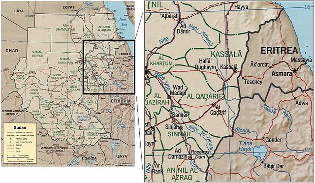
The Atbara river, in Sudan and Eritrea. Source: image:Sudan political map 2000.jpg
CIA map of Sudan from 2000
http://hdl.loc.gov/loc.gmd/g8310.ct001564
| This image is a work of a Central Intelligence Agency employee, taken or made as part of that person's official duties. As a Work of the United States Government, this image or media is in the public domain in the United States.
|

|
Bestandsgeschiedenis
Klik op een datum/tijd om het bestand te zien zoals het destijds was.
| Datum/tijd | Miniatuur | Afmetingen | Gebruiker | Opmerking | |
|---|---|---|---|---|---|
| huidige versie | 22 sep 2006 14:26 | | 1.141 × 664 (198 kB) | Laur2ro | The Atbara river, in Sudan and Eritrea. Source: image:Sudan political map 2000.jpg CIA map of Sudan from 2000 http://hdl.loc.gov/loc.gmd/g8310.ct001564 {{PD-USGov-CIA}} Category:Maps of Sudan |
Bestandsgebruik
Dit bestand wordt op de volgende pagina gebruikt:
Globaal bestandsgebruik
De volgende andere wiki's gebruiken dit bestand:
- Gebruikt op ar.wikipedia.org
- Gebruikt op az.wikipedia.org
- Gebruikt op be.wikipedia.org
- Gebruikt op ca.wikipedia.org
- Gebruikt op ceb.wikipedia.org
- Gebruikt op cs.wikipedia.org
- Gebruikt op da.wikipedia.org
- Gebruikt op de.wikipedia.org
- Gebruikt op es.wikipedia.org
- Gebruikt op et.wikipedia.org
- Gebruikt op eu.wikipedia.org
- Gebruikt op fi.wikipedia.org
- Gebruikt op fr.wikipedia.org
- Gebruikt op he.wikipedia.org
- Gebruikt op hu.wikipedia.org
- Gebruikt op it.wikipedia.org
- Gebruikt op ml.wikipedia.org
- Gebruikt op pl.wikipedia.org
- Gebruikt op pt.wikipedia.org
- Gebruikt op ro.wikipedia.org
- Gebruikt op ru.wikipedia.org
- Gebruikt op sh.wikipedia.org
- Gebruikt op uk.wikipedia.org
- Gebruikt op uz.wikipedia.org
- Gebruikt op www.wikidata.org
- Gebruikt op xmf.wikipedia.org
- Gebruikt op zh.wikipedia.org