
Bestand:BD Map admin.svg

Afmetingen van deze voorvertoning van het type PNG van dit SVG-bestand: 429 × 599 pixels Andere resoluties: 172 × 240 pixels | 344 × 480 pixels | 550 × 768 pixels | 733 × 1.024 pixels | 1.466 × 2.048 pixels | 1.531 × 2.138 pixels.
Oorspronkelijk bestand (SVG-bestand, nominaal 1.531 × 2.138 pixels, bestandsgrootte: 100 kB)
| Dit is een bestand van Wikimedia Commons. Onderstaande beschrijving komt van de beschrijving van het bestand daar. |
Beschrijving
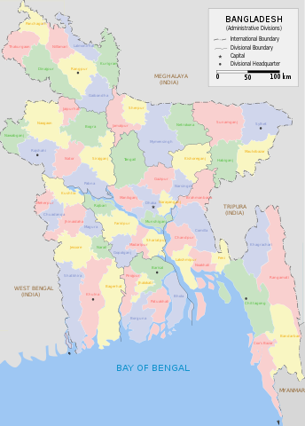
| Beschrijving | Administrative Map of Bangladesh |
| Datum | |
| Bron | Eigen werk |
| Auteur | Armanaziz |
| Andere versies |
|
| SVG ontwikkeling |


While creating this map I have drawn inspiration and reference from works of Rarelibra (here) and Usingha (here) and several online maps:LGED, GoB archief kopie op de Wayback Machine, Banglapedia. Armanaziz 08:41, 30 July 2007 (UTC)
Licentie
I, Armanaziz, de auteursrechthebbende van dit werk, maakt het hierbij onder de volgende licenties beschikbaar:

|
Toestemming wordt verleend voor het kopiëren, verspreiden en/of wijzigen van dit document onder de voorwaarden van de GNU-licentie voor vrije documentatie, versie 1.2 of enige latere versie als gepubliceerd door de Free Software Foundation; zonder Invariant Sections, zonder Front-Cover Texts, en zonder Back-Cover Texts. Een kopie van de licentie is opgenomen in de sectie GNU-licentie voor vrije documentatie. |
| Dit bestand is gelicenseerd onder de Creative Commons-licentie Naamsvermelding-Gelijk delen 3.0 Unported | ||
| Naamsvermelding: I, Armanaziz | ||
| ||
| Deze licentietag is toegevoegd aan dit bestand in verband met de GFDL licentie-update. |
Dit bestand is gelicenseerd onder de Creative Commons-licentie Naamsvermelding 2.5 Unported
Naamsvermelding: I, Armanaziz
- De gebruiker mag:
- Delen – het werk kopiëren, verspreiden en doorgeven
- Remixen – afgeleide werken maken
- Onder de volgende voorwaarden:
- naamsvermelding – U moet op een gepaste manier aan naamsvermelding doen, een link naar de licentie geven, en aangeven of er wijzigingen in het werk zijn aangebracht. U mag dit op elke redelijke manier doen, maar niet zodanig dat de indruk wordt gewekt dat de licentiegever instemt met uw werk of uw gebruik van zijn werk.
U mag zelf één van de licenties kiezen.
Bestandsgeschiedenis
Klik op een datum/tijd om het bestand te zien zoals het destijds was.
| Datum/tijd | Miniatuur | Afmetingen | Gebruiker | Opmerking | |
|---|---|---|---|---|---|
| huidige versie | 14 jan 2023 13:45 | | 1.531 × 2.138 (100 kB) | Rohonk1 | Added the Division of Mymensingh |
| 21 okt 2014 10:25 |  | 1.531 × 2.138 (94 kB) | Nafsadh | border color | |
| 21 okt 2014 10:22 |  | 1.531 × 2.138 (94 kB) | Nafsadh | outside color | |
| 17 dec 2013 07:19 |  | 1.531 × 2.138 (150 kB) | Wereldburger758 | added Divisional Boundary for Rangpur Division & added Bullet ( • ) for Rangpur District | |
| 30 jul 2007 10:41 |  | 1.531 × 2.138 (208 kB) | Armanaziz | {{Information |Description=Administrative Map of Bangladesh |Source=self-made |Date=2007-07-30 |Author= Armanaziz }} While creating this map I have drawn inspiration and reference from works of Rarelibra ([[:Image:Ba |
Bestandsgebruik
Dit bestand wordt op de volgende 2 pagina's gebruikt:
Globaal bestandsgebruik
De volgende andere wiki's gebruiken dit bestand:
- Gebruikt op ar.wikipedia.org
- Gebruikt op azb.wikipedia.org
- Gebruikt op el.wikipedia.org
- Gebruikt op en.wikipedia.org
- Gebruikt op es.wikipedia.org
- Gebruikt op fa.wikipedia.org
- Gebruikt op fr.wikipedia.org
- Gebruikt op ja.wikipedia.org
- Gebruikt op ka.wikipedia.org
- Gebruikt op ko.wikipedia.org
- Gebruikt op ne.wikipedia.org
- Gebruikt op new.wikipedia.org
- Gebruikt op pa.wikipedia.org
- Gebruikt op pnb.wikipedia.org
- Gebruikt op pt.wikipedia.org
- Gebruikt op ru.wikipedia.org
- Gebruikt op simple.wikipedia.org
- Gebruikt op su.wikipedia.org
- Gebruikt op uk.wikipedia.org
- Gebruikt op ur.wikipedia.org
- Gebruikt op zh.wikipedia.org