
Bestand:Baelen Liège Belgium Map.png
Geen hogere resolutie beschikbaar.
Baelen_Liège_Belgium_Map.png (290 × 220 pixels, bestandsgrootte: 5 kB, MIME-type: image/png)
| Dit is een bestand van Wikimedia Commons. Onderstaande beschrijving komt van de beschrijving van het bestand daar. |

|
Bestand:Baelen Liège Belgium Map.svg is een vectorversie van dit bestand. Indien niet van slechtere kwaliteit dient deze gebruikt te worden in plaats van deze rasterafbeelding.
File:Baelen Liège Belgium Map.png → File:Baelen Liège Belgium Map.svg
Zie Help:SVG voor meer informatie. |
 |
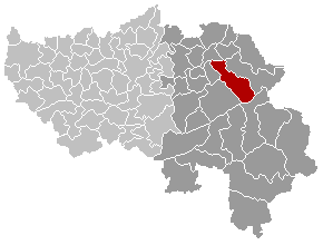
Maps, municipality belgium Baelen
| Dit werk vrijgegeven in het publieke domein door de auteur, LennartBolks. Dit is wereldwijd van toepassing. In sommige landen is dit wettelijk niet mogelijk; in die gevallen geldt: |
FR; Carte indiquant la localisation de la commune de Baelen dans la Province de Liège.
EN; Map from w:nl:Gebruiker:LennartBolks/kaartenhoekje in Public Domain by the Author choice.
Bestandsgeschiedenis
Klik op een datum/tijd om het bestand te zien zoals het destijds was.
| Datum/tijd | Miniatuur | Afmetingen | Gebruiker | Opmerking | |
|---|---|---|---|---|---|
| huidige versie | 6 sep 2008 16:44 | | 290 × 220 (5 kB) | Ludger1961 | |
| 21 mrt 2005 20:33 |  | 290 × 220 (5 kB) | Srtxg | Maps, municipality belgium Baelen {{PD}} FR; Carte indiquant la localisation de la commune de Baelen dans la Province de Liège. EN; Map from w:nl:Gebruiker:LennartBolks/kaartenhoekje in Public Domain by the Author choice. [[Category:Maps of province |
Bestandsgebruik
Geen enkele pagina gebruikt dit bestand.