
Bestand:Bananal-Island-North-End-Landsat-25-07-1992.png

Grootte van deze voorvertoning: 600 × 600 pixels. Andere resoluties: 240 × 240 pixels | 480 × 480 pixels | 768 × 768 pixels | 1.024 × 1.024 pixels.
Oorspronkelijk bestand (1.024 × 1.024 pixels, bestandsgrootte: 610 kB, MIME-type: image/png)
| Dit is een bestand van Wikimedia Commons. Onderstaande beschrijving komt van de beschrijving van het bestand daar. |
Beschrijving
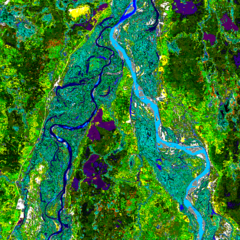
| Beschrijving | Landsat image of the northern end of Bananal Island, Brazil |
| Datum | |
| Bron | Landsat http://www.geog.ucsb.edu/~rivers/sa/bananal-web/cluster50.gif |
| Auteur | Landsat 5, US Government |
| Toestemming (Hergebruik van dit bestand) |
Public Domain |
Licentie
Deze afbeelding is in het publiek domein omdat het materiaal bevat dat oorspronkelijk van de National Oceanic and Atmospheric Administration kwam in de Verenigde Staten en genomen of gemaakt is tijdens de officiële werkzaamheden van een werknemer.
|
Oorspronkelijk uploadlogboek
| Datum/tijd | Afmetingen | Gebruiker | Opmerking |
|---|---|---|---|
| 15 augustus 2006, 21:25:13 | 1024 × 1024 (508177 bytes) | Bejnar (overleg · bijdragen) | {{Information |Description=Landsat image of the northern end of Bananal Island |Source=Landsat http://www.geog.ucsb.edu/~rivers/sa/bananal-web/cluster50.gif |Date= 25 July 1992 |Author= Landsat 5, US Government |Permission=Public Domain |other_versions= } |
Bestandsgeschiedenis
Klik op een datum/tijd om het bestand te zien zoals het destijds was.
| Datum/tijd | Miniatuur | Afmetingen | Gebruiker | Opmerking | |
|---|---|---|---|---|---|
| huidige versie | 23 aug 2014 12:09 | | 1.024 × 1.024 (610 kB) | GifTagger | Bot: Converting file to superior PNG file. (Source: Bananal-Island-North-End-Landsat-25-07-1992.gif). This GIF was problematic due to non-greyscale color table. |
Bestandsgebruik
Dit bestand wordt op de volgende pagina gebruikt:
Globaal bestandsgebruik
De volgende andere wiki's gebruiken dit bestand:
- Gebruikt op af.wikipedia.org
- Gebruikt op ca.wikipedia.org
- Gebruikt op cs.wikipedia.org
- Gebruikt op en.wikipedia.org
- Gebruikt op eo.wikipedia.org
- Gebruikt op es.wikipedia.org
- Gebruikt op fa.wikipedia.org
- Gebruikt op fi.wikipedia.org
- Gebruikt op gl.wikipedia.org
- Gebruikt op he.wikipedia.org
- Gebruikt op id.wikipedia.org
- Gebruikt op it.wikipedia.org
- Gebruikt op ja.wikipedia.org
- Gebruikt op ko.wikipedia.org
- Gebruikt op pl.wikipedia.org
- Gebruikt op pt.wikipedia.org
- Gebruikt op ro.wikipedia.org
- Gebruikt op sl.wikipedia.org
- Gebruikt op sr.wikipedia.org
- Gebruikt op vi.wikipedia.org
- Gebruikt op war.wikipedia.org
- Gebruikt op www.wikidata.org
- Gebruikt op zh.wikipedia.org