
Bestand:Europe biogeography countries en.svg

Afmetingen van deze voorvertoning van het type PNG van dit SVG-bestand: 800 × 564 pixels Andere resoluties: 320 × 225 pixels | 640 × 451 pixels | 1.024 × 722 pixels | 1.280 × 902 pixels | 2.560 × 1.804 pixels | 3.535 × 2.491 pixels.
Oorspronkelijk bestand (SVG-bestand, nominaal 3.535 × 2.491 pixels, bestandsgrootte: 710 kB)
| Dit is een bestand van Wikimedia Commons. Onderstaande beschrijving komt van de beschrijving van het bestand daar. |
Beschrijving
| Beschrijving |
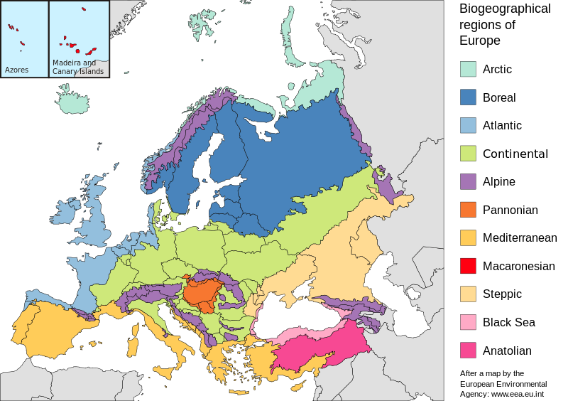
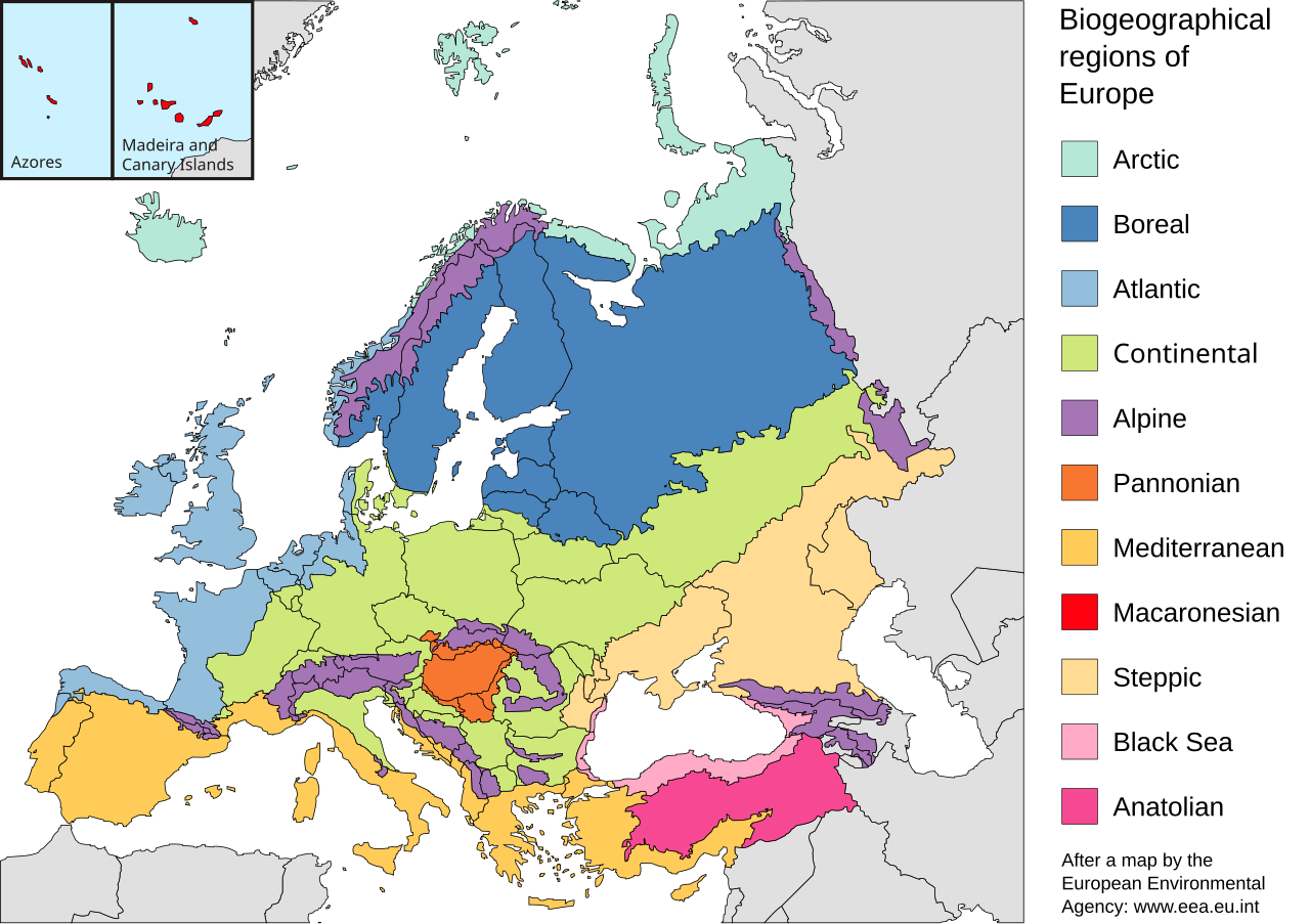
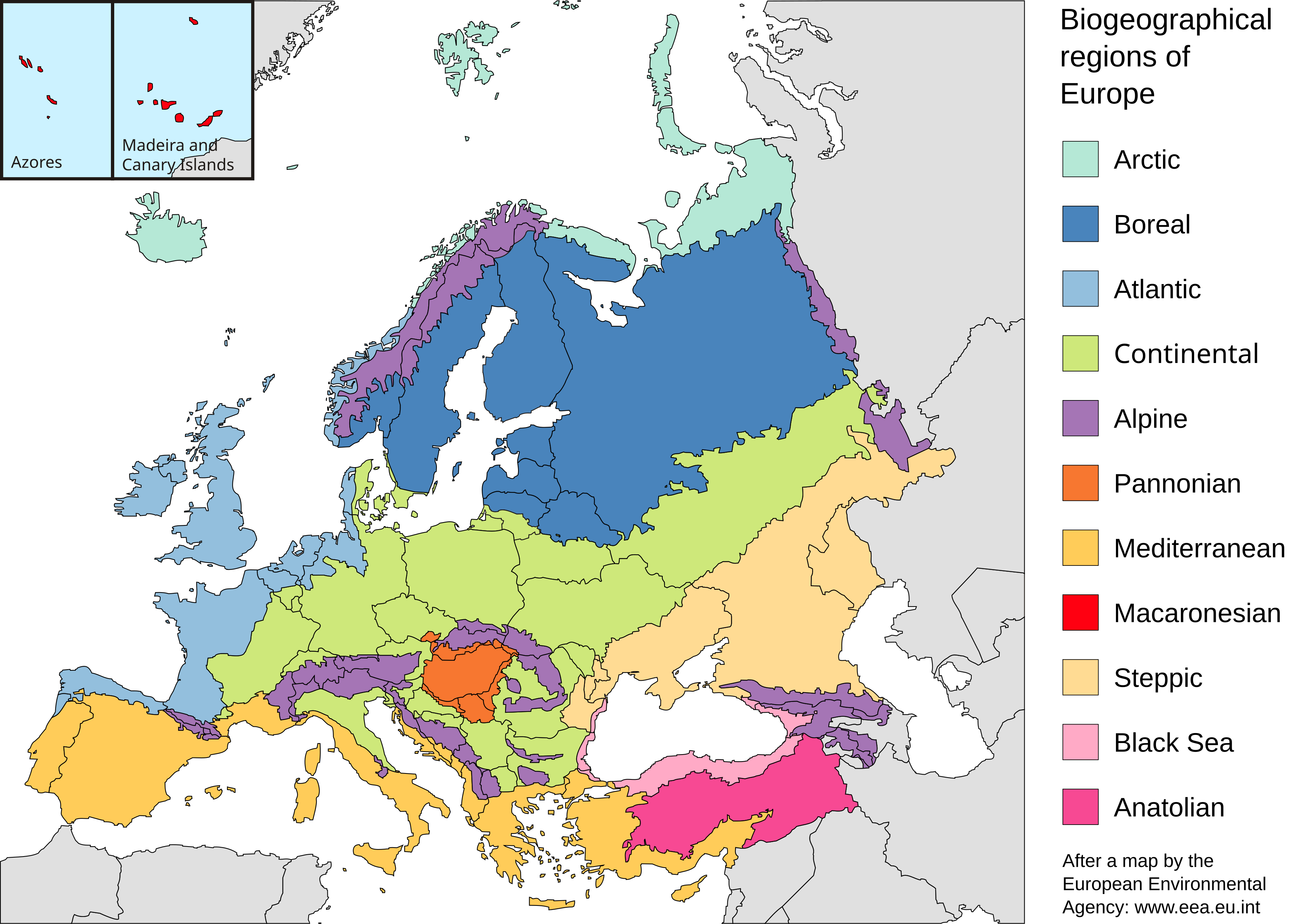
English: Map of the biogeographic regions of Europe, after EEA's map. Shows both country and biogeographical region boundaries. Legend in English. SVG format.
Español: Regiones biogeográficas de Europa.
Português: Regiões biogeográficas da Europa e regiões adjacentes.
한국어: Biogeographic regions. Biogeographic regions(Biogeographic regions.
Türkçe: Avrupa'nın Biyocoğrafik Bölgeleri (Türkiye'nin Asya kısmı da dahil).
Dansk: Pannonisk klima er her angivet med orange farve, der dækker dele af Slovakiet, Østrig, Serbien og Rumænien samt hele Ungarn.
Galego: Rexións bioxeográficas de Europa.
Norsk bokmål: Biogeografiske områder i Europa.
Norsk nynorsk: Biogeografiske område i Europa.
پښتو: Biogeographic regions of Europe.
Mirandés: Regiones biogeográficas de la Ouropa. |
| Datum | |
| Bron | Made with Inkscape from Image:Biogeographical Regions Europe - Map (intl).png by the European Environmental Agency |
| Auteur | Júlio Reis |
| Andere versies |
Regions only: Image:Europe biogeography regions.svg; blank map: Image:Europe biogeography blank.svg  |
.png)
Licentie
Dit bestand is gelicenseerd onder de Creative Commons-licentie Naamsvermelding-Gelijk delen 3.0 Unported
- De gebruiker mag:
- Delen – het werk kopiëren, verspreiden en doorgeven
- Remixen – afgeleide werken maken
- Onder de volgende voorwaarden:
- naamsvermelding – U moet op een gepaste manier aan naamsvermelding doen, een link naar de licentie geven, en aangeven of er wijzigingen in het werk zijn aangebracht. U mag dit op elke redelijke manier doen, maar niet zodanig dat de indruk wordt gewekt dat de licentiegever instemt met uw werk of uw gebruik van zijn werk.
- Gelijk delen – Als u het werk heeft geremixt, veranderd, of erop heeft voortgebouwd, moet u het gewijzigde materiaal verspreiden onder dezelfde licentie als het oorspronkelijke werk, of een daarmee compatibele licentie.
Bestandsgeschiedenis
Klik op een datum/tijd om het bestand te zien zoals het destijds was.
| Datum/tijd | Miniatuur | Afmetingen | Gebruiker | Opmerking | |
|---|---|---|---|---|---|
| huidige versie | 19 jul 2010 22:41 | | 3.535 × 2.491 (710 kB) | Malus Catulus | Changed according graphic lab request: removed frame, hopefully fixed text, fixed some other stuff |
| 23 mei 2006 12:48 |  | 3.600 × 2.610 (876 kB) | Tintazul | {{Tintazul| |Description=Map of the biogeographic regions of Europe, after EEA's map. Shows both country and biogeographical region boundaries. Legend in English. SVG format. |Date=20 May 2006 |Source=Made with Inkscape from [[:Image:Biogeographical Regi |
Bestandsgebruik
Dit bestand wordt op de volgende 2 pagina's gebruikt:
Globaal bestandsgebruik
De volgende andere wiki's gebruiken dit bestand:
- Gebruikt op ar.wikipedia.org
- Gebruikt op azb.wikipedia.org
- Gebruikt op az.wikipedia.org
- Gebruikt op beta.wikiversity.org
- Gebruikt op bn.wikipedia.org
- Gebruikt op bs.wikipedia.org
- Gebruikt op cs.wikipedia.org
- Gebruikt op da.wikipedia.org
- Gebruikt op el.wikipedia.org
- Gebruikt op en.wikipedia.org
- Geography of Armenia
- Europe
- Biogeography
- Pannonian Basin
- Template talk:Greek diaspora
- User:Engram
- Fauna of Europe
- User:Whytecypress/UserboxCaucasian
- Portal:Maps/Maps/Geographic
- User talk:BadYodels
- Portal:Maps/Maps/Geographic/6
- User:Kaarel/sandbox/Fauna of Europe
- List of butterflies of Europe
- Mediterranean Biogeographic Region
- Arctic Biogeographic Region
- Boreal Biogeographic Region
- Biogeographic regions of Europe
- Atlantic Biogeographic Region
- Continental Biogeographic Region
- Anatolian Biogeographic Region
- Black Sea Biogeographic Region
- Macaronesian Biogeographic Region
- Alpine Biogeographic Region
- Pannonian Biogeographic Region
- Steppic Biogeographic Region
- Gebruikt op en.wikiversity.org
- Gebruikt op eo.wikipedia.org
- Gebruikt op es.wikipedia.org
- Gebruikt op fa.wikipedia.org
- Gebruikt op ga.wikipedia.org
- Gebruikt op gl.wikipedia.org
- Gebruikt op hy.wikipedia.org
- Gebruikt op ja.wikipedia.org
Globaal gebruik van dit bestand bekijken.