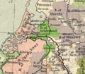
Bestand:Gelre1477.png

Grootte van deze voorvertoning: 688 × 600 pixels. Andere resoluties: 275 × 240 pixels | 551 × 480 pixels | 772 × 673 pixels.
Oorspronkelijk bestand (772 × 673 pixels, bestandsgrootte: 937 kB, MIME-type: image/png)
Bestandsgeschiedenis
Klik op een datum/tijd om het bestand te zien zoals het destijds was.
| Datum/tijd | Miniatuur | Afmetingen | Gebruiker | Opmerking | |
|---|---|---|---|---|---|
| huidige versie | 13 mei 2011 22:13 |  | 772 × 673 (937 kB) | Hans Erren | corrected southern boundary to include ambt montfort. Reloaded original perry castaneda map, Rotated to true north, adjusted gamma, sharpened, fill coloured area in more pastel tone. |
| 25 feb 2006 21:02 |  | 334 × 277 (183 kB) | Eugene van der Pijll | ||
| 25 feb 2006 20:20 |  | 334 × 277 (165 kB) | Odejea | == Description == Carte du duché de Gueldre, en 1477 Origine : * collection de cartes de l'Université du Texas (http://www.lib.utexas.edu/maps/). Ces cartes sont dans le domaine public (http://www.lib.utexas.edu/maps/faq.html#3.html). * uploadé sur W |
Bestandsgebruik
Dit bestand wordt op de volgende 9 pagina's gebruikt:
Globaal bestandsgebruik
De volgende andere wiki's gebruiken dit bestand:
- Gebruikt op af.wikipedia.org
- Gebruikt op ar.wikipedia.org
- Gebruikt op br.wikipedia.org
- Gebruikt op ca.wikipedia.org
- Gebruikt op da.wikipedia.org
- Gebruikt op de.wikipedia.org
- Gebruikt op en.wikipedia.org
- Gebruikt op et.wikipedia.org
- Gebruikt op fr.wikipedia.org
- Gebruikt op he.wikipedia.org
- Gebruikt op hu.wikibooks.org
- Gebruikt op it.wikipedia.org
- Gebruikt op li.wikipedia.org
- Gebruikt op nds-nl.wikipedia.org
- Gebruikt op nn.wikipedia.org
- Gebruikt op no.wikipedia.org
- Gebruikt op pl.wikipedia.org
- Gebruikt op pt.wikipedia.org
- Gebruikt op ru.wikipedia.org
- Gebruikt op th.wikipedia.org

