
Bestand:Ile tromelin 76.jpg

Geen hogere resolutie beschikbaar.
Ile_tromelin_76.jpg (370 × 336 pixels, bestandsgrootte: 28 kB, MIME-type: image/jpeg)
| Dit is een bestand van Wikimedia Commons. Onderstaande beschrijving komt van de beschrijving van het bestand daar. |
Beschrijving
| Beschrijving |
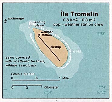
Deutsch: Karte der Insel Tromelin im Indischen Ozean
English: Map of Tromelin Island in the Indian Ocean
Français : Carte d'île Tromelin dans l’océan Indien |
| Datum | |
| Bron | http://www.lib.utexas.edu/maps/islands_oceans_poles/ile_tromelin_76.jpg |
| Auteur | Taken from Perry-Castañeda Library (PCL), originally from CIA Indian Ocean Atlas |
| Toestemming (Hergebruik van dit bestand) |
PD, see licensing |
Licentie
| This image is a work of a Central Intelligence Agency employee, taken or made as part of that person's official duties. As a Work of the United States Government, this image or media is in the public domain in the United States.
|

|
Bestandsgeschiedenis
Klik op een datum/tijd om het bestand te zien zoals het destijds was.
| Datum/tijd | Miniatuur | Afmetingen | Gebruiker | Opmerking | |
|---|---|---|---|---|---|
| huidige versie | 3 feb 2005 07:33 | | 370 × 336 (28 kB) | Dysprosia~commonswiki | {{PD-PCL|http://www.lib.utexas.edu/maps/islands_oceans_poles/ile_tromelin_76.jpg}} |
Bestandsgebruik
Dit bestand wordt op de volgende pagina gebruikt:
Globaal bestandsgebruik
De volgende andere wiki's gebruiken dit bestand:
- Gebruikt op ar.wikipedia.org
- Gebruikt op az.wikipedia.org
- Gebruikt op cs.wikipedia.org
- Gebruikt op el.wikipedia.org
- Gebruikt op en.wikivoyage.org
- Gebruikt op fi.wikipedia.org
- Gebruikt op gl.wikipedia.org
- Gebruikt op id.wikipedia.org
- Gebruikt op it.wikipedia.org
- Gebruikt op ja.wikipedia.org
- Gebruikt op ka.wikipedia.org
- Gebruikt op lij.wikipedia.org
- Gebruikt op pl.wikipedia.org
- Gebruikt op ro.wikipedia.org
- Gebruikt op ru.wikipedia.org
- Gebruikt op sv.wikipedia.org
- Gebruikt op uk.wikipedia.org
- Gebruikt op ur.wikipedia.org
- Gebruikt op vi.wikipedia.org