
Bestand:Ilemi triangle map.PNG

Grootte van deze voorvertoning: 800 × 592 pixels. Andere resoluties: 320 × 237 pixels | 640 × 473 pixels | 990 × 732 pixels.
Oorspronkelijk bestand (990 × 732 pixels, bestandsgrootte: 85 kB, MIME-type: image/png)
| Dit is een bestand van Wikimedia Commons. Onderstaande beschrijving komt van de beschrijving van het bestand daar. |
Beschrijving
| Beschrijving |
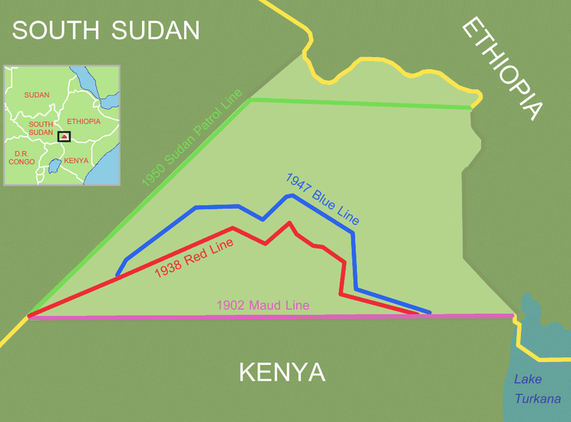
Ilemi triangle (light area), disputed area between Ethiopia, Sudan and Kenya
Reference and further information: DELIMITATION OF THE ELASTIC ILEMI TRIANGLE: PASTORAL CONFLICTS AND OFFICIAL INDIFFERENCE IN THE HORN OF AFRICA See also: satellite image |
| Datum | 24 maart 2006 (originele uploaddatum) |
| Bron | Geen machineleesbare bron opgegeven. Eigen werk aangenomen (gebaseerd op auteursrechtclaims). |
| Auteur | Geen machineleesbare auteur aanwezig. Op basis van auteursrechtclaims wordt auteur Roke~commonswiki aangenomen. |
Licentie
Ik, de auteursrechthebbende van dit werk, maak het hierbij onder de volgende licentie beschikbaar:

|
Toestemming wordt verleend voor het kopiëren, verspreiden en/of wijzigen van dit document onder de voorwaarden van de GNU-licentie voor vrije documentatie, versie 1.2 of enige latere versie als gepubliceerd door de Free Software Foundation; zonder Invariant Sections, zonder Front-Cover Texts, en zonder Back-Cover Texts. Een kopie van de licentie is opgenomen in de sectie GNU-licentie voor vrije documentatie. |
| Dit bestand is gelicenseerd onder de Creative Commons-licentie Naamsvermelding-Gelijk delen 3.0 Unported | ||
| ||
| Deze licentietag is toegevoegd aan dit bestand in verband met de GFDL licentie-update. |
Bestandsgeschiedenis
Klik op een datum/tijd om het bestand te zien zoals het destijds was.
| Datum/tijd | Miniatuur | Afmetingen | Gebruiker | Opmerking | |
|---|---|---|---|---|---|
| huidige versie | 9 jul 2011 16:00 | | 990 × 732 (85 kB) | Nicolay Sidorov | + South Sudan |
| 19 jun 2006 14:43 |  | 990 × 732 (118 kB) | Roke~commonswiki | try again, something wrong with thumbnail on WP | |
| 14 jun 2006 13:59 |  | 990 × 732 (451 kB) | Roke~commonswiki | Reverted to earlier revision | |
| 14 jun 2006 13:58 |  | 990 × 732 (46 kB) | Roke~commonswiki | version without satellite, less confusing | |
| 24 mrt 2006 04:46 |  | 990 × 732 (451 kB) | Roke~commonswiki | Ilemi triangle, disputed area between Ethiopia, Sudan and Kenya The satellite image was a Public domain image from NASA World Wind, the other information was added with Corel Painter IX Category: Kenya Category: Ethiopia Category: Sudan |
Bestandsgebruik
Dit bestand wordt op de volgende pagina gebruikt:
Globaal bestandsgebruik
De volgende andere wiki's gebruiken dit bestand:
- Gebruikt op be.wikipedia.org
- Gebruikt op ca.wikipedia.org
- Gebruikt op cs.wikipedia.org
- Gebruikt op de.wikipedia.org
- Gebruikt op en.wikipedia.org
- Gebruikt op es.wikipedia.org
- Gebruikt op fr.wikipedia.org
- Gebruikt op hi.wikipedia.org
- Gebruikt op hr.wikipedia.org
- Gebruikt op id.wikipedia.org
- Gebruikt op it.wikipedia.org
- Gebruikt op ja.wikipedia.org
- Gebruikt op ka.wikipedia.org
- Gebruikt op ko.wikipedia.org
- Gebruikt op lt.wikipedia.org
- Gebruikt op no.wikipedia.org
- Gebruikt op pl.wikipedia.org
- Gebruikt op pt.wikipedia.org
- Gebruikt op ru.wikipedia.org
- Gebruikt op so.wikipedia.org
- Gebruikt op sr.wikipedia.org
- Gebruikt op uk.wikipedia.org
- Gebruikt op zh.wikipedia.org