
Bestand:LINE21.jpg
Grootte van deze voorvertoning: 800 × 552 pixels. Andere resoluties: 320 × 221 pixels | 640 × 442 pixels | 1.000 × 690 pixels.
Oorspronkelijk bestand (1.000 × 690 pixels, bestandsgrootte: 102 kB, MIME-type: image/jpeg)
| Dit is een bestand van Wikimedia Commons. Onderstaande beschrijving komt van de beschrijving van het bestand daar. |
Beschrijving
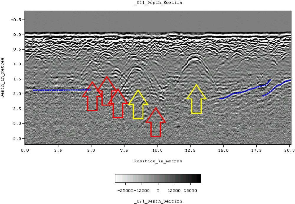
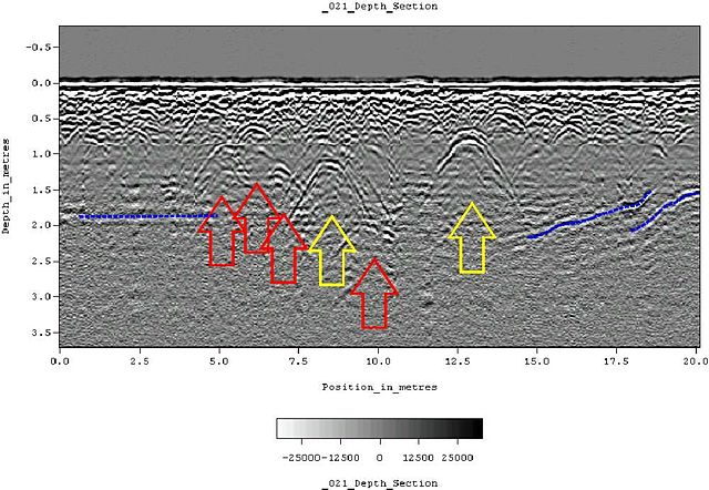
| Beschrijving | Ground-penetrating radar depth section (profile) collected on an historic cemetery in Alabama, USA. Yellow arrows indicate very distinct reflections, probably associated with human burials. "hyperbolic" reflections, appearing as an inverted U, are typically associated with discrete objects. Less distinct hyperbolic reflections are indicated by red arrows. dashed blue lines indicate horizontal and sloping reflectors, probably bedrock. The many smaller reflections near the surface are likely to be caused by tree roots. Because of the nature of the site, subsurface testing was not conducted, but these interpretations are supported by surface indications (grave markers and depressions) and with line-to-line patterning within the GPR data. |
| Datum | 11 juni 2007 (originele uploaddatum) |
| Bron | Verplaatst vanaf en.wikipedia naar Commons. |
| Auteur | Tapatio op de Engelstalige Wikipedia |
Licentie
| Dit werk vrijgegeven in het publieke domein door de auteur, Tapatio op de Engelstalige Wikipedia. Dit is wereldwijd van toepassing. In sommige landen is dit wettelijk niet mogelijk; in die gevallen geldt: Tapatio staat iedereen toe dit werk voor eender welk doel te gebruiken, zonder enige voorwaarden, tenzij zulke voorwaarden door de wet worden voorgeschreven. |
Oorspronkelijk uploadlogboek
De oorspronkelijke beschrijving van deze afbeelding stond hier. Alle volgende gebruikersnamen verwijzen naar en.wikipedia.
- 2007-06-11 05:16 Tapatio 1000×690×8 (104839 bytes) {{PD-self}}
- 2007-06-11 04:49 Tapatio 1000×690×8 (104839 bytes) Ground-penetrating radar depth section (profile) collected on an historic cemetery in Alabama, USA. Yellow arrows indicate very distinct reflections, probably associated with human burials. "Parabolic" reflections, appearing as an inverted U, are typicall
Bestandsgeschiedenis
Klik op een datum/tijd om het bestand te zien zoals het destijds was.
| Datum/tijd | Miniatuur | Afmetingen | Gebruiker | Opmerking | |
|---|---|---|---|---|---|
| huidige versie | 17 okt 2007 21:02 | | 1.000 × 690 (102 kB) | Conscious | full resolution |
| 2 okt 2007 21:22 |  | 800 × 552 (105 kB) | Rosarinagazo | Ground-penetrating radar depth section (profile) collected on an historic cemetery in Alabama, USA. Yellow arrows indicate very distinct reflections, probably associated with human burials. "hyperbolic" reflections, appearing as an inverted U, are typical |
Bestandsgebruik
Dit bestand wordt op de volgende pagina gebruikt:
Globaal bestandsgebruik
De volgende andere wiki's gebruiken dit bestand:
- Gebruikt op ar.wikipedia.org
- Gebruikt op ca.wikipedia.org
- Gebruikt op da.wikipedia.org
- Gebruikt op de.wikipedia.org
- Gebruikt op el.wikipedia.org
- Gebruikt op en.wikipedia.org
- Gebruikt op es.wikipedia.org
- Gebruikt op et.wikipedia.org
- Gebruikt op fr.wikipedia.org
- Gebruikt op he.wikipedia.org
- Gebruikt op ml.wikipedia.org
- Gebruikt op nn.wikipedia.org
- Gebruikt op no.wikipedia.org
- Gebruikt op pl.wikipedia.org
- Gebruikt op pt.wikipedia.org
- Gebruikt op sk.wikipedia.org
- Gebruikt op vi.wikipedia.org
- Gebruikt op zh.wikipedia.org