
Bestand:Landsat-farallon-de-pajaros-adjusted.png
Geen hogere resolutie beschikbaar.
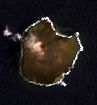
Landsat-farallon-de-pajaros-adjusted.png (97 × 105 pixels, bestandsgrootte: 40 kB, MIME-type: image/png)
| Dit is een bestand van Wikimedia Commons. Onderstaande beschrijving komt van de beschrijving van het bestand daar. |
Orthocorrected Landsat 7 image of Farallon de Pajaros, Northern Marianas. Acquired 2000-IV-4; orthocorrected by EarthSat. Source for this dataset was the Global Land Cover Facility archief kopie op de Wayback Machine. Levels have been adjusted using GIMP. This is a public domain image.
Deze afbeelding bevindt zich in het publiek domein omdat het materiaal bevat dat oorspronkelijk afkomstig is van de United States Geological Survey, een agentschap van de United States Department of the Interior. Voor meer informatie, zie het officiële USGS-auteursrechtenbeleid
|
Bestandsgeschiedenis
Klik op een datum/tijd om het bestand te zien zoals het destijds was.
| Datum/tijd | Miniatuur | Afmetingen | Gebruiker | Opmerking | |
|---|---|---|---|---|---|
| huidige versie | 14 mei 2005 20:50 | | 97 × 105 (40 kB) | Dmoews~commonswiki | Orthocorrected Landsat 7 image of Farallon de Pajaros, Northern Marianas. Acquired 2000-IV-4; orthocorrected by [http://www.earthsat.com/ EarthSat]. Source for this dataset was the [http://www.landcover.org/ Global Land Cover Facility]. Levels have bee |
Bestandsgebruik
Geen enkele pagina gebruikt dit bestand.
Globaal bestandsgebruik
De volgende andere wiki's gebruiken dit bestand:
- Gebruikt op es.wikipedia.org
- Gebruikt op gl.wikipedia.org
- Gebruikt op pt.wikipedia.org
- Gebruikt op www.wikidata.org