
Bestand:LocationKingdomAraucania.svg

Oorspronkelijk bestand (SVG-bestand, nominaal 1.000 × 500 pixels, bestandsgrootte: 987 kB)
| Dit is een bestand van Wikimedia Commons. Onderstaande beschrijving komt van de beschrijving van het bestand daar. |
Beschrijving
| Beschrijving |
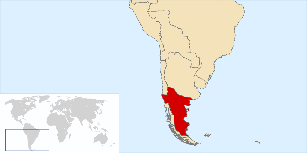
Español: Mapa localizador del Reino de la Araucanía y la Patagonia (1860-1862 aprox.).
Este mapa solo representa una idea básica de la localización del territorio reclamado por este estado no reconocido, puesto que no existe certeza exacta de las zonas reclamadas por el supuesto reino. Los mapas de otros países tampoco son representaciones fidedignas de sus fronteras en la época. La zona patagónica de Aisén, Magallanes y Tierra del Fuego aparece como un territorio distinto a Chile y Argentina al ser una zona reclamada por ambos países durante la época. La zona de la Patagonia Oriental, también reclamada por ambos, era cubierta por las reclamaciones del Reino de la Araucanía y la PatagoniaEnglish: Locator map of the Kingdom of Araucania and Patagonia (approx. 1860-1862).
The map shows only an idea of the territory disputed by the unrecognized Kingdom because there isn't any exact definition of it. Also the historical frontiers of other countries aren't accurate. The zone of Aysen, Magallanes and Tierra del Fuego islands are shown as a separate entity because it was disputed by Chile and Argentina at the time. Most of Western Patagonia (also disputed by both countries) are shown as a territory of the Kingdom. |
| Datum | |
| Bron | self-made based in Image:LocationChile.svg and Image:Continents.svg |
| Auteur | B1mbo |
Licentie

|
Toestemming wordt verleend voor het kopiëren, verspreiden en/of wijzigen van dit document onder de voorwaarden van de GNU-licentie voor vrije documentatie, versie 1.2 of enige latere versie als gepubliceerd door de Free Software Foundation; zonder Invariant Sections, zonder Front-Cover Texts, en zonder Back-Cover Texts. Een kopie van de licentie is opgenomen in de sectie GNU-licentie voor vrije documentatie. |
- De gebruiker mag:
- Delen – het werk kopiëren, verspreiden en doorgeven
- Remixen – afgeleide werken maken
- Onder de volgende voorwaarden:
- naamsvermelding – U moet op een gepaste manier aan naamsvermelding doen, een link naar de licentie geven, en aangeven of er wijzigingen in het werk zijn aangebracht. U mag dit op elke redelijke manier doen, maar niet zodanig dat de indruk wordt gewekt dat de licentiegever instemt met uw werk of uw gebruik van zijn werk.
- Gelijk delen – Als u het werk heeft geremixt, veranderd, of erop heeft voortgebouwd, moet u het gewijzigde materiaal verspreiden onder dezelfde licentie als het oorspronkelijke werk, of een daarmee compatibele licentie.
Bestandsgeschiedenis
Klik op een datum/tijd om het bestand te zien zoals het destijds was.
| Datum/tijd | Miniatuur | Afmetingen | Gebruiker | Opmerking | |
|---|---|---|---|---|---|
| huidige versie | 29 mrt 2008 04:50 | | 1.000 × 500 (987 kB) | B1mbo | {{Information |Description={{es|Mapa localizador del Reino de la Araucanía y la Patagonia (1860-1862 aprox.). Este mapa solo representa una idea básica de la localización del territorio reclamado por este |
Bestandsgebruik
Dit bestand wordt op de volgende pagina gebruikt:
Globaal bestandsgebruik
De volgende andere wiki's gebruiken dit bestand:
- Gebruikt op ar.wikipedia.org
- Gebruikt op br.wikipedia.org
- Gebruikt op ca.wikipedia.org
- Gebruikt op en.wikipedia.org
- Gebruikt op es.wikipedia.org
- Gebruikt op fi.wikipedia.org
- Gebruikt op fr.wikipedia.org
- Gebruikt op ga.wikipedia.org
- Gebruikt op gl.wikipedia.org
- Gebruikt op he.wikipedia.org
- Gebruikt op id.wikipedia.org
- Gebruikt op it.wikipedia.org
- Gebruikt op ja.wikipedia.org
- Gebruikt op ko.wikipedia.org
- Gebruikt op pt.wikipedia.org
- Gebruikt op sv.wikipedia.org
- Gebruikt op th.wikipedia.org
- Gebruikt op www.wikidata.org
- Gebruikt op zh.wikipedia.org