
Bestand:Map of Hven from copper etching of Blaeu Atlas 1663.jpg
Oorspronkelijk bestand (6.304 × 4.939 pixels, bestandsgrootte: 19,49 MB, MIME-type: image/jpeg)
| Dit is een bestand van Wikimedia Commons. Onderstaande beschrijving komt van de beschrijving van het bestand daar. |
| Beschrijving |
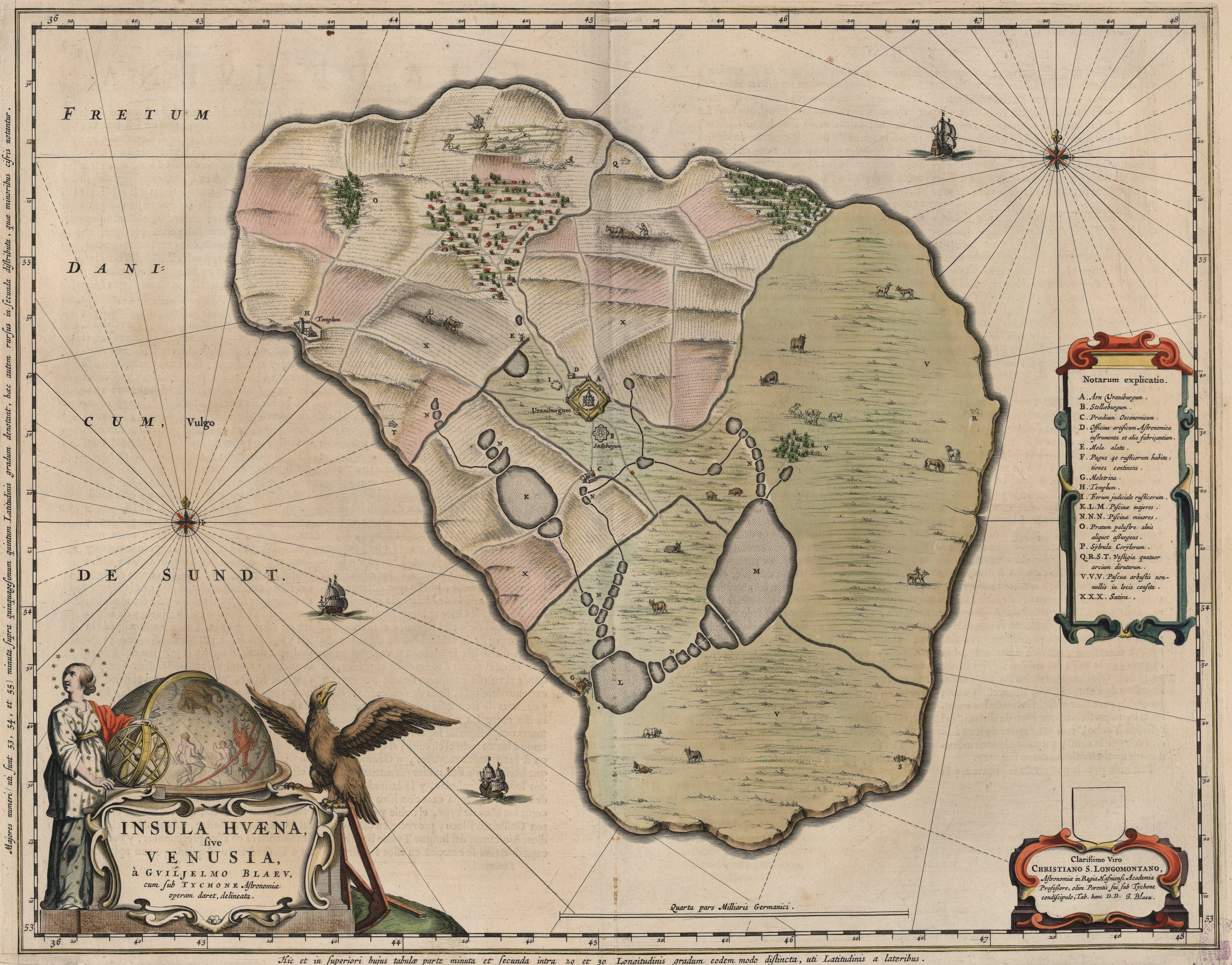
English: Map of the island of Hven from a copper etching of Willem Janszoon Blaeu's Blaeu Atlas 1663.
Willem made this map based on his experience as a student of Tycho Brahe between 1594 and 1596. On this map North is up, Denmark to the west and Scania, now part of Sweden, to the east. It shows the location of Uraniborg just above the centre, and below the linked set of ponds that Tycho had created to both collect water and power his papermill and other small industries on the island. Name of map : INSULAE HVAENA Map record source: Biblioteca Nacionale Espana (click on "View Digital object" to browse from the first page down to "GMG/189/177/mapa") (1664 is date of atlas on title page at "GMG/189/5/hg-ilustracionr") vorige upload: Tychobrahe.com
|
||||||||||||||||||||||||||
| Datum | |||||||||||||||||||||||||||
| Bron | (There is no permanent link) Browse to [1], click "View Digital Object", scroll down and click on link "GMG/189/177/mapa", image should appear named "GMG189177mapa.jpeg" in right hand panel. | ||||||||||||||||||||||||||
| Auteur |
|
||||||||||||||||||||||||||
.jpg)
|
Dit werk bevindt zich in het publiek domein in landen en gebieden waar de auteursrechttermijn het leven van de auteur plus 100 jaar of minder is. | |
| Van dit bestand is vastgesteld dat er geen bekende auteursrechtaanspraken op rusten, alle aanverwante en naburige rechten daarbij inbegrepen. | |
| Aantekeningen | Deze afbeelding is aangetekend: Bekijk de aantekeningen op Commons |


Bestandsgeschiedenis
Klik op een datum/tijd om het bestand te zien zoals het destijds was.
| Datum/tijd | Miniatuur | Afmetingen | Gebruiker | Opmerking | |
|---|---|---|---|---|---|
| huidige versie | 9 aug 2016 03:06 | | 6.304 × 4.939 (19,49 MB) | Centpacrr | crp |
| 4 jan 2013 13:46 |  | 7.598 × 6.341 (5,28 MB) | Joop Rotte | ietwat hogere resolutie | |
| 30 dec 2005 20:18 |  | 750 × 601 (89 kB) | Fred J | :: '' Originally uploaded on English Wikipedia by en:User:Wikibob. Map of the island of Hven from a copper etching of Willem Janszoon Blaeu's Blaeu Atlas 1663. Willem made this map while a student of Tycho Brahe between 1594 and 1596. On th |
Bestandsgebruik
Dit bestand wordt op de volgende pagina gebruikt:
Globaal bestandsgebruik
De volgende andere wiki's gebruiken dit bestand:
- Gebruikt op de.wikipedia.org
- Gebruikt op en.wikipedia.org
- Gebruikt op et.wikipedia.org
- Gebruikt op fa.wikipedia.org
- Gebruikt op fr.wikipedia.org
- Gebruikt op ia.wikipedia.org
- Gebruikt op ja.wikipedia.org
- Gebruikt op ko.wikipedia.org
- Gebruikt op la.wikipedia.org
- Gebruikt op mk.wikipedia.org
- Gebruikt op pl.wikipedia.org
- Gebruikt op ru.wikipedia.org
- Gebruikt op sv.wikipedia.org
- Gebruikt op uk.wikipedia.org
- Gebruikt op zh.wikipedia.org