
Bestand:Map of North Carolina highlighting Montgomery County.svg

Afmetingen van deze voorvertoning van het type PNG van dit SVG-bestand: 800 × 303 pixels Andere resoluties: 320 × 121 pixels | 640 × 243 pixels | 1.024 × 388 pixels | 1.280 × 485 pixels | 2.560 × 971 pixels | 8.061 × 3.056 pixels.
Oorspronkelijk bestand (SVG-bestand, nominaal 8.061 × 3.056 pixels, bestandsgrootte: 236 kB)
| Dit is een bestand van Wikimedia Commons. Onderstaande beschrijving komt van de beschrijving van het bestand daar. |
Beschrijving
| Beschrijving |
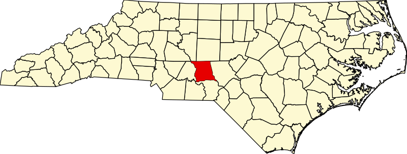
English: Locator map of Montgomery County — in central North Carolina.
|
| Datum | |
| Bron |
Eigen werk: English: The maps use data from nationalatlas.gov, specifically countyp020.tar.gz on the Raw Data Download page. The maps also use state outline data from statesp020.tar.gz. The Florida maps use hydrogm020.tar.gz to display Lake Okeechobee. |
| Auteur | David Benbennick |
Licentie
| Ik, de auteursrechthebbende van dit werk, geef dit werk vrij in het publieke domein. Dit is wereldwijd van toepassing. In sommige landen is dit wettelijk niet mogelijk; in die gevallen geldt: Ik sta iedereen toe dit werk voor eender welk doel te gebruiken, zonder enige voorwaarden, tenzij zulke voorwaarden door de wet worden voorgeschreven. |
en:Category:Montgomery County, North Carolina
Bestandsgeschiedenis
Klik op een datum/tijd om het bestand te zien zoals het destijds was.
| Datum/tijd | Miniatuur | Afmetingen | Gebruiker | Opmerking | |
|---|---|---|---|---|---|
| huidige versie | 12 feb 2006 17:49 | 8.061 × 3.056 (236 kB) | David Benbennick | {{subst:User:Dbenbenn/clm|county=Montgomery County|state=North Carolina|type=county}} |
Bestandsgebruik
Dit bestand wordt op de volgende pagina gebruikt:
Globaal bestandsgebruik
De volgende andere wiki's gebruiken dit bestand:
- Gebruikt op af.wikipedia.org
- Gebruikt op ar.wikipedia.org
- Gebruikt op bg.wikipedia.org
- Gebruikt op bpy.wikipedia.org
- Gebruikt op cdo.wikipedia.org
- Gebruikt op ceb.wikipedia.org
- Gebruikt op ce.wikipedia.org
- Gebruikt op cy.wikipedia.org
- Gebruikt op de.wikipedia.org
- Gebruikt op en.wikipedia.org
- Montgomery County, North Carolina
- List of counties in North Carolina
- Alasmidonta robusta
- Category:Wikipedia requested photographs in Montgomery County, North Carolina
- Biscoe Township, Montgomery County, North Carolina
- Cheek Creek Township, Montgomery County, North Carolina
- Eldorado Township, Montgomery County, North Carolina
- Gebruikt op eo.wikipedia.org
- Gebruikt op es.wikipedia.org
- Gebruikt op eu.wikipedia.org
- Gebruikt op fa.wikipedia.org
- Gebruikt op ga.wikipedia.org
- Gebruikt op ha.wikipedia.org
- Gebruikt op hu.wikipedia.org
- Gebruikt op it.wikipedia.org
- Gebruikt op ja.wikipedia.org
- Gebruikt op ko.wikipedia.org
- Gebruikt op nds.wikipedia.org
- Gebruikt op pl.wikipedia.org
- Gebruikt op pnb.wikipedia.org
- Gebruikt op pt.wikipedia.org
- Gebruikt op ro.wikipedia.org
- Gebruikt op ru.wikipedia.org
- Gebruikt op sh.wikipedia.org
- Gebruikt op simple.wikipedia.org
- Gebruikt op sr.wikipedia.org
- Gebruikt op sv.wikipedia.org
- Gebruikt op tr.wikipedia.org
Globaal gebruik van dit bestand bekijken.