
Bestand:Map of Ohio NA.png

Grootte van deze voorvertoning: 800 × 542 pixels. Andere resoluties: 320 × 217 pixels | 640 × 434 pixels | 1.024 × 694 pixels | 1.280 × 867 pixels | 1.967 × 1.333 pixels.
Oorspronkelijk bestand (1.967 × 1.333 pixels, bestandsgrootte: 2,02 MB, MIME-type: image/png)
| Dit is een bestand van Wikimedia Commons. Onderstaande beschrijving komt van de beschrijving van het bestand daar. |
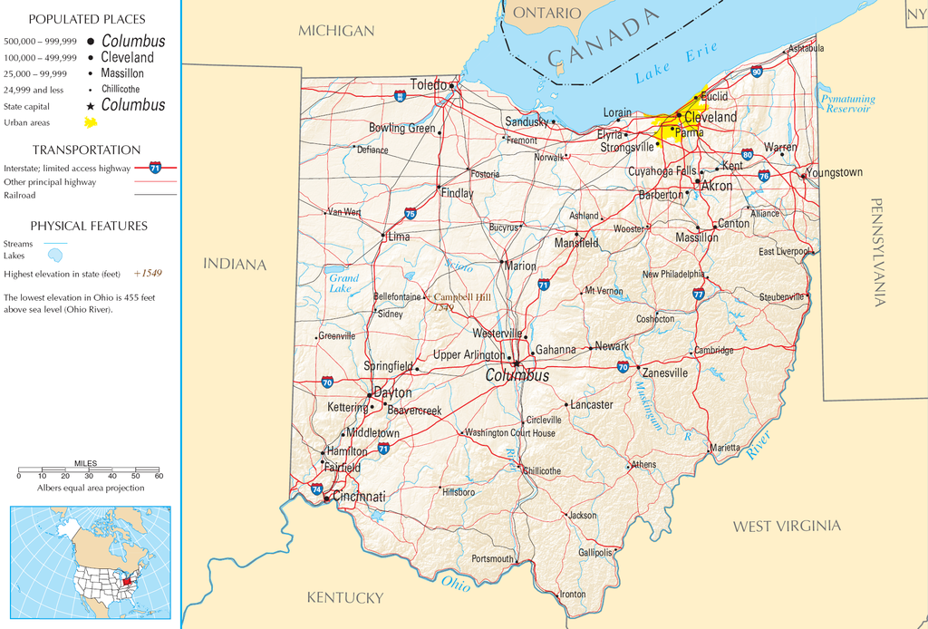
| Beschrijving | Map of Ohio |
| Bron | National Atlas |
| Auteur |
This map was obtained from an edition of the National Atlas of the United States. Like almost all works of the U.S. federal government, works from the National Atlas are in the public domain in the United States.
Online access: NationalAtlas.gov | 1970 print edition: Library of Congress, Perry-Castañeda Library
|
Bestandsgeschiedenis
Klik op een datum/tijd om het bestand te zien zoals het destijds was.
| Datum/tijd | Miniatuur | Afmetingen | Gebruiker | Opmerking | |
|---|---|---|---|---|---|
| huidige versie | 30 aug 2007 13:21 | | 1.967 × 1.333 (2,02 MB) | Conscious | cropped |
| 15 aug 2006 10:02 |  | 2.122 × 1.640 (2,17 MB) | Huebi~commonswiki | {{Information| |Description=Map of Ohio |Source=[http://www.nationalatlas.gov National Atlas] }} Category:Maps of the United States Category:Maps of Ohio {{PD-USGov-Atlas}} |
Bestandsgebruik
Dit bestand wordt op de volgende pagina gebruikt:
Globaal bestandsgebruik
De volgende andere wiki's gebruiken dit bestand:
- Gebruikt op arz.wikipedia.org
- Gebruikt op de.wikipedia.org
- Gebruikt op en.wikipedia.org
- Gebruikt op es.wikipedia.org
- Gebruikt op eu.wikipedia.org
- Gebruikt op fr.wikipedia.org
- Gebruikt op gl.wikipedia.org
- Gebruikt op hr.wiktionary.org
- Gebruikt op hsb.wikipedia.org
- Gebruikt op hu.wikipedia.org
- Gebruikt op incubator.wikimedia.org
- Gebruikt op io.wikipedia.org
- Gebruikt op it.wikipedia.org
- Gebruikt op ja.wikipedia.org
- Gebruikt op kk.wikipedia.org
- Gebruikt op mk.wikipedia.org
- Gebruikt op mr.wikipedia.org
- Gebruikt op rue.wikipedia.org
- Gebruikt op ru.wikipedia.org
- Gebruikt op stq.wikipedia.org
- Gebruikt op sw.wikipedia.org
- Gebruikt op szl.wikipedia.org
- Gebruikt op zea.wikipedia.org