
Bestand:Map of Florida by John de Solís (1764).jpg

Grootte van deze voorvertoning: 460 × 599 pixels. Andere resoluties: 184 × 240 pixels | 368 × 480 pixels | 589 × 768 pixels | 786 × 1.024 pixels | 2.075 × 2.704 pixels.
Oorspronkelijk bestand (2.075 × 2.704 pixels, bestandsgrootte: 634 kB, MIME-type: image/jpeg)
| Dit is een bestand van Wikimedia Commons. Onderstaande beschrijving komt van de beschrijving van het bestand daar. |
.jpg)
Beschrijving
| Beschrijving |
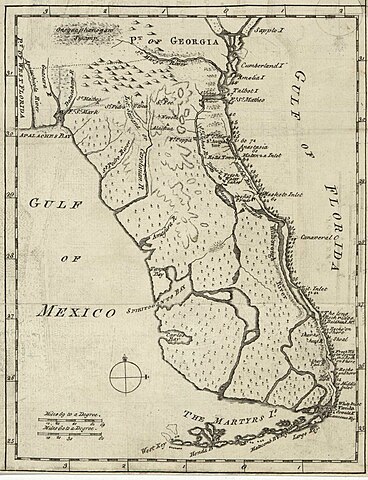
English: Map of Florida of ca. 1764]].
|
| Datum | ca. 1764 |
| Bron | US Library of Congress |
| Auteur | "Don John de Solís, surveyor, who resided there near twenty years" |
Licentie
|
Dit werk bevindt zich in het publiek domein in landen en gebieden waar de auteursrechttermijn het leven van de auteur plus 100 jaar of minder is. | |
| Van dit bestand is vastgesteld dat er geen bekende auteursrechtaanspraken op rusten, alle aanverwante en naburige rechten daarbij inbegrepen. | |
Bestandsgeschiedenis
Klik op een datum/tijd om het bestand te zien zoals het destijds was.
| Datum/tijd | Miniatuur | Afmetingen | Gebruiker | Opmerking | |
|---|---|---|---|---|---|
| huidige versie | 28 mei 2018 01:06 | | 2.075 × 2.704 (634 kB) | Hispalois | Higher-resolution image. Please note that this map has no relationship whatsoever with 16th-century explorer Juan Díaz de Solís. |
| 15 jun 2006 19:16 |  | 399 × 500 (49 kB) | Eamezaga | Map published in the US depicting a very accurate shape of Florida (1764), based on an ancient draft drawn by the Spanish-Portuguese explorer and discoverer Juan Díaz de Solís (US Library of Congress, released to public domain) |
Bestandsgebruik
Geen enkele pagina gebruikt dit bestand.
Globaal bestandsgebruik
De volgende andere wiki's gebruiken dit bestand:
- Gebruikt op en.wikipedia.org
- Gebruikt op it.wikipedia.org
.jpg)