
Bestand:MountAkutan.jpg

Grootte van deze voorvertoning: 800 × 538 pixels. Andere resoluties: 320 × 215 pixels | 640 × 430 pixels | 1.024 × 688 pixels.
Oorspronkelijk bestand (1.024 × 688 pixels, bestandsgrootte: 247 kB, MIME-type: image/jpeg)
| Dit is een bestand van Wikimedia Commons. Onderstaande beschrijving komt van de beschrijving van het bestand daar. |
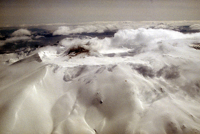
Aerial view of Akutan volcano that forms the west part of Akutan Island in the eastern Aleutian Islands. The volcano's summit is truncated by a 2-km-wide (1.2 mi) caldera that contains a cinder cone that has been the site of frequent historical eruptions. View is to the southeast.
Photograph by C. Nye, Alaska Division of Geological and Geophysical Surveys, May 10, 1994. Source: http://geopubs.wr.usgs.gov/dds/dds-40/
Deze afbeelding bevindt zich in het publiek domein omdat het materiaal bevat dat oorspronkelijk afkomstig is van de United States Geological Survey, een agentschap van de United States Department of the Interior. Voor meer informatie, zie het officiële USGS-auteursrechtenbeleid
|
Bestandsgeschiedenis
Klik op een datum/tijd om het bestand te zien zoals het destijds was.
| Datum/tijd | Miniatuur | Afmetingen | Gebruiker | Opmerking | |
|---|---|---|---|---|---|
| huidige versie | 28 jan 2005 14:55 | | 1.024 × 688 (247 kB) | GarciaB~commonswiki | Mount Akutan, Alaska |
Bestandsgebruik
Dit bestand wordt op de volgende pagina gebruikt:
Globaal bestandsgebruik
De volgende andere wiki's gebruiken dit bestand:
- Gebruikt op ca.wikipedia.org
- Gebruikt op ceb.wikipedia.org
- Gebruikt op cs.wikipedia.org
- Gebruikt op de.wikipedia.org
- Gebruikt op en.wikipedia.org
- Gebruikt op es.wikipedia.org
- Gebruikt op eu.wikipedia.org
- Gebruikt op fi.wikipedia.org
- Gebruikt op ga.wikipedia.org
- Gebruikt op gv.wikipedia.org
- Gebruikt op hy.wikipedia.org
- Gebruikt op it.wikipedia.org
- Gebruikt op ms.wikipedia.org
- Gebruikt op no.wikipedia.org
- Gebruikt op uk.wikipedia.org
- Gebruikt op ur.wikipedia.org
- Gebruikt op www.wikidata.org
- Gebruikt op zh.wikipedia.org