
Bestand:National-atlas-pennsylvania.png
Geen hogere resolutie beschikbaar.
National-atlas-pennsylvania.png (762 × 590 pixels, bestandsgrootte: 140 kB, MIME-type: image/png)
| Dit is een bestand van Wikimedia Commons. Onderstaande beschrijving komt van de beschrijving van het bestand daar. |
Beschrijving
| Beschrijving |
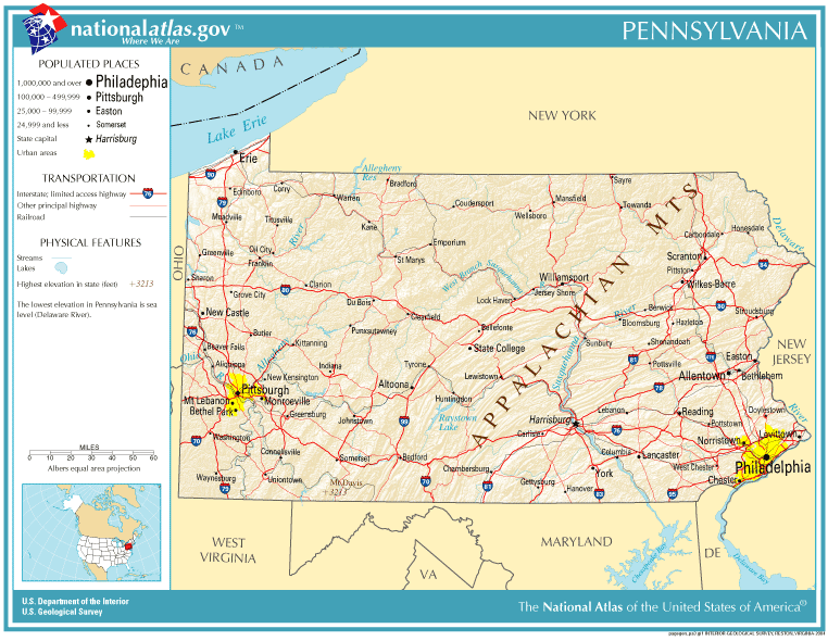
English: Map of Pennsylvania. |
| Datum | |
| Bron | National Atlas |
| Auteur |
Licentie
This map was obtained from an edition of the National Atlas of the United States. Like almost all works of the U.S. federal government, works from the National Atlas are in the public domain in the United States.
Online access: NationalAtlas.gov | 1970 print edition: Library of Congress, Perry-Castañeda Library
|
Bestandsgeschiedenis
Klik op een datum/tijd om het bestand te zien zoals het destijds was.
| Datum/tijd | Miniatuur | Afmetingen | Gebruiker | Opmerking | |
|---|---|---|---|---|---|
| huidige versie | 14 okt 2005 21:10 | | 762 × 590 (140 kB) | Warden | Reverted to earlier revision |
| 11 sep 2005 20:19 |  | 762 × 590 (140 kB) | Shauni | {{PD-USGov-Atlas}} Category:Maps of Pennsylvania |
Bestandsgebruik
Dit bestand wordt op de volgende pagina gebruikt:
Globaal bestandsgebruik
De volgende andere wiki's gebruiken dit bestand:
- Gebruikt op ast.wikipedia.org
- Gebruikt op bn.wikipedia.org
- Gebruikt op ca.wikipedia.org
- Gebruikt op da.wikipedia.org
- Gebruikt op en.wikipedia.org
- Gebruikt op es.wikipedia.org
- Gebruikt op io.wikipedia.org
- Gebruikt op ja.wikipedia.org
- Gebruikt op mk.wikipedia.org
- Gebruikt op mr.wikipedia.org
- Gebruikt op new.wikipedia.org
- Gebruikt op ru.wikipedia.org