
Bestand:Non-Native-American-Nations-Territorial-Claims-over-NAFTA-countries-1750-2008.gif
Grootte van deze voorvertoning: 536 × 600 pixels. Andere resoluties: 214 × 240 pixels | 429 × 480 pixels | 670 × 750 pixels.
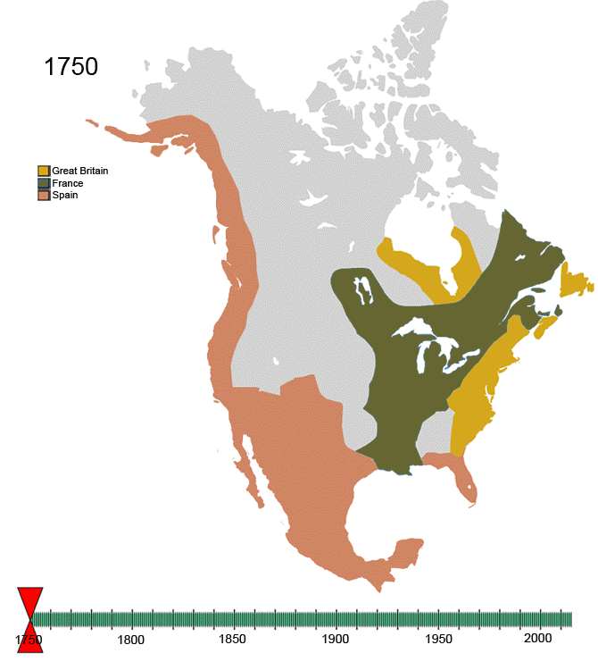
Oorspronkelijk bestand (670 × 750 pixels, bestandsgrootte: 741 kB, MIME-type: image/gif, herhalend, 97 frames, 1 min 56 s)
| Dit is een bestand van Wikimedia Commons. Onderstaande beschrijving komt van de beschrijving van het bestand daar. |
For notes on the individual border changes see Territorial evolution of North America. To make your own animated image use the slides below:
| France | |||
| Present day Canada | |||
|---|---|---|---|
| Canada | |||
| Dominion of Newfoundland | |||
| France | |||
| Britain | |||
| Present day USA | |||
| United States of America | |||
| California Republic | |||
| Confederate States of America | |||
| France | |||
| Republic of Indian Stream | No flag | ||
| Republic of Texas | |||
| Republic of Vermont | |||
| Republic of West Florida | |||
| Russia | |||
| Spain | |||
| Britain | |||
| Present day Mexico | |||
| Federal Republic of Central America | |||
| Mexico | |||
| Spain | |||
| Republic of the Rio Grande | |||
| Yucatán | |||
Images


See Also
-
 |North America
 -
 |Central America
 -
 |Balkans
 -
 |South America
 -

-

-


Beschrijving
| Beschrijving | Non-Native-American Nation's Control over North America circa 1750-2008 | ||
| Datum | Created March, 2008 | ||
| Bron | Eigen werk | ||
| Auteur | Esemono | ||
| Toestemming (Hergebruik van dit bestand) |
|
Bestandsgeschiedenis
Klik op een datum/tijd om het bestand te zien zoals het destijds was.
| Datum/tijd | Miniatuur | Afmetingen | Gebruiker | Opmerking | |
|---|---|---|---|---|---|
| huidige versie | 21 jan 2010 16:32 | | 670 × 750 (741 kB) | Esemono | See talk page |
| 19 jan 2010 18:14 |  | 700 × 783 (537 kB) | Maps & Lucy | Correct version by same uploader which also exists as a different file. The Spanish explored but did not CLAIM the Pacific coast all the way up to the Russians. Do not revert! | |
| 17 jan 2010 15:28 |  | 670 × 750 (741 kB) | Esemono | Fix mexico | |
| 12 jan 2010 14:05 |  | 670 × 750 (731 kB) | Esemono | Reverted to version as of 23:46, 3 January 2010 | |
| 12 jan 2010 03:23 |  | 670 × 750 (651 kB) | Maps & Lucy | Fixing map to make thumbnail version display | |
| 11 jan 2010 17:49 |  | 670 × 750 (651 kB) | Maps & Lucy | Reverted back to accurate image. The Spanish did not CONTROL the north Pacific strip, they just explored it and that does not count | |
| 4 jan 2010 01:46 |  | 670 × 750 (731 kB) | Esemono | Change Spanish control on the Pacific | |
| 1 jan 2010 09:45 |  | 670 × 750 (651 kB) | Esemono | Fix NWT island and UK Great Britian | |
| 1 jan 2010 03:32 |  | 670 × 750 (651 kB) | Esemono | Add pig war, and Rio Rico | |
| 3 dec 2009 15:15 |  | 670 × 750 (546 kB) | Esemono | timeline |
Bestandsgebruik
Dit bestand wordt op de volgende pagina gebruikt:
Globaal bestandsgebruik
De volgende andere wiki's gebruiken dit bestand:
- Gebruikt op af.wikipedia.org
- Gebruikt op anp.wikipedia.org
- Gebruikt op ast.wikipedia.org
- Gebruikt op azb.wikipedia.org
- Gebruikt op az.wikipedia.org
- Gebruikt op be.wikipedia.org
- Gebruikt op bg.wikipedia.org
- Gebruikt op ca.wikipedia.org
- Gebruikt op ce.wikipedia.org
- Gebruikt op cs.wikipedia.org
- Gebruikt op da.wikipedia.org
- Gebruikt op de.wikipedia.org
- Gebruikt op el.wikipedia.org
- Gebruikt op en.wikipedia.org
- History of the Americas
- First Nations in Canada
- List of conflicts in North America
- Talk:History of the Northwest Territories
- List of land borders with dates of establishment
- User:Esemono/NorthAmerica
- Territorial evolution of North America since 1763
- User:Kazkaskazkasako/Books/History
- Wikipedia:Village pump (technical)/Archive 110
- List of conflicts in Mexico
- User:SomeGuyWhoRandomlyEdits/List of conflicts in Mexico
- Gebruikt op en.wikiquote.org
- Gebruikt op es.wikipedia.org
- Gebruikt op fa.wikipedia.org
- Gebruikt op fiu-vro.wikipedia.org
- Gebruikt op fr.wikipedia.org
- Gebruikt op gan.wikipedia.org
- Gebruikt op gl.wikipedia.org
- Gebruikt op hi.wikipedia.org
- Gebruikt op hr.wikipedia.org
- Gebruikt op hu.wikipedia.org
- Gebruikt op hy.wikipedia.org
- Gebruikt op id.wikipedia.org
- Gebruikt op ja.wikipedia.org
- Gebruikt op ka.wikipedia.org
Globaal gebruik van dit bestand bekijken.