
Bestand:Outer Space Treaty-SVG.svg

Oorspronkelijk bestand (SVG-bestand, nominaal 863 × 443 pixels, bestandsgrootte: 1,61 MB)
| Dit is een bestand van Wikimedia Commons. Onderstaande beschrijving komt van de beschrijving van het bestand daar. |
Beschrijving
| Beschrijving |
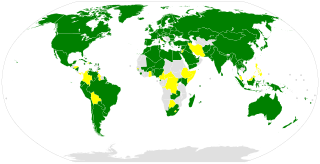
English: Map of the members of the Outer Space Treaty as of 1 January 2020.
Signed and Ratified
Signed only
Not signed Nederlands: Kaart met de leden van het Ruimteverdrag op 1 januari 2020.
Ondertekend en geratificeerd
Alleen ondertekend
Niet ondertekend Deutsch: Karte mit den Vertragsstaaten des Weltraumvertrags, 1. Januar 2020.
Unterzeichnet und ratifiziert
Nur unterzeichnet
Nicht unterzeichnet |
| Datum | |
| Bron |
|
| Auteur | |
| Andere versies |
|


Licentie
| This image is a map derived from a United Nations map.
Unless stated otherwise, UN maps are to be considered in the public domain. This applies worldwide. UN maps are, in principle, open source material and you can use them in your work or for making your own map. UN requests however that you delete the UN name, logo and reference number upon any modification to the map. Content of your map will be your responsibility. You can state in your publication, if you wish, something like: based on UN map … (map name, map number, revision number and date). See: Geospatial Information Section. And: Geospatial, location data for a better world. |
 |
Bestandsgeschiedenis
Klik op een datum/tijd om het bestand te zien zoals het destijds was.
| Datum/tijd | Miniatuur | Afmetingen | Gebruiker | Opmerking | |
|---|---|---|---|---|---|
| huidige versie | 16 mei 2020 15:16 | | 863 × 443 (1,61 MB) | Hanzlan | +am,lt,si... |
| 29 dec 2013 22:45 |  | 863 × 443 (1,61 MB) | WillemBK | User created page with UploadWizard |
Bestandsgebruik
Dit bestand wordt op de volgende pagina gebruikt:
Globaal bestandsgebruik
De volgende andere wiki's gebruiken dit bestand:
- Gebruikt op af.wikipedia.org
- Gebruikt op be.wikipedia.org
- Gebruikt op de.wikipedia.org
- Gebruikt op en.wikipedia.org
- Gebruikt op es.wikipedia.org
- Gebruikt op fr.wikipedia.org
- Gebruikt op it.wikipedia.org
- Gebruikt op ru.wikipedia.org
- Gebruikt op uk.wikipedia.org
- Gebruikt op zh.wikipedia.org