
Bestand:River Nith estuary.jpg

Grootte van deze voorvertoning: 800 × 533 pixels. Andere resoluties: 320 × 213 pixels | 640 × 427 pixels | 1.024 × 683 pixels | 1.280 × 853 pixels | 2.560 × 1.707 pixels | 3.504 × 2.336 pixels.
Oorspronkelijk bestand (3.504 × 2.336 pixels, bestandsgrootte: 8,68 MB, MIME-type: image/jpeg)
| Dit is een bestand van Wikimedia Commons. Onderstaande beschrijving komt van de beschrijving van het bestand daar. |
Beschrijving
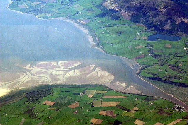
| Beschrijving | The estuary of the River Nith, Scotland, at low tide; opening into Solway Firth. This is a view of the Nith estuary from the north-east. The group of buildings at bottom right is the village of Glencaple. At bottom left near the wooded area is Caerlaverock Castle. At top right is Loch Kindar and the hill above is called Criffel. Just beyond the top left of photo is the birthplace of John Paul Jones. |
| Datum | |
| Bron | https://www.flickr.com/photos/52614599@N00/483602946 |
| Auteur | Doc Searls from Santa Barbara, USA |
Licentie
Dit bestand is gelicenseerd onder de Creative Commons-licentie Naamsvermelding-Gelijk delen 2.0 Unported
- De gebruiker mag:
- Delen – het werk kopiëren, verspreiden en doorgeven
- Remixen – afgeleide werken maken
- Onder de volgende voorwaarden:
- naamsvermelding – U moet op een gepaste manier aan naamsvermelding doen, een link naar de licentie geven, en aangeven of er wijzigingen in het werk zijn aangebracht. U mag dit op elke redelijke manier doen, maar niet zodanig dat de indruk wordt gewekt dat de licentiegever instemt met uw werk of uw gebruik van zijn werk.
- Gelijk delen – Als u het werk heeft geremixt, veranderd, of erop heeft voortgebouwd, moet u het gewijzigde materiaal verspreiden onder dezelfde licentie als het oorspronkelijke werk, of een daarmee compatibele licentie.
| Deze afbeelding is oorspronkelijk op Flickr geplaatst door dsearls op https://www.flickr.com/photos/52614599@N00/483602946. Dit is op 5 mei 2007 door de FlickreviewR-Bot beoordeeld en de licentie onder de voorwaarden van cc-by-sa-2.0 is bevestigd. |
This is a view of the Nith estuary from the north-east. The group of buildings at bottom right is the village of Glencaple. At bottom left near the wooded area is Caerlaverock Castle. At top right is Loch Kindar and the hill above is called Criffel. Just beyond the top left of photo is the birthplace of John Paul Jones.
Bestandsgeschiedenis
Klik op een datum/tijd om het bestand te zien zoals het destijds was.
| Datum/tijd | Miniatuur | Afmetingen | Gebruiker | Opmerking | |
|---|---|---|---|---|---|
| huidige versie | 5 mei 2007 09:14 | | 3.504 × 2.336 (8,68 MB) | Sandstein | {{Information |Description= The estuary of the River Nith, Scotland, at low tide; opening into Solway Firth. On the near shore, Bowness-on-Solway. On the far, Annan, in Dumfries and Galloway. |Source= http://www.flickr.com/photos/52614599@N00/483602946 |D |
Bestandsgebruik
Dit bestand wordt op de volgende 2 pagina's gebruikt:
Globaal bestandsgebruik
De volgende andere wiki's gebruiken dit bestand:
- Gebruikt op ar.wikipedia.org
- Gebruikt op arz.wikipedia.org
- Gebruikt op ast.wikipedia.org
- Gebruikt op bn.wikipedia.org
- Gebruikt op br.wikipedia.org
- Gebruikt op ceb.wikipedia.org
- Gebruikt op cs.wikipedia.org
- Gebruikt op cy.wikipedia.org
- Gebruikt op dag.wikipedia.org
- Gebruikt op de.wikipedia.org
- Gebruikt op en.wikipedia.org
- Gebruikt op en.wikivoyage.org
- Gebruikt op eo.wikipedia.org
- Gebruikt op es.wikipedia.org
- Gebruikt op eu.wikipedia.org
- Gebruikt op fa.wikipedia.org
- Gebruikt op fr.wikipedia.org
- Gebruikt op fy.wikipedia.org
- Gebruikt op ga.wikipedia.org
- Gebruikt op gd.wikipedia.org
- Gebruikt op gv.wikipedia.org
- Gebruikt op hak.wikipedia.org
- Gebruikt op id.wikipedia.org
- Gebruikt op incubator.wikimedia.org
- Gebruikt op it.wikipedia.org
- Gebruikt op it.wikibooks.org
- Gebruikt op it.wikiversity.org
- Gebruikt op ja.wikipedia.org
- Gebruikt op kbd.wikipedia.org
- Gebruikt op lt.wikipedia.org
- Gebruikt op nn.wikipedia.org
Globaal gebruik van dit bestand bekijken.