
Bestand:SomersetTauntonDeane.png
Geen hogere resolutie beschikbaar.
SomersetTauntonDeane.png (200 × 101 pixels, bestandsgrootte: 10 kB, MIME-type: image/png)
| Dit is een bestand van Wikimedia Commons. Onderstaande beschrijving komt van de beschrijving van het bestand daar. |
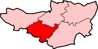
Taunton and Deane in Somerset
Created by en:User:Morwen

|
Toestemming wordt verleend voor het kopiëren, verspreiden en/of wijzigen van dit document onder de voorwaarden van de GNU-licentie voor vrije documentatie, versie 1.2 of enige latere versie als gepubliceerd door de Free Software Foundation; zonder Invariant Sections, zonder Front-Cover Texts, en zonder Back-Cover Texts. Een kopie van de licentie is opgenomen in de sectie GNU-licentie voor vrije documentatie. |
| Dit bestand is gelicenseerd onder de Creative Commons-licentie Naamsvermelding-Gelijk delen 3.0 Unported | ||
| ||
| Deze licentietag is toegevoegd aan dit bestand in verband met de GFDL licentie-update. |
Bestandsgeschiedenis
Klik op een datum/tijd om het bestand te zien zoals het destijds was.
| Datum/tijd | Miniatuur | Afmetingen | Gebruiker | Opmerking | |
|---|---|---|---|---|---|
| huidige versie | 24 mei 2006 17:11 | | 200 × 101 (10 kB) | Nichtbesserwisser | Taunton and Deane in Somerset Created by en:User:Morwen {{GFDL}} Category:Maps of districts in South West England |
Bestandsgebruik
Dit bestand wordt op de volgende pagina gebruikt:
Globaal bestandsgebruik
De volgende andere wiki's gebruiken dit bestand:
- Gebruikt op bg.wikipedia.org
- Gebruikt op de.wikipedia.org
- Gebruikt op en.wikipedia.org
- Taunton
- Wellington, Somerset
- Creech St Michael
- Combe Florey
- Milverton, Somerset
- Ash Priors
- Ashbrittle
- Bathealton
- Bickenhall
- Bishop's Hull
- Bishops Lydeard
- Bradford-on-Tone
- Burrowbridge
- Cheddon Fitzpaine
- Chipstable
- Churchstanton
- Comeytrowe
- Corfe
- Cothelstone
- Curland
- Durston
- Fitzhead
- Halse, Somerset
- Hatch Beauchamp
- Kingston St Mary
- Langford Budville
- Lydeard St Lawrence
- North Curry
- Norton Fitzwarren
- Nynehead
- Oake
- Orchard Portman
- Otterford
- Pitminster
- Ruishton
- Sampford Arundel
- Staple Fitzpaine
- Stawley
- Stoke St Gregory
- Stoke St Mary
- Thornfalcon
- Tolland, Somerset
- Trull
- West Bagborough
- West Buckland
- West Hatch
- West Monkton
Globaal gebruik van dit bestand bekijken.