
Bestand:Trans Alaska Pipeline Denali fault shift.jpg
Grootte van deze voorvertoning: 800 × 600 pixels. Andere resoluties: 320 × 240 pixels | 640 × 480 pixels | 1.024 × 768 pixels | 1.280 × 960 pixels | 2.560 × 1.920 pixels.
Oorspronkelijk bestand (2.560 × 1.920 pixels, bestandsgrootte: 570 kB, MIME-type: image/jpeg)
| Dit is een bestand van Wikimedia Commons. Onderstaande beschrijving komt van de beschrijving van het bestand daar. |
Beschrijving
| Beschrijving |
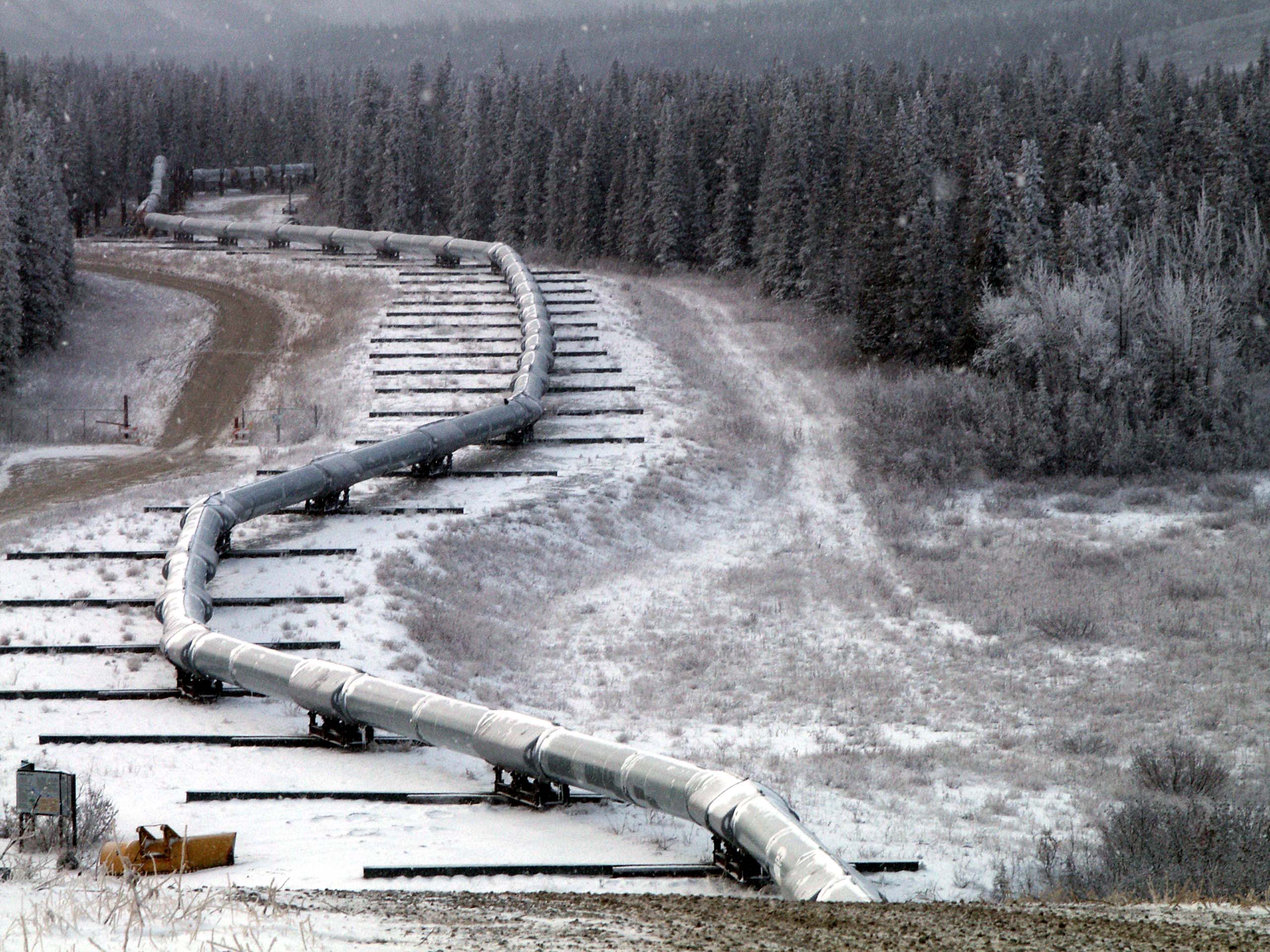
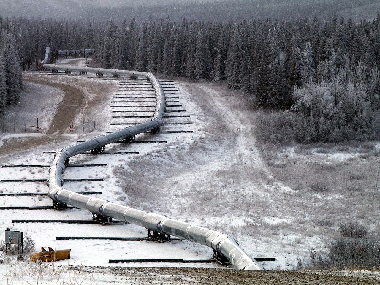
English: Trace of the Denali Fault after the 7.9 magnitude earthquake of 3 November 2002, Alaska, USA. View south along the Trans-Alaska Pipeline System in the zone where it was engineered to cross the fault (the pipeline rests on sliders rather than rigid pillar supports). The fault trace passes beneath the pipeline between the 2nd and 3rd slider supports at the far end of the zone. A large arc in the pipe can be seen in the pipe on the right, due to shortening of the zigzag-shaped pipeline trace within the fault zone. It was snowing when the photo was taken. |
| Datum | |
| Bron | Denali Fault Earthquake Photos 07 Nov 2002 (Direct link) |
| Auteur | U.S. Geological Survey employee |
| Cameralocatie | | Deze en andere afbeeldingen in: OpenStreetMap |
|---|
Licentie
Deze afbeelding bevindt zich in het publiek domein omdat het materiaal bevat dat oorspronkelijk afkomstig is van de United States Geological Survey, een agentschap van de United States Department of the Interior. Voor meer informatie, zie het officiële USGS-auteursrechtenbeleid
|
Bestandsgeschiedenis
Klik op een datum/tijd om het bestand te zien zoals het destijds was.
| Datum/tijd | Miniatuur | Afmetingen | Gebruiker | Opmerking | |
|---|---|---|---|---|---|
| huidige versie | 4 aug 2007 07:58 | | 2.560 × 1.920 (570 kB) | Whhalbert | |
| 4 aug 2007 07:55 |  | 800 × 600 (137 kB) | Whhalbert | == Summary == Alaska Denali Fault after November 3rd 7.9 magnitude earthquake: November 7, 2002. View south along the Trans-Alaska Pipeline System in the zone where it was engineered for the Denali fault. The fault trace passes beneath th |
Bestandsgebruik
Dit bestand wordt op de volgende pagina gebruikt:
Globaal bestandsgebruik
De volgende andere wiki's gebruiken dit bestand:
- Gebruikt op de.wikipedia.org
- Gebruikt op en.wikipedia.org
- Gebruikt op en.wikibooks.org
- Gebruikt op es.wikipedia.org
- Gebruikt op fa.wikipedia.org
- Gebruikt op fi.wikipedia.org
- Gebruikt op fr.wikipedia.org
- Gebruikt op ja.wikipedia.org
- Gebruikt op pl.wikipedia.org
- Gebruikt op ru.wikipedia.org
- Gebruikt op th.wikipedia.org
- Gebruikt op tr.wikipedia.org
- Gebruikt op zh.wikipedia.org