
Bestand:Western Han Mawangdui Silk Map.JPG

Grootte van deze voorvertoning: 621 × 600 pixels. Andere resoluties: 249 × 240 pixels | 497 × 480 pixels | 795 × 768 pixels | 1.060 × 1.024 pixels | 2.121 × 2.048 pixels | 3.675 × 3.549 pixels.
Oorspronkelijk bestand (3.675 × 3.549 pixels, bestandsgrootte: 3,07 MB, MIME-type: image/jpeg)
| Dit is een bestand van Wikimedia Commons. Onderstaande beschrijving komt van de beschrijving van het bestand daar. |
Beschrijving
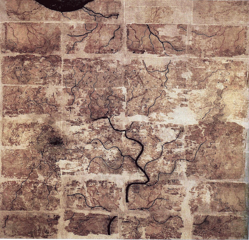
| Beschrijving | A Chinese topographic map (with the south positioned at the top) from Mawangdui tomb 3; dated to the early Western Han period (183–168 BC); length is 96 cm; width is 96 cm; the map is made of ink on silk. It is now housed in the Hunan Provincial Museum, Changsha. The map depicts a large territory in southern China spanning from the imperial fiefdom of Changsha (a semi-autonomous kingdom within the Han Empire, now modern-day Hunan) to the independent and sometimes hostile Kingdom of Nanyue in what is now modern-day Guangdong and northern Vietnam. |
| Datum | 2nd century BC (anywhere from 183 to 168 BC) |
| Bron | Scanned from Barbieri-Low, Anthony J. (2007). Artisans in Early Imperial China. Seattle and London: University of Washington Press. ISBN 0295987138. Page 174. |
| Auteur | Anonymous ancient Chinese cartographer |
| Andere versies | Afgeleide werken van dit bestand: Cypraea mappa map comparison.jpg |
Licentie
|
Het tweedimensionale kunstwerk afgebeeld op deze afbeelding valt in het publiek domein omdat:
Reproducties van het werk kunnen ook worden beschouwd als publiek domein omdat ze geen oorspronkelijk karakter hebben. Dit geldt voor reproducties gemaakt in de Verenigde Staten (zie Bridgeman Art Library v. Corel Corp.), Duitsland en veel andere landen.
| ||||
Bestandsgeschiedenis
Klik op een datum/tijd om het bestand te zien zoals het destijds was.
| Datum/tijd | Miniatuur | Afmetingen | Gebruiker | Opmerking | |
|---|---|---|---|---|---|
| huidige versie | 11 mei 2018 00:58 | | 3.675 × 3.549 (3,07 MB) | Soerfm | Brightness, color, crop. |
| 28 apr 2009 00:10 |  | 3.675 × 3.549 (2,89 MB) | PericlesofAthens | {{Information |Description=A Chinese topographic map (with the south positioned at the top) from Mawangdui tomb 3; dated to the early Western Han period (183–168 BC); length is 96 cm; width is 96 cm; the map is made of ink on silk. It is now housed |
Bestandsgebruik
Dit bestand wordt op de volgende pagina gebruikt:
Globaal bestandsgebruik
De volgende andere wiki's gebruiken dit bestand:
- Gebruikt op als.wikipedia.org
- Gebruikt op ca.wikipedia.org
- Gebruikt op de.wikipedia.org
- Gebruikt op en.wikipedia.org
- Gebruikt op es.wikipedia.org
- Gebruikt op fi.wikipedia.org
- Gebruikt op fr.wikipedia.org
- Gebruikt op hr.wikipedia.org
- Gebruikt op id.wikipedia.org
- Gebruikt op it.wikipedia.org
- Gebruikt op ja.wikipedia.org
- Gebruikt op km.wikipedia.org
- Gebruikt op ko.wikipedia.org
- Gebruikt op mwl.wikipedia.org
- Gebruikt op pl.wikipedia.org
- Gebruikt op pnb.wikipedia.org
- Gebruikt op pt.wikipedia.org
- Gebruikt op ro.wikipedia.org
- Gebruikt op ru.wikipedia.org
Globaal gebruik van dit bestand bekijken.