
Bestand:Wilderness May5 0700.png
Grootte van deze voorvertoning: 800 × 324 pixels. Andere resoluties: 320 × 130 pixels | 640 × 259 pixels | 1.024 × 415 pixels | 1.280 × 518 pixels | 2.719 × 1.101 pixels.
Oorspronkelijk bestand (2.719 × 1.101 pixels, bestandsgrootte: 636 kB, MIME-type: image/png)
| Dit is een bestand van Wikimedia Commons. Onderstaande beschrijving komt van de beschrijving van het bestand daar. |
| Beschrijving |
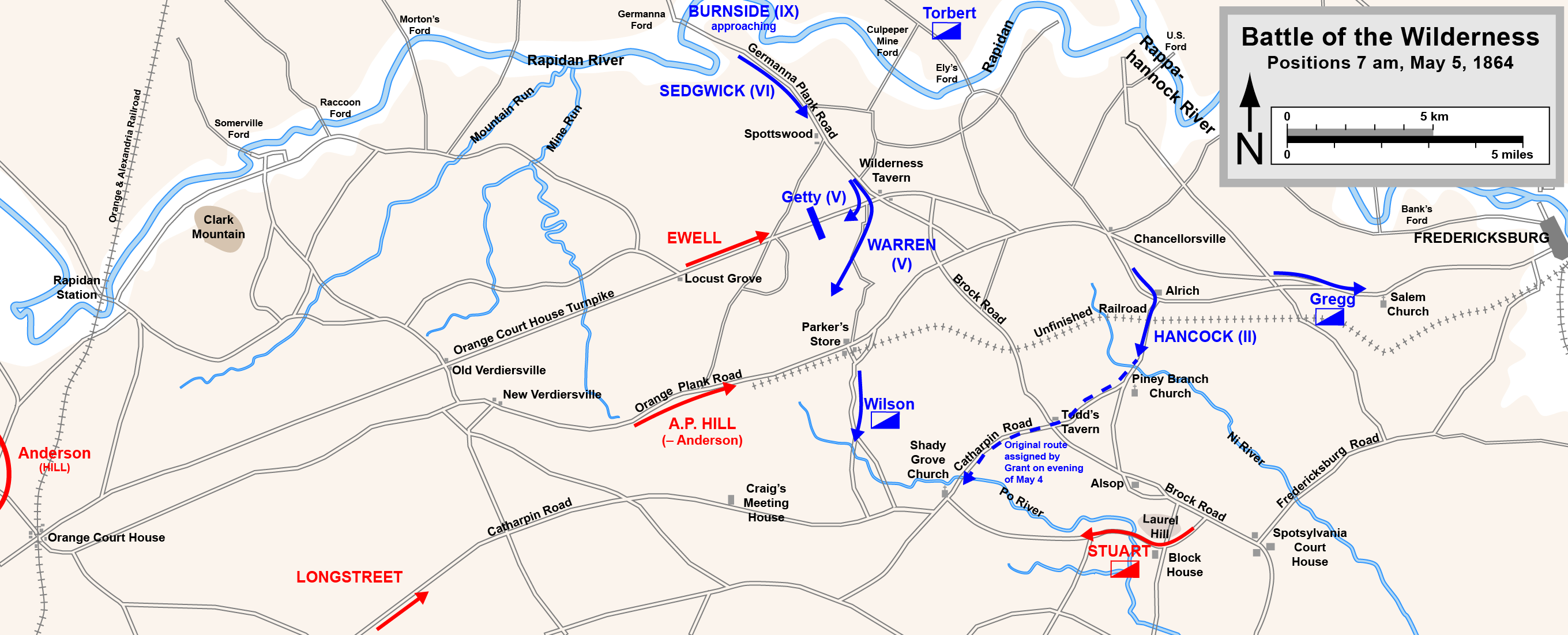
English: Map of the initial positions in the Battle of the Wilderness of the American Civil War.
Drawn in Adobe Illustrator CS5 by Hal Jespersen. Graphic source file is available at http://www.posix.com/CWmaps/ Dit bestand is gelicenseerd onder de Creative Commons-licentie Naamsvermelding 3.0 Unported Naamsvermelding: Map by Hal Jespersen, www.posix.com/CW
|
| Datum | |
| Bron | Eigen werk |
| Auteur | Hlj |
Bestandsgeschiedenis
Klik op een datum/tijd om het bestand te zien zoals het destijds was.
| Datum/tijd | Miniatuur | Afmetingen | Gebruiker | Opmerking | |
|---|---|---|---|---|---|
| huidige versie | 17 mrt 2011 22:10 | 2.719 × 1.101 (636 kB) | Hlj | Minor graphical changes to conform to new ACW map style for roads and rivers. Same license. | |
| 25 okt 2010 02:48 | 2.719 × 1.101 (483 kB) | Hlj | {{Information |Description={{en|1=Map of the initial positions in the Battle of the Wilderness of the American Civil War. Drawn in Adobe Illustrator CS5 by Hal Jespersen. Graphic source file is available at http://www.posix.com/CWmaps/ {{cc-by-3.0|Map by |
Bestandsgebruik
Dit bestand wordt op de volgende pagina gebruikt:
Globaal bestandsgebruik
De volgende andere wiki's gebruiken dit bestand:
- Gebruikt op de.wikipedia.org
- Gebruikt op es.wikipedia.org
- Gebruikt op hu.wikipedia.org
- Gebruikt op hy.wikipedia.org