
Bestand:Centres of origin and spread of agriculture.svg

Afmetingen van deze voorvertoning van het type PNG van dit SVG-bestand: 800 × 353 pixels Andere resoluties: 320 × 141 pixels | 640 × 283 pixels | 1.024 × 452 pixels | 1.280 × 565 pixels | 2.560 × 1.130 pixels | 940 × 415 pixels.
Oorspronkelijk bestand (SVG-bestand, nominaal 940 × 415 pixels, bestandsgrootte: 1,62 MB)
| Dit is een bestand van Wikimedia Commons. Onderstaande beschrijving komt van de beschrijving van het bestand daar. |
Beschrijving
| Beschrijving |
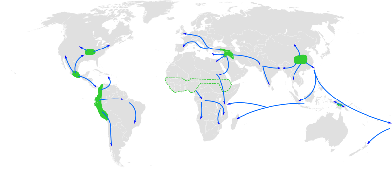
English: Map of the world showing approximate centres of origin of agriculture and its spread in prehistory: eastern USA (4000-3000 BP), Central Mexico (5000-4000 BP), Northern South America (5000-4000 BP), sub-Saharan Africa (5000-4000 BP, exact location unknown), the Fertile Crescent (11000 BP), the Yangtze and Yellow River basins (9000 BP) and the New Guinea Highlands (9000-6000 BP). A proposed centre of origin in Amazonia (Lathrap 1977) is not shown. Adapted from File:BlankMap-World6, compact.svg and Diamond, J. (2003). "Farmers and Their Languages: The First Expansions". Science 300: 597–603. DOI:10.1126/science.1078208. "Fig. 1" |
| Datum | |
| Bron | Eigen werk |
| Auteur | Joe Roe |
Afgeleide werken van dit bestand:
- Centres of origin and spread of agriculture v2.svg
- Ursprungszentren und Verbreitung der Landwirtschaft im Zuge der neolithische Revolution.png
Licentie
Ik, de auteursrechthebbende van dit werk, maak het hierbij onder de volgende licenties beschikbaar:
Dit bestand is gelicenseerd onder de Creative Commons-licentie Naamsvermelding-Gelijk delen 3.0 Unported
- De gebruiker mag:
- Delen – het werk kopiëren, verspreiden en doorgeven
- Remixen – afgeleide werken maken
- Onder de volgende voorwaarden:
- naamsvermelding – U moet op een gepaste manier aan naamsvermelding doen, een link naar de licentie geven, en aangeven of er wijzigingen in het werk zijn aangebracht. U mag dit op elke redelijke manier doen, maar niet zodanig dat de indruk wordt gewekt dat de licentiegever instemt met uw werk of uw gebruik van zijn werk.
- Gelijk delen – Als u het werk heeft geremixt, veranderd, of erop heeft voortgebouwd, moet u het gewijzigde materiaal verspreiden onder dezelfde licentie als het oorspronkelijke werk, of een daarmee compatibele licentie.

|
Toestemming wordt verleend voor het kopiëren, verspreiden en/of wijzigen van dit document onder de voorwaarden van de GNU-licentie voor vrije documentatie, versie 1.2 of enige latere versie als gepubliceerd door de Free Software Foundation; zonder Invariant Sections, zonder Front-Cover Texts, en zonder Back-Cover Texts. Een kopie van de licentie is opgenomen in de sectie GNU-licentie voor vrije documentatie. |
U mag zelf één van de licenties kiezen.
Bestandsgeschiedenis
Klik op een datum/tijd om het bestand te zien zoals het destijds was.
| Datum/tijd | Miniatuur | Afmetingen | Gebruiker | Opmerking | |
|---|---|---|---|---|---|
| huidige versie | 23 mei 2013 14:25 | | 940 × 415 (1,62 MB) | Cmglee | Make arrows blue to distinguish arrows and regions. |
| 29 nov 2010 14:35 |  | 940 × 415 (1,67 MB) | Joey Roe | {{Information |Description={{en|1=Map of the world showing approximate centres of agriculture and its spread in prehistory: eastern USA (4000-3000 BP), Central Mexico (5000-4000 BP), Northern South America (5000-4000 BP), sub-Saharan Africa (5000-4000 BP, |
Bestandsgebruik
Dit bestand wordt op de volgende 4 pagina's gebruikt:
Globaal bestandsgebruik
De volgende andere wiki's gebruiken dit bestand:
- Gebruikt op af.wikipedia.org
- Gebruikt op ar.wikipedia.org
- Gebruikt op ast.wikipedia.org
- Gebruikt op as.wikipedia.org
- Gebruikt op az.wikipedia.org
- Gebruikt op bn.wikipedia.org
- Gebruikt op ca.wikipedia.org
- Gebruikt op de.wikipedia.org
- Gebruikt op en.wikipedia.org
- Gebruikt op en.wikiquote.org
- Gebruikt op es.wikipedia.org
- Gebruikt op es.wikibooks.org
- Gebruikt op eu.wikipedia.org
- Gebruikt op fa.wikipedia.org
- Gebruikt op fi.wikipedia.org
- Gebruikt op fr.wikipedia.org
- Gebruikt op hy.wikipedia.org
Globaal gebruik van dit bestand bekijken.