
Bestand:Helsinki tram map 2020.png

Grootte van deze voorvertoning: 518 × 600 pixels. Andere resoluties: 207 × 240 pixels | 415 × 480 pixels | 664 × 768 pixels | 885 × 1.024 pixels | 1.722 × 1.993 pixels.
Oorspronkelijk bestand (1.722 × 1.993 pixels, bestandsgrootte: 2,92 MB, MIME-type: image/png)
| Dit is een bestand van Wikimedia Commons. Onderstaande beschrijving komt van de beschrijving van het bestand daar. |
Beschrijving
| Beschrijving |
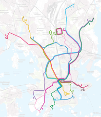
English: Map of the Helsinki tram network as of 14 December 2020.
Suomi: Helsingin raitiotieverkon kartta 14. joulukuuta 2020 lähtien.
Svenska: Kartan över Helsingfors spårvägslinjer från 14 december 2020. |
| Datum | |
| Bron | Own work. Basemap by Maanmittauslaitos (CC BY 4.0). |
| Auteur | Matiasl |
Licentie
Dit bestand is gelicenseerd onder de Creative Commons Naamsvermelding-GelijkDelen 4.0 Internationaal licentie.
- De gebruiker mag:
- Delen – het werk kopiëren, verspreiden en doorgeven
- Remixen – afgeleide werken maken
- Onder de volgende voorwaarden:
- naamsvermelding – U moet op een gepaste manier aan naamsvermelding doen, een link naar de licentie geven, en aangeven of er wijzigingen in het werk zijn aangebracht. U mag dit op elke redelijke manier doen, maar niet zodanig dat de indruk wordt gewekt dat de licentiegever instemt met uw werk of uw gebruik van zijn werk.
- Gelijk delen – Als u het werk heeft geremixt, veranderd, of erop heeft voortgebouwd, moet u het gewijzigde materiaal verspreiden onder dezelfde licentie als het oorspronkelijke werk, of een daarmee compatibele licentie.
Bestandsgeschiedenis
Klik op een datum/tijd om het bestand te zien zoals het destijds was.
| Datum/tijd | Miniatuur | Afmetingen | Gebruiker | Opmerking | |
|---|---|---|---|---|---|
| huidige versie | 4 feb 2022 15:39 | | 1.722 × 1.993 (2,92 MB) | Matiasl | Reverted to version as of 13:37, 4 February 2022 (UTC) |
| 4 feb 2022 15:38 |  | 1.722 × 1.994 (3,23 MB) | Matiasl | Reverted to version as of 17:58, 7 May 2021 (UTC) | |
| 4 feb 2022 15:37 |  | 1.722 × 1.993 (2,92 MB) | Matiasl | October 2021 changes to the network | |
| 7 mei 2021 19:58 |  | 1.722 × 1.994 (3,23 MB) | Matiasl | May 2021 changes to the network | |
| 14 dec 2020 02:16 |  | 1.700 × 1.998 (2,89 MB) | Matiasl | Uploaded a work by Matiasl from Own work. Basemap by Maanmittauslaitos (CC BY 4.0). with UploadWizard |
Bestandsgebruik
Dit bestand wordt op de volgende pagina gebruikt:
Globaal bestandsgebruik
De volgende andere wiki's gebruiken dit bestand:
- Gebruikt op ar.wikipedia.org
- Gebruikt op de.wikipedia.org
- Gebruikt op en.wikivoyage.org
- Gebruikt op fi.wikipedia.org
- Gebruikt op fr.wikipedia.org
- Gebruikt op hu.wikipedia.org
- Gebruikt op pl.wikipedia.org
- Gebruikt op ru.wikipedia.org
- Gebruikt op sv.wikipedia.org
- Gebruikt op uk.wikipedia.org
- Gebruikt op www.wikidata.org