
Bestand:Spain and Portugal.png

Grootte van deze voorvertoning: 800 × 411 pixels. Andere resoluties: 320 × 164 pixels | 640 × 329 pixels | 1.024 × 526 pixels | 1.500 × 771 pixels.
Oorspronkelijk bestand (1.500 × 771 pixels, bestandsgrootte: 92 kB, MIME-type: image/png)
| Dit is een bestand van Wikimedia Commons. Onderstaande beschrijving komt van de beschrijving van het bestand daar. |
Beschrijving

|
Deze kaartafbeelding zou opnieuw moeten worden aangemaakt als een SVG-bestand door vectorafbeeldingen te gebruiken. Dit heeft een aantal voordelen; zie Commons:Media for cleanup voor meer informatie. Als er een SVG-formaat van deze afbeelding bestaat, dan deze graag uploaden. Nadat u dit heeft gedaan, gelieve dit sjabloon te vervangen door het sjabloon {{vector version available|nieuwe bestandsnaam.svg}} op deze afbeeldingspagina.
|
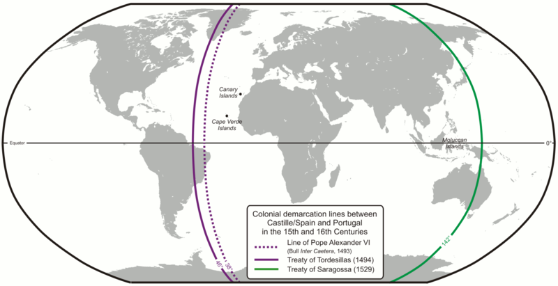
| Beschrijving | Colonial demarcation lines between Castille/Spain and Portugal in the 15th and 16th Centuries. (Treaty of Tordesillas and Treaty of Saragossa) |
| Datum | |
| Bron | Eigen werk |
| Auteur | Lencer |
| Andere versies |
|


|
Deze kaart is gemaakt of verbeterd in de Duitse Kartenwerkstatt (Map Lab). Je kunt ook zelf kaarten ter verbetering voorstellen.
|
Licentie
The map has been created with the Generic Mapping Tools: https://www.generic-mapping-tools.org/ using one or more of these public-domain datasets for the relief:
|

|
Toestemming wordt verleend voor het kopiëren, verspreiden en/of wijzigen van dit document onder de voorwaarden van de GNU-licentie voor vrije documentatie, versie 1.2 of enige latere versie als gepubliceerd door de Free Software Foundation; zonder Invariant Sections, zonder Front-Cover Texts, en zonder Back-Cover Texts. Een kopie van de licentie is opgenomen in de sectie GNU-licentie voor vrije documentatie. |
| Dit bestand is gelicenseerd onder de Creative Commons-licentie Naamsvermelding-Gelijk delen 3.0 Unported | ||
| ||
| Deze licentietag is toegevoegd aan dit bestand in verband met de GFDL licentie-update. |
Bestandsgeschiedenis
Klik op een datum/tijd om het bestand te zien zoals het destijds was.
| Datum/tijd | Miniatuur | Afmetingen | Gebruiker | Opmerking | |
|---|---|---|---|---|---|
| huidige versie | 16 feb 2013 09:52 | | 1.500 × 771 (92 kB) | JohnnyMrNinja | indexed colors and increased compression |
| 7 dec 2007 11:10 |  | 1.500 × 771 (254 kB) | Lencer | {{Convert to SVG|map}} {{Information |Description= Karte der spanischen und portugiesischen Einflussbereiche nach den Verträgen von Tordesillas, Saragossa und [[:de:Vertrag von Alcaçovas|Alca |
Bestandsgebruik
Dit bestand wordt op de volgende 2 pagina's gebruikt:
Globaal bestandsgebruik
De volgende andere wiki's gebruiken dit bestand:
- Gebruikt op ar.wikipedia.org
- Gebruikt op ast.wikipedia.org
- Gebruikt op ca.wikipedia.org
- Gebruikt op cs.wikipedia.org
- Gebruikt op el.wikipedia.org
- Gebruikt op en.wikipedia.org
- 1529
- Treaty of Tordesillas
- Portuguese Empire
- Spanish Empire
- Age of Discovery
- Spanish Canadians
- Slavery in colonial Spanish America
- Portuguese maritime exploration
- Alexandre de Gusmão
- List of territorial claims and designations in Colorado
- Territorial evolution of California
- Treaty of Zaragoza
- User:Mcapdevila/LatMaps
- User:Falcaorib/Spanish and Portuguese Empires
- Gebruikt op en.wikivoyage.org
- Gebruikt op eo.wikipedia.org
- Gebruikt op es.wikipedia.org
- Gebruikt op et.wikipedia.org
- Gebruikt op fa.wikipedia.org
- Gebruikt op fi.wikipedia.org
- Gebruikt op fr.wikipedia.org
- Gebruikt op hy.wikipedia.org
- Gebruikt op id.wikipedia.org
- Gebruikt op it.wikipedia.org
Globaal gebruik van dit bestand bekijken.