
Bestand:Un-guatemala.png
Oorspronkelijk bestand (2.493 × 2.947 pixels, bestandsgrootte: 1,8 MB, MIME-type: image/png)
| Dit is een bestand van Wikimedia Commons. Onderstaande beschrijving komt van de beschrijving van het bestand daar. |
| This image is a map derived from a United Nations map.
Unless stated otherwise, UN maps are to be considered in the public domain. This applies worldwide. UN maps are, in principle, open source material and you can use them in your work or for making your own map. UN requests however that you delete the UN name, logo and reference number upon any modification to the map. Content of your map will be your responsibility. You can state in your publication, if you wish, something like: based on UN map … (map name, map number, revision number and date). See: Geospatial Information Section. And: Geospatial, location data for a better world. |
 |
| Beschrijving |
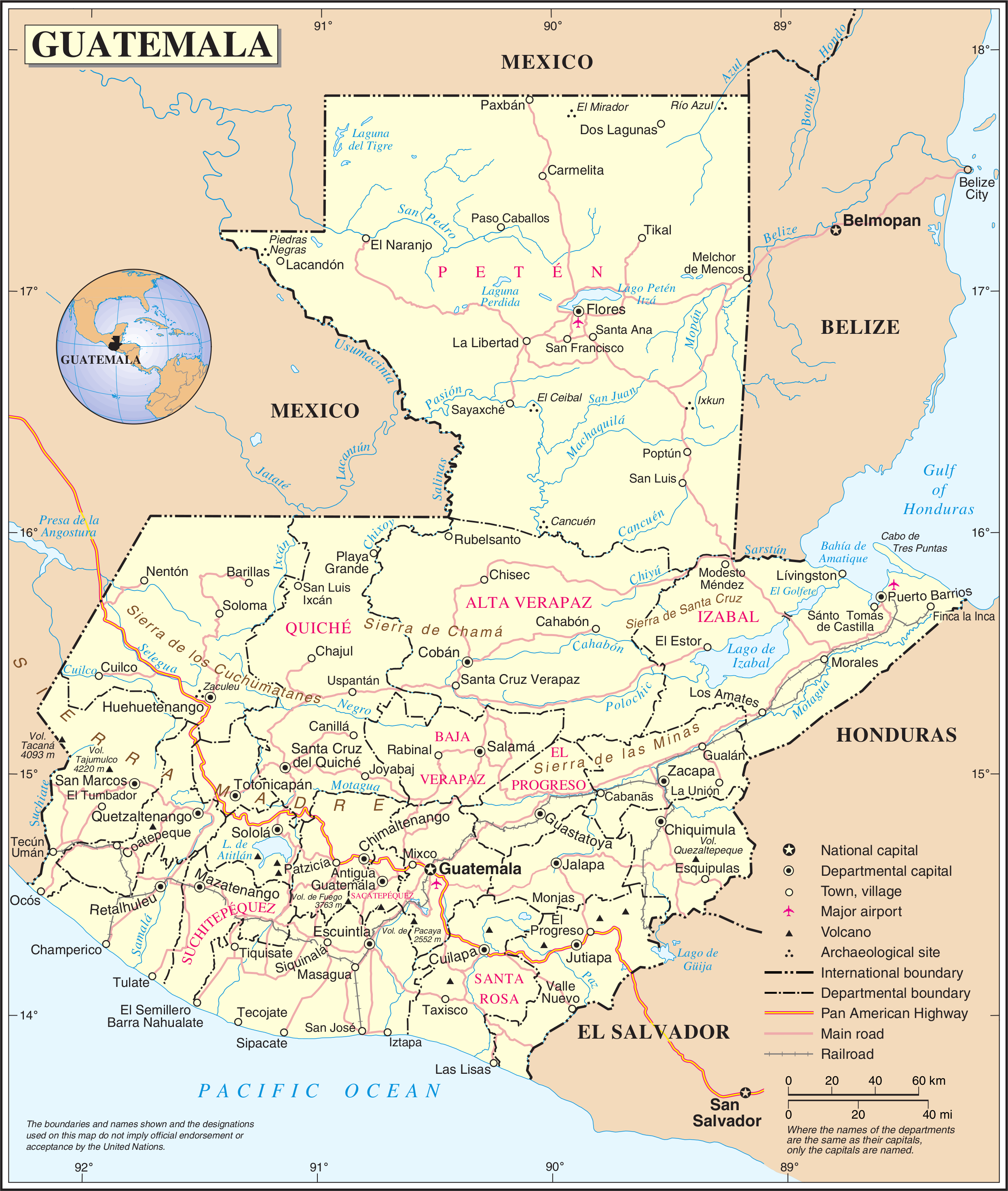
English: Political map of Guatemala generated by the United Nations. |
| Datum | |
| Bron | United Nations Geospatial Information Section |
| Auteur | United Nations Department of Peacekeeping Operations Cartographic Section |
Bestandsgeschiedenis
Klik op een datum/tijd om het bestand te zien zoals het destijds was.
| Datum/tijd | Miniatuur | Afmetingen | Gebruiker | Opmerking | |
|---|---|---|---|---|---|
| huidige versie | 24 okt 2007 03:04 | | 2.493 × 2.947 (1,8 MB) | Jeroen | {{UN map}} Category:Maps of Guatemala |
Bestandsgebruik
Dit bestand wordt op de volgende 3 pagina's gebruikt:
Globaal bestandsgebruik
De volgende andere wiki's gebruiken dit bestand:
- Gebruikt op af.wikipedia.org
- Gebruikt op ar.wikipedia.org
- Gebruikt op be-tarask.wikipedia.org
- Gebruikt op ckb.wikipedia.org
- Gebruikt op el.wikipedia.org
- Gebruikt op en.wikipedia.org
- Geography of Guatemala
- List of places in Guatemala
- Carlos Castillo Armas
- 1954 Guatemalan coup d'état
- Water supply and sanitation in Guatemala
- Outline of Guatemala
- Guatemala
- List of rivers of Guatemala
- Index of Guatemala-related articles
- Water resources management in Guatemala
- United Nations Security Council Resolution 1094
- User:Nlyemica/sandbox
- Gebruikt op es.wikipedia.org
- Gebruikt op fa.wikipedia.org
- Gebruikt op fi.wikipedia.org
- Gebruikt op gom.wikipedia.org
- Gebruikt op id.wikipedia.org
- Gebruikt op kbp.wikipedia.org
- Gebruikt op kn.wikipedia.org
- Gebruikt op lez.wikipedia.org
- Gebruikt op mzn.wikipedia.org
- Gebruikt op pl.wiktionary.org
- Gebruikt op ro.wikipedia.org
- Gebruikt op ru.wikipedia.org
- Gebruikt op sl.wikipedia.org
- Gebruikt op ta.wikipedia.org
- Gebruikt op te.wikipedia.org
- Gebruikt op to.wikipedia.org
- Gebruikt op uk.wikipedia.org
- Gebruikt op uk.wiktionary.org
- Gebruikt op www.wikidata.org
- Gebruikt op zh.wikipedia.org