
Bestand:1860 Pocket Map of Central Park, New York City - Geographicus - CentralPark-olmstead-1860.jpg
Oorspronkelijk bestand (6.000 × 1.317 pixels, bestandsgrootte: 1,94 MB, MIME-type: image/jpeg)
| Dit is een bestand van Wikimedia Commons. Onderstaande beschrijving komt van de beschrijving van het bestand daar. |
| Map of the Central Park Showing the Progress of the Work up to January 1st, 1860. | ||||||
|---|---|---|---|---|---|---|
| Kunstenaar | ||||||
| Titel |
Map of the Central Park Showing the Progress of the Work up to January 1st, 1860. |
|||||
| Beschrijving |
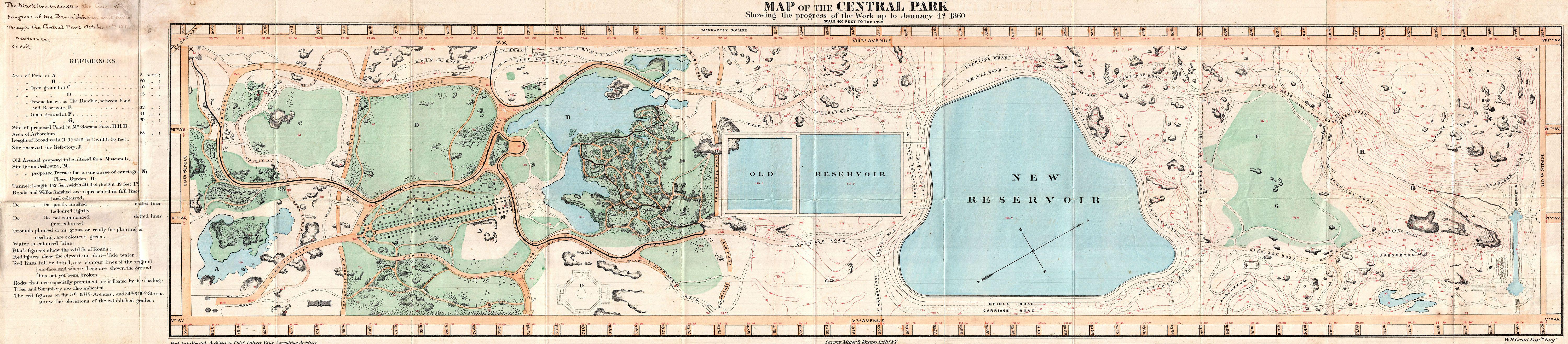
English: A very attractive 1860 pocket map of New York City’s Central Park. This is an extremely rare pocket map variant on the map of Central Park that later appeared in the 1860 Commissioner's Annual Report on the Progress of Central Park . This map is not listed in Haskell and to our knowledge was not issued to the public in pocket format – only in the Commissioner's Annual Report . Most likely it was available only to those city officials actually involved in the planning and construction of Central Park. In this case, said official was the important New York Lawyer A. H. Green. This extraordinary map reveals Central Park as conceived by the Landscape Architects, and indeed “artists”, Vaux and Olmstead. Vaux and Olmstead were awarded the task of designing Central Park in 1853 by the City Common Council. Olmstead’s vision drove the overall design while Vaux concentrated his attentions on bridges, buildings, and other structures within the park. The creation of Central Park, which was to consist of some 800 acres of public forest, pathways, promenades, lakes, bridges, and meadows, was a seminal moment in civic urban design. The park itself was designed as a whole with every tree, pond, and bench meticulously planned. Olmstead wrote: “Every foot of the parks surface, every tree and bush, as well as every arch, roadway, and walk and been placed where it is for a purpose.” Historian Gloria Deak writes, There was a staggering amount of work to be done to transform the area into a blend of pastoral and woodland scenery. This involved the design and construction of roadways, tunnels, bridges, arches, stairways, fountains, benches, lamp posts, gates, fences and innumerable other artifacts. It also involved the supervision of an army of about five thousand laborers…Olmsted, to whom most of the credit goes, insisted on seeing the multidimensional project as a single work of art, which he was mandated to create. For this purpose, he ventured to assume to himself the title of ‘artist.’ Today, because of Vaux and Olmstead’s efforts, New York Yorkers, ourselves included, have the privilege of enjoying what is, perhaps, the finest example of a planned urban public recreation area in the world. This map also features a manuscript annotation showing the progress of Baron Renfrew through Central Park on October 12, 1860. Baron Renfrew is one of the titles associated with the Prince of Wales and was commonly used when the Price wanted to make an “unofficial” trip – as with his 1860 visit to New York. In this case, Baron Renfew is Prince Albert Edward who was 19 at the time. The Prince Albert Edward acceded in 1901 as Edward VII. Though most maps are without substantial provenance, this map is known to have been originally owned by the prominent 19th century New Yorker Andrew Haswell Green (1820 - November 13, 1903). A. H. Green was a New York lawyer, city planner, civic leader and agitator for reform. Called by some historians a hundred years later the 19th century Robert Moses, he held several offices and played important roles in many New York projects, including the development of Riverside Drive, Morningside Park, Fort Washington Park, and Central Park. His last great project was the consolidation of the Imperial City or “City of Greater New York” from the earlier cities of New York, Brooklyn and Long Island City, and still largely rural parts of Westchester, Richmond and Queens Counties. In 1903 Green was murdered in a case of mistaken identity. He is buried in Worcester. In 1905 his family estate in Worchester was turned into a public park. Green's personal effects and other belongings were stored for over 100 years until recently being rediscovered and offed for sale. |
|||||
| Datum | 1860 (dated) | |||||
| Afmetingen | hoogte: 8,7 in (22,2 cm); breedte: 39 in (99 cm) | |||||
| Inventarisnummer |
Geographicus link: CentralPark-olmstead-1860 |
|||||
| Bron/fotograaf |
|
|||||
| Toestemming (Hergebruik van dit bestand) |
|
|||||
Bestandsgeschiedenis
Klik op een datum/tijd om het bestand te zien zoals het destijds was.
| Datum/tijd | Miniatuur | Afmetingen | Gebruiker | Opmerking | |
|---|---|---|---|---|---|
| huidige versie | 25 mrt 2011 03:13 | 6.000 × 1.317 (1,94 MB) | BotMultichillT | {{subst:User:Multichill/Geographicus |link=http://www.geographicus.com/P/AntiqueMap/CentralPark-olmstead-1860 |product_name=1860 Pocket Map of Central Park, New York City |map_title=Map of the Central Park Showing the Progress of the Work up to January 1s |
Bestandsgebruik
Dit bestand wordt op de volgende 2 pagina's gebruikt: