
Bestand:2006 North Korean nuclear test.svg

Afmetingen van deze voorvertoning van het type PNG van dit SVG-bestand: 473 × 408 pixels Andere resoluties: 278 × 240 pixels | 557 × 480 pixels | 890 × 768 pixels | 1.187 × 1.024 pixels | 2.374 × 2.048 pixels.
Oorspronkelijk bestand (SVG-bestand, nominaal 473 × 408 pixels, bestandsgrootte: 71 kB)
| Dit is een bestand van Wikimedia Commons. Onderstaande beschrijving komt van de beschrijving van het bestand daar. |
Beschrijving
| Beschrijving |
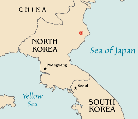
Map of the North Korean nuclear test of October 9, 2006. The red marker indicates the estimated location of the test (41.311°N, 129.114°E). Based off of maps from the CIA World Factbook. |
| Datum | 10 oktober 2006 (originele uploaddatum) |
| Bron | Geen machineleesbare bron opgegeven. Eigen werk aangenomen (gebaseerd op auteursrechtclaims). |
| Auteur | Geen machineleesbare auteur aanwezig. Op basis van auteursrechtclaims wordt auteur Mobius aangenomen. |
| Andere versies |
|


Licentie
| Ik, de auteursrechthebbende van dit werk, geef dit werk vrij in het publieke domein. Dit is wereldwijd van toepassing. In sommige landen is dit wettelijk niet mogelijk; in die gevallen geldt: Ik sta iedereen toe dit werk voor eender welk doel te gebruiken, zonder enige voorwaarden, tenzij zulke voorwaarden door de wet worden voorgeschreven. |
Bestandsgeschiedenis
Klik op een datum/tijd om het bestand te zien zoals het destijds was.
| Datum/tijd | Miniatuur | Afmetingen | Gebruiker | Opmerking | |
|---|---|---|---|---|---|
| huidige versie | 10 okt 2006 22:48 | | 473 × 408 (71 kB) | Mobius | + Crop area, proper license |
| 10 okt 2006 22:43 |  | 981 × 801 (71 kB) | Mobius | Map of the North Korean nuclear test of October 9, 2006. The red marker indicates the estimated location of the test (41.311°N, 129.114°E). Based off of maps from the CIA World Factbook. |
Bestandsgebruik
Dit bestand wordt op de volgende 2 pagina's gebruikt:
Globaal bestandsgebruik
De volgende andere wiki's gebruiken dit bestand:
- Gebruikt op ca.wikipedia.org
- Gebruikt op en.wikipedia.org
- Gebruikt op ia.wikipedia.org
- Gebruikt op ko.wikipedia.org
- Gebruikt op no.wikipedia.org
- Gebruikt op pl.wikinews.org
- Gebruikt op ta.wikinews.org
- Gebruikt op www.wikidata.org