
Bestand:Achaemenid Empire at its greatest extent according to Oxford Atlas of World History 2002.jpg

Grootte van deze voorvertoning: 800 × 600 pixels. Andere resoluties: 320 × 240 pixels | 640 × 480 pixels | 1.024 × 768 pixels | 1.280 × 960 pixels | 2.560 × 1.920 pixels | 3.000 × 2.250 pixels.
Oorspronkelijk bestand (3.000 × 2.250 pixels, bestandsgrootte: 1,71 MB, MIME-type: image/jpeg)
| Dit is een bestand van Wikimedia Commons. Onderstaande beschrijving komt van de beschrijving van het bestand daar. |


Beschrijving
| Beschrijving |
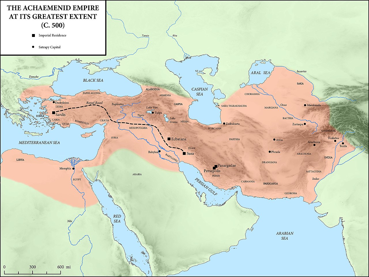
English: Achaemenid Empire at its greatest extent according to Oxford Atlas of World History 2002. Sources:
|
| Datum | |
| Bron |
Dit bestand is afgeleid van: The Achaemenid Empire at its Greatest Extent.jpg |
| Auteur |
Original creator: Mossmaps |
Licentie
Dit bestand is gelicenseerd onder de Creative Commons Naamsvermelding-GelijkDelen 4.0 Internationaal licentie.
- De gebruiker mag:
- Delen – het werk kopiëren, verspreiden en doorgeven
- Remixen – afgeleide werken maken
- Onder de volgende voorwaarden:
- naamsvermelding – U moet op een gepaste manier aan naamsvermelding doen, een link naar de licentie geven, en aangeven of er wijzigingen in het werk zijn aangebracht. U mag dit op elke redelijke manier doen, maar niet zodanig dat de indruk wordt gewekt dat de licentiegever instemt met uw werk of uw gebruik van zijn werk.
- Gelijk delen – Als u het werk heeft geremixt, veranderd, of erop heeft voortgebouwd, moet u het gewijzigde materiaal verspreiden onder dezelfde licentie als het oorspronkelijke werk, of een daarmee compatibele licentie.
Bestandsgeschiedenis
Klik op een datum/tijd om het bestand te zien zoals het destijds was.
| Datum/tijd | Miniatuur | Afmetingen | Gebruiker | Opmerking | |
|---|---|---|---|---|---|
| huidige versie | 12 aug 2022 17:06 | | 3.000 × 2.250 (1,71 MB) | Claude Zygiel | Coastlines of the 5th cen. BC: see please the discussion file. This is not an ancient map. |
| 20 okt 2018 17:15 |  | 3.000 × 2.250 (2,62 MB) | पाटलिपुत्र | User created page with UploadWizard |
Bestandsgebruik
Dit bestand wordt op de volgende pagina gebruikt:
Globaal bestandsgebruik
De volgende andere wiki's gebruiken dit bestand:
- Gebruikt op ar.wikipedia.org
- Gebruikt op bg.wikipedia.org
- Gebruikt op bn.wikipedia.org
- Gebruikt op ceb.wikipedia.org
- Gebruikt op cs.wikipedia.org
- Gebruikt op de.wikipedia.org
- Gebruikt op en.wikipedia.org
- History of Afghanistan
- History of Asia
- Ancient history
- History of Iran
- Royal Road
- Cursus publicus
- Portal:Iran
- Historic roads and trails
- Comana Pontica
- Achaemenid coinage
- Portal:Asia
- Maka (satrapy)
- Return to Zion
- Portal:Afghanistan
- Yehud Medinata
- Angarum
- Achaemenid Empire
- Classical Anatolia
- DNa inscription
- Apadana hoard
- User talk:LouisAragon/Archive 4
- User:Falcaorib
- User:Northamerica1000/Portals of the world
- User:Lodzdeena/Əfqanıstan tarixi
- Gebruikt op es.wikipedia.org
- Gebruikt op eu.wikipedia.org
- Gebruikt op fa.wikipedia.org
- Gebruikt op fr.wikipedia.org
- Gebruikt op gl.wikipedia.org
- Gebruikt op hy.wikipedia.org
- Gebruikt op ka.wikipedia.org
- Gebruikt op lfn.wikipedia.org
Globaal gebruik van dit bestand bekijken.