
Bestand:AgrihanNASA.jpg

Grootte van deze voorvertoning: 800 × 535 pixels. Andere resoluties: 320 × 214 pixels | 640 × 428 pixels | 1.000 × 669 pixels.
Oorspronkelijk bestand (1.000 × 669 pixels, bestandsgrootte: 144 kB, MIME-type: image/jpeg)
| Dit is een bestand van Wikimedia Commons. Onderstaande beschrijving komt van de beschrijving van het bestand daar. |
Beschrijving
| Beschrijving |
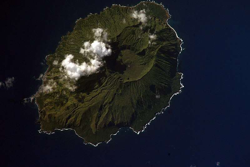
English: NASA Space Shuttle image of Agrihan island in the Northern Mariana Islands.
|
||||||||||||||||||||||||||||||||||||||||||||||||||
| Locatie | Northern Mariana Islands | ||||||||||||||||||||||||||||||||||||||||||||||||||
| Datum | |||||||||||||||||||||||||||||||||||||||||||||||||||
| Bron |
|
||||||||||||||||||||||||||||||||||||||||||||||||||
| Auteur | NASA | ||||||||||||||||||||||||||||||||||||||||||||||||||
| Objectlocatie | | Deze en andere afbeeldingen in: OpenStreetMap |
|---|
Deze afbeelding of video is gecatalogiseerd door een van de centrums van de Verenigde Staten National Aeronautics and Space Administration (NASA)onder Foto ID: ISS006-E-42419.Deze banner zegt niets over de auteursrechten die van toepassing zijn. Een normale auteursrechten-tag is nodig. Zie Commons:Licensing voor meer informatie. Andere talen:
|
Licentie
This file is in the public domain in the United States because it was created by the Image Science & Analysis Laboratory, of the NASA Johnson Space Center. NASA copyright policy states that "NASA material is not protected by copyright unless noted". (NASA media use guidelines or Conditions of Use of Astronaut Photographs).
Photo source: ISS006-E-42419.
|
Bestandsgeschiedenis
Klik op een datum/tijd om het bestand te zien zoals het destijds was.
| Datum/tijd | Miniatuur | Afmetingen | Gebruiker | Opmerking | |
|---|---|---|---|---|---|
| huidige versie | 22 apr 2007 06:54 | | 1.000 × 669 (144 kB) | Seattle Skier | == Summary == {{Information |Description= NASA Space Shuttle image of Agrihan island in the Northern Mariana Islands. |Source= http://www.oceandots.com/pacific/mariana/agrihan.htm |Date= 01 April 2003 |Location = [[Northern Mariana Islands |
Bestandsgebruik
Dit bestand wordt op de volgende pagina gebruikt:
Globaal bestandsgebruik
De volgende andere wiki's gebruiken dit bestand:
- Gebruikt op arz.wikipedia.org
- Gebruikt op ast.wikipedia.org
- Gebruikt op ceb.wikipedia.org
- Gebruikt op de.wikipedia.org
- Gebruikt op en.wikipedia.org
- Gebruikt op en.wiktionary.org
- Gebruikt op eo.wikipedia.org
- Gebruikt op es.wikipedia.org
- Gebruikt op et.wikipedia.org
- Gebruikt op fa.wikipedia.org
- Gebruikt op fi.wikipedia.org
- Gebruikt op fr.wikipedia.org
- Gebruikt op fr.wikiquote.org
- Gebruikt op gcr.wikipedia.org
- Gebruikt op gl.wikipedia.org
- Gebruikt op it.wikipedia.org
- Gebruikt op ja.wikipedia.org
- Gebruikt op ka.wikipedia.org
- Gebruikt op ko.wikipedia.org
- Gebruikt op lld.wikipedia.org
- Gebruikt op ms.wikipedia.org
- Gebruikt op mzn.wikipedia.org
- Gebruikt op pl.wikipedia.org
- Gebruikt op pt.wiktionary.org
- Gebruikt op ru.wikipedia.org
- Gebruikt op ru.wiktionary.org
- Gebruikt op sk.wikipedia.org
- Gebruikt op sv.wikipedia.org
- Gebruikt op ur.wikipedia.org
- Gebruikt op vi.wikipedia.org
- Gebruikt op www.wikidata.org
- Gebruikt op zh.wikipedia.org