
Bestand:Alexander Mackenzie map.jpg
Grootte van deze voorvertoning: 773 × 600 pixels. Andere resoluties: 310 × 240 pixels | 619 × 480 pixels | 990 × 768 pixels | 1.280 × 993 pixels | 2.560 × 1.986 pixels | 5.879 × 4.560 pixels.
Oorspronkelijk bestand (5.879 × 4.560 pixels, bestandsgrootte: 9,24 MB, MIME-type: image/jpeg)
| Dit is een bestand van Wikimedia Commons. Onderstaande beschrijving komt van de beschrijving van het bestand daar. |
Beschrijving
| Beschrijving |
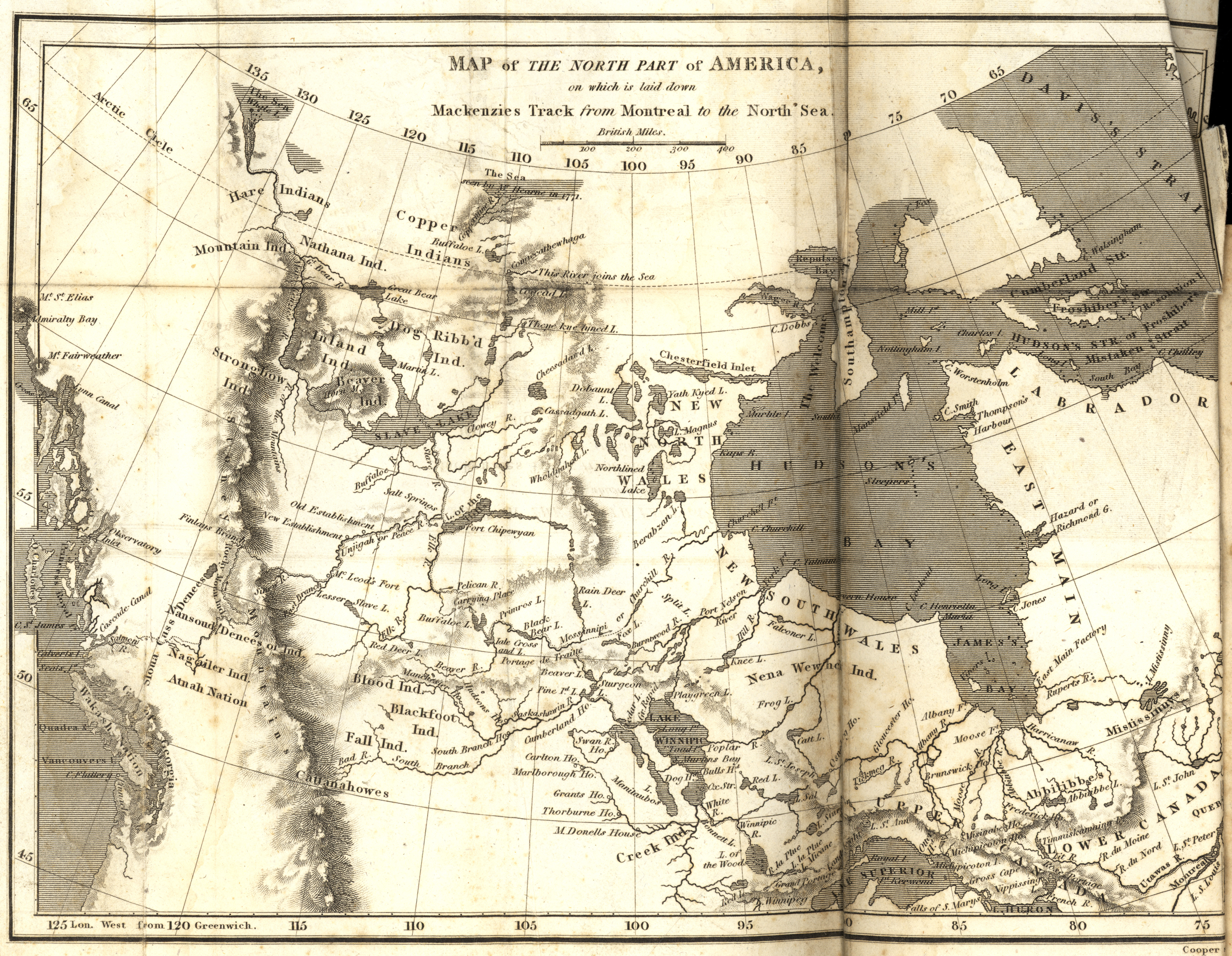
Mackenzie, Alexander. Map of the North Part of America on which is laid down Mackenzies Track (dotted line) from Montreal to the North Sea [map] Scale not given. In: A Collection of Voyages and Travels, from the Discovery of America to the Commencement of the Nineteenth Century (Volume 24). London: 1809. Image Courtesy of University of Manitoba Archives & Special Collections |
| Datum | |
| Bron | Map of the North Part of America on which is laid down Mackenzies Track from Montreal to the North Sea (1809) |
| Auteur | Manitoba Historical Maps |
Licentie
Dit bestand is gelicenseerd onder de Creative Commons-licentie Naamsvermelding 2.0 Unported
- De gebruiker mag:
- Delen – het werk kopiëren, verspreiden en doorgeven
- Remixen – afgeleide werken maken
- Onder de volgende voorwaarden:
- naamsvermelding – U moet op een gepaste manier aan naamsvermelding doen, een link naar de licentie geven, en aangeven of er wijzigingen in het werk zijn aangebracht. U mag dit op elke redelijke manier doen, maar niet zodanig dat de indruk wordt gewekt dat de licentiegever instemt met uw werk of uw gebruik van zijn werk.
| Deze afbeelding, die oorspronkelijk op Flickr geplaatst is, is gecontroleerd op September 14, 2010 door de moderator of vertrouwde gebruiker File Upload Bot (Magnus Manske), die bevestigt dat het destijds beschikbaar was op Flickr onder de genoemde licentie. |
Bestandsgeschiedenis
Klik op een datum/tijd om het bestand te zien zoals het destijds was.
| Datum/tijd | Miniatuur | Afmetingen | Gebruiker | Opmerking | |
|---|---|---|---|---|---|
| huidige versie | 14 sep 2010 08:19 | | 5.879 × 4.560 (9,24 MB) | File Upload Bot (Magnus Manske) | {{Information |Description=Mackenzie, Alexander. Map of the North Part of America on which is laid down Mackenzies Track from Montreal to the North Sea [map] Scale not given. In: A Collection of Voyages and Travels, from the Discovery of America to the Co |
Bestandsgebruik
Dit bestand wordt op de volgende pagina gebruikt:
Globaal bestandsgebruik
De volgende andere wiki's gebruiken dit bestand:
- Gebruikt op en.wikipedia.org
- Gebruikt op es.wikipedia.org
- Gebruikt op fr.wikipedia.org